
Loch Heron


Crannog(S) (Period Unassigned)
Site Name Loch Heron
Classification Crannog(S) (Period Unassigned)
Canmore ID 62396
Site Number NX26SE 2
NGR NX 2717 6482
NGR Description NX 2717 6482 and NX 2718 6473
Datum OSGB36 - NGR
Permalink http://canmore.org.uk/site/62396


- Council Dumfries And Galloway
- Parish Kirkcowan
- Former Region Dumfries And Galloway
- Former District Wigtown
- Former County Wigtownshire
NX26SE 2 2717 6482 and 2718 6473
(NX 2718 6473) Lake Dwelling (NR) (Site of)
OS 6" map (1957)
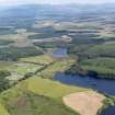
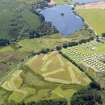
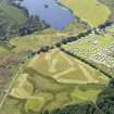
There are two islands in Loch Heron. One (at NX 2717 6482) is overgrown with trees and bushes and the other was, when visited, submerged, and only discernible from the reeds above the surface. A hole was sunk in the former some years ago and its artificial character established. The latter is also said to be a crannog, but its condition makes examination impracticable. M'Kerlie, however, states that both islands were recently found to be crannogs, with "the usual remains, such as ashes, and fragments of bones, etc, found; the transverse oak beams were traced, with piles of hazel and birch."
G Wilson 1873; P H M'Kerlie 1877; RCAHMS 1912, visited 1911.
The northernmost of these two crannogs is still visible from the shore as an island 28.0m N-S by 20.0m transversely. The other crannog is only discernible by a patch of reeds.
Crannog surveyed at 1:10 000.
Visited by OS (BS) 1 July 1976
NX 2717 6482 Loch Heron, crannogs I and II (NX26SE 2). A contour survey was carried out of both crannogs in Loch Heron. Loch Heron I is the island visible in the centre of the loch and consists of large sub-angular to rounded boulders, averaging c 0.5m in diameter, and is covered in a thick layer of lacustrine organic silts. The mound is relatively large, measuring 51m NW-SE by 26m. The height from base to top is 2.2m.
Visibility in Loch Heron is poor, at less than 0.5m, but diving inspection confirmed that the island is constructed using massive timbers, both piles and horizontals. The species of these structural timbers could not be determined since they were for the most part detected by feeling beneath the silt, and visibility was quickly reduced to zero by this action. In several places, however, timbers in excess of 40cm in diameter were noted, protruding from the basal levels of the mound. The poor visibility made this difficult to determine, but it seems probable that Loch Heron I utilises a naturally raised spar of loch bed. This raised area appears to curve from NW to SE, and Loch Heron II is located at the SE end of this spar. The loch bed between the two sites is raised, and occasional stones and boulders were noted between the two sites, but no evidence of a stone or timber causeway was detected.
Loch Heron II lies 48m to the SE of crannog I, also lying along the axis of the raised loch bed spar. It is totally submerged, though a fallen tree which has washed onto the surface of the site marks its position above the water. The mound consists of stones of average diameter c 30cm, with many timbers protruding from the sides and top of the site. Several of these timbers were soft and rotten, probably indicative of the periodic exposure of the site above water. Again, the site was covered by thick silts, and inspection below the water level was difficult. This site is also reasonably large, at 44m NW-SE by 26m. The mound is less pronounced and has shallower sides than crannog I, however, and measures 1.5m from base to top.
A sample of a vertical pile from each site was taken for radiocarbon dating.
Sponsors: Dumfriesshire & Galloway Natural History and Antiquarian Society, University of Nottingham.
M G Cavers 2004
A third season of fieldwork and survey (see DES 2003, 42-3) on selected crannog sites in Dumfries and Galloway was carried out in July 2004 as part of the Scottish Wetland Archaeology Programme (SWAP). This comprised the underwater examination of six crannog sites selected for monitoring, the installation and surveying of monitoring probes at those sites, and the sampling of timbers from Loch Heron for radiocarbon dating.
NX 1206 6047 Cults Loch (Inch parish), NX16SW 14.
NX 2717 6482 Loch Heron (Kirkcowan parish), NX26SE 2.
NX 9028 6898 Loch Arthur (New Abbey parish), NX96NW 1.
NX 2047 5631 Whitefield Loch (Old Luce parish), NX25NW 7.
NX 2595 5915 Barhapple Loch (Old Luce parish), NX25NE 2.
NX 2047 5631 Barlockhart (Old Luce parish), NX25NW 7.
NX 8388 7188 Milton Loch (Urr parish), NX87SW 4.
Sponsors: HS, Scottish Trust for Archaeological Research, University of Nottingham, AOC Archaeology Group, Underwater Archaeology Research Centre.
J Henderson and M G Cavers 2004.
Field Visit (1 July 1976)
The northernmost of these two crannogs is still visible from the shore as an island 28.0m N-S by 20.0m transversely. The other crannog is only discernible by a patch of reeds.
Crannog surveyed at 1:10 000.
Visited by OS (BS) 1 July 1976
Diver Inspection (July 2004 - July 2004)
A third season of fieldwork and survey (see DES 2003, 42-3) on selected crannog sites in Dumfries and Galloway was carried out in July 2004 as part of the Scottish Wetland Archaeology Programme (SWAP). This comprised the underwater examination of six crannog sites selected for monitoring, the installation and surveying of monitoring probes at those sites, and the sampling of timbers from Loch Heron for radiocarbon dating.
NX 1206 6047 Cults Loch (Inch parish), NX16SW 14.
NX 2717 6482 Loch Heron (Kirkcowan parish), NX26SE 2.
NX 9028 6898 Loch Arthur (New Abbey parish), NX96NW 1.
NX 2047 5631 Whitefield Loch (Old Luce parish), NX25NW 7.
NX 2595 5915 Barhapple Loch (Old Luce parish), NX25NE 2.
NX 2047 5631 Barlockhart (Old Luce parish), NX25NW 7.
NX 8388 7188 Milton Loch (Urr parish), NX87SW 4.
Sponsors: HS, Scottish Trust for Archaeological Research, University of Nottingham, AOC Archaeology Group, Underwater Archaeology Research Centre.
J Henderson and M G Cavers 2004.
Contour Survey (2004)
NX 2717 6482 Loch Heron, crannogs I and II (NX26SE 2). A contour survey was carried out of both crannogs in Loch Heron. Loch Heron I is the island visible in the centre of the loch and consists of large sub-angular to rounded boulders, averaging c 0.5m in diameter, and is covered in a thick layer of lacustrine organic silts. The mound is relatively large, measuring 51m NW-SE by 26m. The height from base to top is 2.2m.
Visibility in Loch Heron is poor, at less than 0.5m, but diving inspection confirmed that the island is constructed using massive timbers, both piles and horizontals. The species of these structural timbers could not be determined since they were for the most part detected by feeling beneath the silt, and visibility was quickly reduced to zero by this action. In several places, however, timbers in excess of 40cm in diameter were noted, protruding from the basal levels of the mound. The poor visibility made this difficult to determine, but it seems probable that Loch Heron I utilises a naturally raised spar of loch bed. This raised area appears to curve from NW to SE, and Loch Heron II is located at the SE end of this spar. The loch bed between the two sites is raised, and occasional stones and boulders were noted between the two sites, but no evidence of a stone or timber causeway was detected.
Loch Heron II lies 48m to the SE of crannog I, also lying along the axis of the raised loch bed spar. It is totally submerged, though a fallen tree which has washed onto the surface of the site marks its position above the water. The mound consists of stones of average diameter c 30cm, with many timbers protruding from the sides and top of the site. Several of these timbers were soft and rotten, probably indicative of the periodic exposure of the site above water. Again, the site was covered by thick silts, and inspection below the water level was difficult. This site is also reasonably large, at 44m NW-SE by 26m. The mound is less pronounced and has shallower sides than crannog I, however, and measures 1.5m from base to top.
A sample of a vertical pile from each site was taken for radiocarbon dating.
Sponsors: Dumfriesshire & Galloway Natural History and Antiquarian Society, University of Nottingham.
M G Cavers 2004

