
Hutton, Union Bridge


Suspension Bridge (19th Century)
Site Name Hutton, Union Bridge
Classification Suspension Bridge (19th Century)
Alternative Name(s) River Tweed; Union Chain Bridge; Hutton Bridge; Union Suspension Bridge; Paxton
Canmore ID 60103
Site Number NT95SW 2
NGR NT 93391 51025
Datum OSGB36 - NGR
Permalink http://canmore.org.uk/site/60103


- Council Scottish Borders, The
- Parish Hutton (Berwickshire)
- Former Region Borders
- Former District Berwickshire
- Former County Berwickshire
NT95SW 2 93391 51025
Union Bridge [NAT]
OS 1:10,000 map, 1978.
NMRC (England) site no. NT95SW 27.
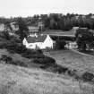
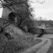
For associated Tweed Cottage (tollhouse, adjacent to W), see NT95SW 28.
Not to be confused with Foulden, Hutton Bridge (over the Whiteadder Water, at NT 92117 54585), for which see NT95SW 60.
The Object Name Book of the Ordnance Survey describes the bridge as'This bridge is distant about two miles and a half from Hutton and is about 6 miles up the Tweed from Berwick. It is an Iron Suspension bridge built or erected in 1820 by Captain Samuel Brown of the Royal Navy.
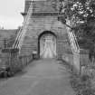
The structure is an admirable specimen of this kind of bridge and completely answers the purpose for which it was intended. It is made of malleable I ron. Its length is 361 feet and its weight 100 tons. A very substantial and elegantarch of Freestone masonry stands on the Scots side - throught which carriages enter upon the platform of the bridge which is made of wood plated of Iron- and is connected with the principal Chains by upright Iron rods. It is to be regretted that the nature of the ground on the English side did not admit of a similar arch being there erected, which would have communicated to the whole structure greater symmetry ...(?).
The whole expense was from £7,000 to £8,000.
Name Book 1861.
NMRS REFERENCE
Architect: Capt Sir Samuel Brown - 1820
Inventory to Duns Castle Drawings - typescript.
Grooms Gazetteer.
(Undated) information in NMRS.
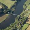
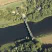
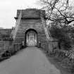
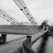
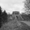
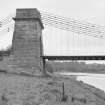
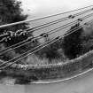
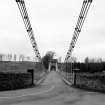
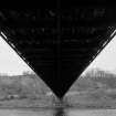
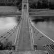
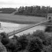
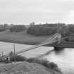
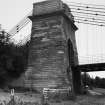
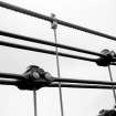
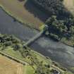
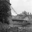
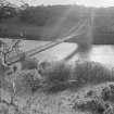
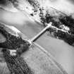
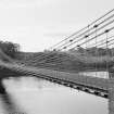
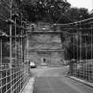
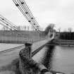
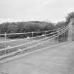
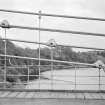
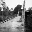
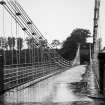
(Location cited as NT 934 511). Union Suspension Bridge, built 1820 (by engineer Captain S Brown) and strengthened 1902-3 (by engineer J A Bean). The first large suspension bridge in Britain. There are three sets of iron link chains on each side, each consisting of pairs of links, with iron-rod suspenders to a light wood-truss deck. The pylons are monumental in design, of dressed stone. Unusually, the pylon on the S side is set back from the end of the truss, into a hillside. The 1902-3 strengthening consisted of adding a wire-rope cable on each side, with wire-rope suspenders to steel reinforcement at the sides of the original dec. There is a light wrought-iron railing of attractive design.
J R Hume 1976.
(Suspension bridge of Samuel Brown chain type: location cited as NT 934 511). Built 1820 by Captain Samuel Brown, engineer, and strengthened in 1902-3 by J A Bean, engineer. Massive masonry pylons, three pairs of iron link chains on each side, iron rod suspenders to wooden deck. The 1902-3 strengthening consisted of adding a single wire-rope cable on each side, with wire-rope suspenders to steel reinforcement at the sides of the wooden deck. The iron railings are unusual and the span of the chains is 437 ft (133m).
J R Hume 1977.
Horncliffe was formerlky a low ford (attracting much traffic) at the furthermost point of the tidal Tweed. Hence the Union Suspension Bridge, built 1819-20 by Captain Sir Samuel Brown, RN, with advice on tower and abutment design from john Rennie. Timber roadway suspended from pairs of wrought-iron chains with elongated bars connected by wrought iron.
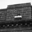
Brown invented the bar link, used here for the first time, constructing the longest suspension bridge of its day. The technological jump was palpable - providing a structure at a quarter of the anticipated cost of a masonry equivalent. Europe's first and oldest surviving suspension bridge carrying road traffic. Look for the iron inscriptions with their intertwined thistles and roses.
C A Strang 1994.
Descheduled.
Information from Historic Scotland, Certificate of Exclusion from Schedule dated 20 December 1999.
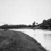
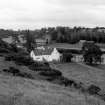
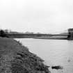
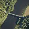
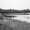
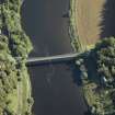
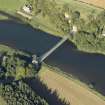
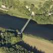
This bridge carries an unclassified public road across the River Tweed, which here forms the Anglo-Scottish border, between the parishes of Hutton (Berwickshire, to the W) and Horncliffe (Northumberland, to the E).
The location assigned to this record defines the centre of the span. The available map evidence suggests that it extends from NT c. 93334 51000 to NT c. 93458 51043.
Information from RCAHMS (RJCM), 1 February 2006.
Union Bridge [NAT]
OS (GIS) MasterMap, April 2010.
Construction (1819 - 1820)
Modification (1903)
Bridge strengthened by addition of chains which will come into play to support the deck if the original chain fails.
Photographic Survey (October 1961)
Photographic survey of Union Bridge, Hutton, Berwickshire, by the Scottish National Buildings Record in October 1961.
Publication Account (1985)
From c 1810 iron came to be used for bridge-building in Scotland, alongside stone: first of all cast-iron, later steel girders. Iron was also used to manufacture suspension cables or chains; at Hutton the chain links were forged from iron bars, though from mid-century iron plate was used.
The Union Chain Bridge was built in 1820 by Royal Navy Captain Samuel Brown, the first large suspension bridge in Britain and predating the Menai
Suspension Bridge in North Wales. It is the largest of three similar bridges in the Borders - the others are at Kalemouth, 1820-30 (NT 708274) and the footbridge at Melrose, 1826 (NT 545346). Strong iron rods connect the 3 sets of iron link chains each side to a light wooden deck, and the chains rise up either end to impressive pylons of well-dressed stone. When the
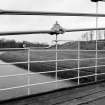
bridge was strengthened in 1902-3, a wire-rope cable and wire-rope suspender linked to steel reinforcements were added each side of the decksome 112 m long, 5.5 m wide and 8.2 m above the river. The carriageway is flanked by attractive wroughtiron railings.
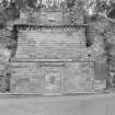
Before the 4-span Ladykirk-Norham bridge was built in 1885-87, the Union Bridge was the only crossing of the Tweed between Berwick-upon-Tweed and Coldstream, other than by ferry or ford. There are former toll-houses, single-storeyed, on the Scottish side of both bridges.
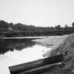
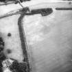
Just north of the bridge, on the Scottish bank (NT 933510), lies a typical Tweed salmon fishery. Dating from the early 19th century, it consists of wooden netdrying supports, a single-storey hut with extensions for stowing gear and a stone-built, vaulted ice-house.
Information from 'Exploring Scotland's Heritage, Lothian and Borders' (1985).
Project (2007)
This project was undertaken to input site information listed in 'Civil engineering heritage: Scotland - Lowlands and Borders' by R Paxton and J Shipway, 2007.
Publication Account (2007)
Union Bridge, near Paxton: Although projected after Telford’s Menai Bridge, which was on a much larger scale, Union Bridge erected over the Tweed four miles west of Berwick in 1819–20 by Capt. Samuel Brown RN was completed first. It has an 18 ft wide deck and for five years was the largest wrought-iron span suspension bridge in the world carrying vehicular traffic, which it still does. It is believed to be the oldest suspension bridge still carrying vehicles and is now subject to a two ton weight limit. The bridge was a triumph of the newly-emerging technology made practicable by Cort’s improvements in ironmanufacture. Brown used his patent wrought-iron chains to achieve a clear span of 361 ft (437 ft between supports), a span several times greater than was practicable by means of a stone arch. The main ironwork consists of individual chains formed of 15 ft 2 in. diameter eye-bar links in three pairs, one above the other, at each side of the deck, with a dip of about 26 ft. The bridge has a supporting tower only on the north bank, being anchored into the rock face at its south end.
Brown’s expertise was in chain manufacture rather than bridge design and his original proposals for the 60 ft tall tower and abutments were considerably improved on the advice of John Rennie. Nevertheless, this application of his eye-bar chains, and its development by Telford at Menai Bridge, undoubtedly exercised an important influence in suspension bridge practice. The bridge was erected in the remarkably short time of 12 months and cost approximately £7700 which was compared at the time with the sum of at least £20 000 for a multi-span masonry arch bridge. Knowledge of Brown’s achievement and of other innovative Scottish wrought-iron suspension bridges was widely spread by Robert Stevenson in his authoritative Edinburgh Philosophical Journal article in 1821, notable for its early description of deck undulation. By 1824 translations of Stevenson’s article had appeared in German, French and Polish publications.
In 1903 the bridge was strengthened by the addition above the chains at each side of a single steel cable and
hangers which will only come into play and support the deck if an original chain fails. In 1974 the bridge was reconditioned including the replacement, in spheroidal graphite iron, of defective short interconnecting links between the original main eye-bars which were retained in service. An original worn link has been preserved in the ICE Museum at Heriot-Watt University, Edinburgh. Shirley-Smith states in his book that the bridgewas blown
down six months after its erection but this is untrue and he may have been confusing it with the fate of the first
Dryburgh suspension bridge. Although not as influential as Menai Bridge, Union Bridge nevertheless represents a landmark in the development of long span bridges and its custodians through the years are to be congratulated for its tasteful preservation and maintenance.
R Paxton and J Shipway 2007
Reproduced from 'Civil Engineering Heritage: Scotland - Lowlands and Borders' with kind permission from Thomas Telford Publishers.
Sbc Note (15 April 2016)
Visibility: Standing structure or monument.
Information from Scottish Borders Council
Publication Account (September 2018)
Preliminary findings of the joint research radar investigation to facilitate decision maing on the bridge's ongoing £8 million refurbishment indicate confirm that the that of the three differing Scottish side anchors (bridge managed by Scottish Borders and Northumberland County Council (NCC)) plate positions given in 1820/1 (no as-built drawings are known) at depths below ground at 40ft (12.2m) or 24ft (7.3m) or 13ft 10in (4.2m), Stevenson's 24ft is closest to the findings of the research group of 7.5m depth below the road top. If Captain Brown's statement that the plates 'are 40 feet under the road ' (Miller, 2017, 181) refers to the length of the buried chains on their 30 drgree inclination, this would be close to the radar indicated position. NCC plans to provide new anchorages and to remove and dispaly the present ones.
Stevenson, who corresponded with Captain Brown (original bridge designer) described the ends of the chains as passing through the "great anchor plates of cast iron into which they are stopped by by a straiong iron spear or bolt, of an oval form, of 3x3 1/2 in in thickness. The plates measured 6ft in length , 5ft in breadth and 5in in thickness in the central parts; but towards the end diminidh int thickness to 2 1/2 in...thus fixed [they] are loaded with mound stones and earthy matters to the level of the roadway" (Stevenson, Edinburgh Philosophical Journal, Oct, 1821).
The radar scan data plots of the anchor plates were not sufficiently definitive to indicate their precise form and dimensions although all indications from the data was indicative of the position of the plate.
R Paxton, 2018
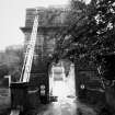
Conservation (November 2020)
Report on progress of the restoration of Union Chain Bridge, Berwick-upon-Tweed by Roland Paxton, Hon Professor, Institute for Infrastructure and Environment, Heriot-Watt University, Edinburgh, 26 November 2020
For several decades the ICE via PHEW, Heriot-Watt University, and since its formation in 2014, The Friends of Union Chain Bridge [now numbering 690] have strongly supported the preservation of Union Bridge for posterity as a world-class landmark in long span suspension bridge development. For many years now deterioration of the bridge has increasingly caused concern, to remedy which £10.5m of hard-won funding has been raised for its restoration.
On 1 July 2020 a £7.1m contract for the bridge’s restoration was entered into by the bridge owners with The Spencer Group of Hull and work on site commenced on 1st October. Completion is programmed for November 2021. Spencer’s have had experience of this kind of project as exemplified in their restoration of Sir John Rennie’s 1835 Horkstow suspension bridge, which in 1999 attracted a ‘commendation’ from the national Historic Bridge and Infrastructure Awards Panel (for which I was an adjudicator).
Because of the Covid-19 pandemic the bridge’s bicentenary on 26 July 2020 turned out to be a low key, very local, celebration which included a preview of the International Historic Civil Engineering Landmark Plaque shown below that I promised to put in train at The Friends inaugural meeting in 2014. Hopefully it will be formally dedicated in due course. Sadly, all the officially planned bicentenary engagements, including the Plaque Unveiling and Symposium, had had to be cancelled. Fortunately, the substance of the planned Symposium has survived in Spanning the Centuries published in July 2020.
The bridge’s International recognition was enhanced on this occasion by having the Japan Society of Civil Engineers as a co-sponsor of the plaque, its first association with an IHCEL Plaque.
The restoration contract is understood to be going well despite the contractor’s team having to cope with Covid-dictated restrictions. Work is now progressing on Stage 6 - the construction of towers to support winches for the removal and re-erection of the historic chains. The present state of work is indicated in the following photographs, courtesy of The Friends. It can be seen from comparing these images with Northumberland County Council’s proposed modus operandi above [Spanning the Centuries p.39], that amendments in detail have been made.
Information from: Roland Paxton, Hon Professor, Institute for Infrastructure and Environment, Heriot-Watt University, Edinburgh, 26 November 2020.

