
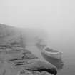
Cove Harbour


Harbour (19th Century)
Site Name Cove Harbour
Classification Harbour (19th Century)
Alternative Name(s) Cockburnspath; Heathery Heugh; North Sea
Canmore ID 58902
Site Number NT77SE 59
NGR NT 78508 71698
Datum OSGB36 - NGR
Permalink http://canmore.org.uk/site/58902


- Council Scottish Borders, The
- Parish Cockburnspath
- Former Region Borders
- Former District Berwickshire
- Former County Berwickshire
NT77SE 59.00 78508 71698
Cove Harbour [NAT]
Pier [NAT] (at NT 7853 7176)
Pier [NAT] (at NT 7850 7169)
OS 1:10,000 map, 1987.
NT77SE 59.01 NT 78464 71776 Harbour Cottage East
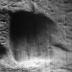
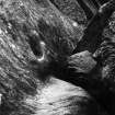
NT77SE 59.02 NT 78379 71739 Tunnel ('Mine') (NT c. 78356 71766 to NT c. 78401 71718)
NT77SE 59.03 NT 78447 71772 Harbour Cottage West
NT77SE 59.04 NT 78538 71737 to NT 78493 71778 North Pier
NT77SE 59.05 NT 78519 71718 to NT 78518 71616 South Pier
NT77SE 59.06 NT c. 78392 71718 'Cellars' (Indeterminate remains)
NT77SE 59.07 NT c. 78395 71702 Tidal cave (Indeterminate remains)
Not to be confused with Cove Harbour in Nigg parish (near Aberdeen), for which see NJ90SE 9.00.
For nearby coal mine (NT 783 718), see NT77SE 34.
For associated salmon fishers' 'bothy' (entered as Heathery Haugh, house) at S end of harbour, see NT77SE 98.
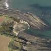
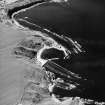
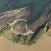
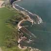
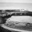
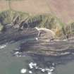
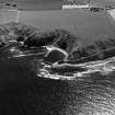
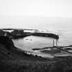
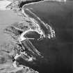
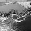
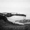
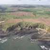
(Location cited as NT 7843 717). The inlet that now contains Cove Harbour evidently has a lengthy history as a local seaport, whether in its natural state or improved. Whitecove and Gutter's Hole were already recognised as landing-places by 1606. The ratification, in 1695, of a Dunglass charter mentions 'the Burgh of Barony of Colbrandspath [Cockburnspath] with free ports for ships and boats', probably referring to Cove and Gutcher's Holes. There are numerous references to the fishing community at Cove in the 18th and 19th centuries; a tide-waiter is mentioned in 1791. Smuggling was evidently rife along this coast in the 18th century, but had apparently been abandoned by 1834. The fishing fleet had shrunk to one salmon-coble and two lobster boats by 1963.
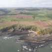
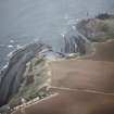
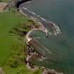
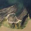
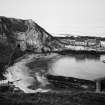
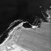
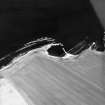
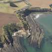
The N side of the inlet is protected by a descending bluff which provides, at its E end, a base for the N pier. A road from Cove village (NT77SE 78) to the pier has been terraced along its steep outer face. Its inner face consists of natural rock, and cuts off access to the pier from the rest of the inlet except at Low Water, and increases in height to the SW, forming a cliff. Some 90 yds [82m] from landward end of this pier, this cliff-face strikes inland (towards the SW), and its place is taken by a beach of shingle and sand; this curves SE and extends to the S pier. This beach is backed by a high and very steep grassy slope, largely formed of clay and liable to slippage; is base is subject to erosion by exceptionally high tides. The cliffs resume E of the S pier.
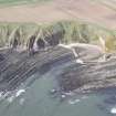
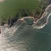
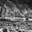
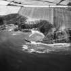
The rocks are sandstones and shales, with some 'foul' coals of Lower Carboniferous age. Their E-W strike and steep Northerly dip have led to the formation through differential erosion of a system of channels and jagged ridges, which are noted on OS maps as the 'Shore Goats' and are exposed at Low Water. A lane of deeper water (which does not dry at Low Water Ordinary Springs) penetrated this area almost as far as the present harbour entrance NT 7853 7172]. The sandstone that forms the bluff N of the harbour is soft, and would be easy to work with a pick; that beyond the S pier is harder but still relatively easy to work. Caves have formed at sea level, as erosion follows lines of least resistance.
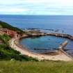
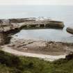
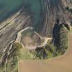
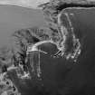
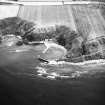
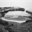
The present harbour was completed in 1831, after storms had wrecked the unfinished works of the earlier projects. It extends to just over 3 acres [1.2ha] and formerly accommodated craft of up to '60 tons burden'; the entrance, 72ft [22m] wide, was regarded as too wide. A heavy seas is thrown into the harbour in stormy conditions, while rocky ledges and sunken rocks form dangers off shore. Nevertheless, this harbour is larger than those at Skateraw (NT77NW 69) and St Abbs (NT96NW 54.00).
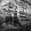
The first of the two unsuccessful projects must rank as a significant essay in 18th century improvement. In about 1744, Sir John Hall of Dunglass attempted to 'clear a bason' and 'make a harbor' at Cove. Construction of the wall was 'considerably advanced' when a strong wind from the NE raised a sea of sufficient power to destroy the works, which were not restarted. A road was cut through the rock for a distance of about 60 yards [55m], while 'cellars' were cut out of the rock. These were said to be 'useful and commodious', and were probably partly of natural origin.
The OS Name Book notes the name 'The Boyne', which appears on the 1st edition of the OS 6-inch map as applying to an earlier ('original') harbour 'for fishermen in the neighbourhood in Cockburnspath'. This suggests that whatever small tidal may have existed before the improvements may have been obliterated by the landward end of the S pier, and by the sand and gravel that accumulated on either side of it.
Harbour remains
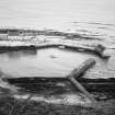
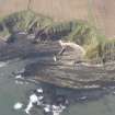
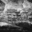
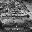
The surviving remains of these works may be summarised. The 'wall' that is mentioned in the Statistical Account is readily located in the tidal area just E of the S pier, within the area where Roy's Map depicts a breakwater. The cliffs here rise steeply from the foreshore, their bases being just above High Water Mark at the S pier and dropping to some 3 or 4 feet [0.9 or 1.2m] below it along a frontage of about 150ft [45.8m]. For 24ft [7.3m] Eastwards from a point 112ft [34.1m] E of the pier the rock-face is heavily marked with step-like ledges, which were evidently cut as tusking for the dressed slabs and blocks of masonry. The assemblage comprises two flights of these ledges, main and lateral. The latter flanks the former on the E; the narrowness and depth of the ledges suggest that they were intended to take the ends of horizontal facing-slabs. The main flight ranges in length from about 3ft [0.9m] below to about 7ft 6ins [2.3m] above High Water Mark; the largest ledge is 8ft [2.4m] long and has been cut back at least 1ft 2ins [0.36m] in one corner. The lateral flight rises about a foot higher; its top ledge is 3ft [0.9m] wide by 2ft 2ins [0.66m] deep at one end, but the lower-most holes, which are much waisted, have probably been the largest. Beside the lowest one, a hole 5ins [127mm] has been sunk, perhaps for an iron stanchion. The tusking is flanked on the W (on the other side of a fissure) by two flights of cuttings ('steps') of a similar character. These rise to about the same height as the tusking, and are pretty certainly stairs for access to the top of the structure. Rock-cut stairs of this type, although now repaired and altered, can be seen leading up from the tidal basin of the harbour to the footway of the N pier at a point just the houses, where also another flight (unaltered) rises to the top of the parapet, which is itself cut out of the rock. Others again occur at a coastal quarry NW of the Bilsdean Burn (Standalane Otter Hole: NT 7645 7295) giving access to the working faces
That the structure received on the tusking was in fact a breakwater is proved by foundations on the foreshore. Immediately below the main flight, a kerb of largish stones has been set along the base of the cliff, and outside this a deposit of irregular cobbling. Again, about 20ft [6.1m] out from the cliff and extending outwards for a further 18ft [5.5m] as far as the first transverse rock-ridge, there is a well-defined strip of cobbling carefully kerbed with blocks along its western edge. Its eastern (or seaward) edge has been eroded by the waves, but a breadth of from 11ft [3.4m] to 13ft [4m] can be measured. The original breadth here may have been about 18ft [5.5m] but there are some signs that the western edge curved out to coincide with the end of the tusking, which would have made the breadth at the cliff-face about 24ft [7.3m]. This causeway-like setting was evidently the foundation of the breakwater's core, the stonework, and in particular any dressed facing-blocks, having no doubt been removed both from here and from other parts of the structure for re-use in the existing piers. Further traces of the breakwater are to be seen in two deposits of very large boulders, thinly scattered to a breadth of about 20ft [6.1m] which occur between the second and third, and again between the third and fourth, ridges of tidal rocks, about 82ft [25m] and 103ft [31.4m] (centres) respectively from the base of the cliff; these deposits are aligned with the causeway and tusking, and no doubt represent the heavy bottoming required where the water was deep at high tide and the force of the waves considerable. The second and third rock-ridges both show traces of battering at a few points, as if in preparation for masonry, but beyond the outer deposit of boulders nothing can be seen. The original length of the breakwater, as built or begun, must thus have been well over 100ft [30.5m].
Whether, or how much of, this structure should be attributed to Sir John Hall must naturally remain in doubt; but the statement that 'the present' pier was built upon another plan' implies that the two earlier breakwaters shared the same 'plan' and suggests that they occupied the same site. If they did so, the existing remains may well represent both, combined in a such a way as precludes differentiation. The idea that work of two periods may be present on the same site would do something to account for the double flight of steps.
Before leaving the subject of the breakwaters, it is necessary to deal with some further further traces of construction which appear a short distance to the W. Close to the base of the cliff, and 42ft [12.8m] E of the S Pier, a small patch of masonry blocks sometimes appears through the shifting surface of the sand, one of them apparently dislodged from a cavity cut for it in the rock below; while to seaward three transverse rock-ridges have been notched, evidently for masonry foundations. The notch in the innermost ridge has been battered to a width of 6ft [1.8m] with its centre 59ft [18m] out from the cliff; while the corresponding notch in the next ridge, centred 18ft [5.5m] further out, has had its bottom neatly squared to a width of 5ft [1.5m] and a depth of 7ins [178mm]. Immediately beyond this second notch, a cavity has been cut in the rock to fit the end of a dressed slab. The third notch is centred 28ft [8.5m] beyond the second, but is 10ft [3m] E of the line on which lie the others and the squared stone blocks. These notches point clearly to some masonry structure, but its nature is difficult to guess. Its thinness and curving alignment, and the absence of any tusking on the cliff-face, suggest that it was something other than a protective breakwater, yet its position among the dangerous tidal ridges would seem to make it useless as a jetty. Whatever its purpose, it may be older than all the improvements and be connected with the Boyne. With this structure should perhaps be associated, as evidence for the working of boats on this part of the shore, an iron ring let into the cliff 12ft [36.7m] E of the S Pier.
A final feature of this area which calls for notice is a line of footholds cut in the face of the cliff. They cross the face horizontally, about 6ft [1.8m] above high-water mark, and, after passing a fissure, turn upwards to finish near the top of the flights of steps. Below them the face of the rock seems to have been cut back. Similar footholds descend from the top of the lateral flight of tusking, and these can be followed eastwards, in close association with a narrow natural ledge at a point where one has been cut to ease passage past an obstruction. They were probably intended for the use, when the tide was high, of men working on the breakwater or on boats laid in at the base of the cliff. Beyond the end of the ledge just mentioned, a narrow pathway has been broken or worn along or across the low tidal rock-ridges of another inlet E of the Hollow Rock, a fact which points to considerable foot-traffic to the harbour from further along the coast.
The remaining works attributable to the 18th century are mentioned in one or another of the Dunglass records. The 'road from Cove' was no doubt an earlier version of the road that now leads down to the North Pier; but this can hardly represent the original as it must have been constantly repaired, if not actually rebuilt, in the course of two centuries. This is made the more likely by the instability of the hillside both above and below the road, which was once, in fact, temporarily blocked by a landslip in 1963. The 'Gutt', the first item in the Redpath memorandum, was probably the natural channel that still gives access to the existing harbour; both the word itself and the dimensions given in the memorandum suggest some kind of passage, while a depth of 2ft [0.6m], in particular, would suit the deepening of a navigable channel. Search for traces of work on this line is frustrated by the sand and seaweed that cover the bottom of the harbour. The figures given in the memorandum as relating to the 'Gutt' are not consistent with themselves; the stated dimensions work out to 50.3, not 51, cubic fathoms, and though, at the 10s rate the price of £25 is approximately right for the 50.3 cubic fathoms, 51 cubic fathoms should presumably have been priced at £25 10s.
After the 'mine' (tunnel) and the 'cellars', the last major item in the Redpath memorandum is the 'Corner'; no physical remains can be cited to suggest its nature or position. The comment that it was 'esteemed 11 fathom, but far too much' suggests that its shape may have been too irregular for measurement, and it may therefore perhaps have been some rocky projection which obstructed building or road-work. The large recess in the cliff-base by the salmon-fishers' bothy (NT77SE 98, at S of harbour) might fit the description as a 'corner' but should not have been impossible to measure. The job was priced at £5 10s 0d.
The foregoing account of the earlier harbour-works has pointed to nothing analogous with the North Pier (NT77SE 59.04). It seems likely that the whole of this latter structure, including the landward section with its remarkable rock-cut parapet, was built new in 1830, as the pier-head is known to have been. Sir John Hall, on this showing, like all earlier users of the inlet, must have looked for protection from the northerly winds to the tidal rocks on which much of the North Pier is founded.
A Graham 1966.
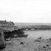
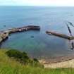
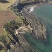
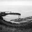
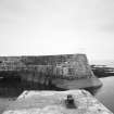
(Location cited as NT 784 717). Cove, Berwickshire. Cove Harbour occupies a tidal inlet among rocks, open to the E, but enclosed on the S, W and NW by high cliffs, and partially protected on the N by a massive cliff-bound bluff. The inlet has a longish history as a seaport, as it seems to have been a recognised landing-place at least as early as the beginning of the 17th century. In the 1750's, and again in the 1820's, attempts were made to build a harbour, but in each case the works were wrecked by storms before completion. The existing works, which were finished in 1831, consist of two piers, a northern one extending SE-wards from the end of the bluff just mentioned and a southern one running northwards from the S arc of the bay. The enclosed area amounts to just over 3 acres [1.2 ha], and the whole of it dries out at low water as far as the entrance which is at the low-water head of a channel running through the tidal rocks, was perhaps deepened artificially in 1751, and is 72ft [21.9m] wide between the ends of the piers.
Both piers are built of light-red, grey and yellowish sandstone blocks, very well cut and coursed, with iron strapping, 2ins [51mm] wide by 1in [25mm] along the edges of upper surfaces and on external angles. Bedding in the underlying rock for the foundations of the lowest-lying parts was extremely difficult to cut, as work was only possible at the bottom of the lowest tides and then only for very short spells.
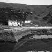
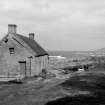
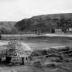
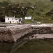
The North Pier (NT77SE 59.04) is angled, its outer portion being 70ft [21.3m] and its inner one 140ft [42.7m] externally; it carries a walkway 13ft 6ins [4.1m] wide, about 9ft [2.7m] above high water mark, and a parapet 9ft 2ins [2.8m] and 5ft [1.5m] thick on top. A flight of steps mounts the parapet at the angle, and a wider one at the end. Just below the lip of the walkway 17 pairs of round-ended stones project, like corbels, from the face of the pier; they were probably intended to keep in place the mooring-ropes of craft lying below. At the end of the walkway there is a double iron pawl, and one stone and three wooden ones elsewhere along its length; also several iron mooring-rings and remains of the attachments of others. At its landward end, the walkway widens into a shelf cut out of the rock, protected on its seaward side by a ridge, left uncut, which prolongs the parapet landwards and may originally have carried some continuation of its coping. On the shelf, there stand two houses inhabited until 1946 but now used as stores, and from it rock-cut steps give access both to the top of the unexcavated rock and, at low water, to the bottom of the harbour. At high water there is no land access to the rest of the harbour area except by a tunnel (NT77NE 59.02) through the cliffs, itself reached from the pier by a road which mounts the seaward face of the bluff.
The South Pier (NT77SE 59.05) projects from a cliff on the E side of the bay, and stretches across a flattish area of tidal rock-ridges and channels. It consists of two sections set an angle, the outer one being much the stouter; neither has a parapet, and they seem to have been primarily breakwaters. The outer section is 155 yds [141.2m] long by 12ft 3ins [3.7m] wide on top; it is paved with large slabs, partly replaced by cement, and where the surface is broken a rubble core appears. At the end it carries one wooden and two iron pawls, but no rings. The inner section, which is built of smaller blocks than the outer, is 170ft [51.8m] long by only 4ft [1.2m] wide on top. It is secured with longitudinal iron straps and also with transverse hoops, of which latter seventeen are still in position. Its landward end, close to the cliff, is crossed by steps, and carries a mooring-ring and an iron stanchion.
Thirty-eight yards E of this pier, there can be seen, cut in the cliff-face, two flights of step-like ledges, evidently tusking for the squared blocks and slabs of a masonry structure. This tusking is flanked on the W by two flights of cuttings of a different character, which seem to be stairs for access to the top of the structure; while further to the W again there appears a horizontal row of footholds. Proof that the structure received on the tusking was in fact a breakwater - or, more probably, two successive breakwaters corresponding with the two abortive projects mentioned above - is provided by cobble foundations between the cliff-face and the first of the transverse ridges of tidal rock, as well as by scatters of large stones between the second and third and the third and fourth ridges, presumably remains of the heavy bottoming required in deeper water.
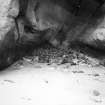
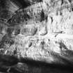
The most interesting features of this site are not the harbour-works themselves, but the access tunnel (NT77NE 59.02) that pierces the bluff on the W side of the bay, and the system of cellars (NT77SE 59.06) cut in the rock alongside. The tunnel is 183ft [56m] long, and wide and high enough for carts; the cellars comprise a main passage 114ft 3ins [34.8m] long by up to 10ft 6ins [3.2m] wide, a series of four lateral cellars measuring in respective length, with their entrance-passages 55ft 6ins [16.9m], 49ft [14.9m], 42ft [12.8m] and 21ft [6.4m], and a small chamber just inside the entrance. The entrance has been blocked by landslides, but access may be obtained by a passage broken out to the tunnel in 1830. The purpose of the cellars is not recorded, but they are likely to have had some function in the storage or processing of fish.
A Graham 1971.
(Location cited as NT 785 717). Cove Harbour, Cockburnspath, 18th century. Two piers, one of them straight, the other with an angled head, protecting a bay. There are ruins of two-storey cottages on the angled-head pier. A tunnel through a headland provided access to the shore of the bay.
J R Hume 1976.
Cove Harbour. Entered by a 55m tunnel from the cliff path. A landing-place in the 17th century, if not earlier, the harbour form remains that of 1831, by which time at least two earlier ones had succumbed to the elements. Cove was one of the great romantic experiences until the headland was removed. The fishermen's cottages are built off the rock, from the sea at low tide atop a boiling rock formation. Caves in the cliffs hold tales of smuggling, but may also reflect the existence of coal seams.
C A Strang 1994.
Project (2007)
This project was undertaken to input site information listed in 'Civil engineering heritage: Scotland - Lowlands and Borders' by R Paxton and J Shipway, 2007.
Publication Account (2007)
Cove Harbour, now little used, was completed in 1831. It has two masonry piers forming an entrance about 50 ft
wide with the North Sea and enclosing an area of three acres. Earlier piers, vestiges of which still exist, were
destroyed in storms, but a notable tunnel made through a spur of rock in ca.1752 remains, although somewhat
distorted in parts by recent safeguarding measures. It was formed as part of a harbour improvement by Sir
John Hall of Dunglass to give safe access to the beach (see NT77SE 59.02).
R Paxton and S Shipway 2007
Reproduce from 'Civil Engineering heritage: Scotland - Lowlands and Borders' with kind permission of Thomas Telford Publishers.
Field Visit (2014)
The harbour at Cove occupies a tidal inlet enclosed on three sides by high cliffs. It has a long history as a landing place and port. The present harbour works date to the early-mid 19th C and comprise of one straight and one angled pier, enclosing the bay. Land access to the bay is gained via a tunnel cut through the headland. The harbour remains in use. Two single storied cottages stand on the angled pier. Of late 18th- early 19th C date, the cottages are now ruinous and unoccupied: both are listed. Two seasonally occupied house stand at the east end of the bay.
Visited by Scotland's Coastal Heritage at Risk (SCHARP) 2014
Field Visit (27 October 2015)
ShoreUPDATE 27-10-2015:
As described. There is a modest rock armour coastal defence defending the coast edge on the seaward end of the tunnel.
The harbour walls are generally sound, although there is some evidence of erosion of the mortar and sandstone. Part of the harbour wall is carved from sandstone bedrock. The harbour is in use.
The pair of cottages on the harbour wall are in better condition than described. They have new chimneys, sound roofs and are weather tight. Both are used for storage.
Visited by Scotland's Coastal Heritage at Risk (SCHARP) 2015
Sbc Note (15 April 2016)
Visibility: Standing structure or monument.
Information from Scottish Borders Council

