
Cove, Harbour, Coal Mine


Coal Mining Site (17th Century)
Site Name Cove, Harbour, Coal Mine
Classification Coal Mining Site (17th Century)
Canmore ID 58875
Site Number NT77SE 34
NGR NT 783 718
NGR Description NT c. 783 718
Datum OSGB36 - NGR
Permalink http://canmore.org.uk/site/58875


- Council Scottish Borders, The
- Parish Cockburnspath
- Former Region Borders
- Former District Berwickshire
- Former County Berwickshire
NT77SE 34 c. 783 718
See also NT77SE 59.00.
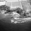
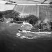
NT c. 783 718. Clearing operations are being carried out in a 17th century coal mine, on a N-facing beach, 100 yds W of Cove harbour (NT77SE 59.00). The mine is made up of two horizontal levels and four vertical shafts, three of which descend below sea level. Two horizontal levels are joined by a rock-cut stairway 60ft below ground level and 195ft in from the beach.
G R Haggarty 1974.
Sbc Note (15 April 2016)
Visibility: Standing structure or monument.
Information from Scottish Borders Council

