
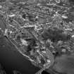
Kelso, General


Burgh (Medieval), Town (Period Unassigned)
Site Name Kelso, General
Classification Burgh (Medieval), Town (Period Unassigned)
Canmore ID 58448
Site Number NT73SW 44
NGR NT 72758 33983
NGR Description Centred NT 72758 33983
Datum OSGB36 - NGR
Permalink http://canmore.org.uk/site/58448


- Council Scottish Borders, The
- Parish Kelso
- Former Region Borders
- Former District Roxburgh
- Former County Roxburghshire
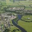
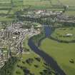
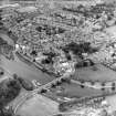
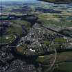
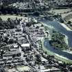
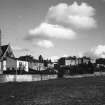
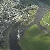
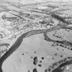
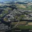
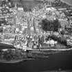
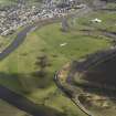
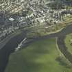
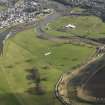
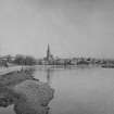
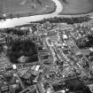
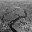
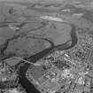
Kelso lies at the confluence of the Rivers Tweed and Teviot, occupying a chalky hill and it is from this that the town's name is derived, having been known originally as Calchou. Today the burgh is well known for its large, continental-style main square and the quantity of Georgian buildings still visible throughout the town. Their survival is probably a result of Kelso not sharing in the great mill boom of the nineteenth century that brought an influx of workers to the other Borders burghs.
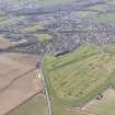
Throughout the Middle Ages, there were two settlements named Kelso: Wester Kelso, a burgh which probably stood somewhere to the west of the gates into the Floors estate, and Easter Kelso, a village or 'toun' that stood somewhere to the north-west of the abbey. Wester Kelso appears to have declined at the same time as Roxburgh, during the long English occupation of the castle, and was largely destroyed in a late seventeenth-century fire. Easter Kelso expanded throughout the Middle Ages along what is now Roxburgh Street, and became the modern burgh of Kelso.
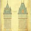
Until the late sixteenth century, life in Kelso was largely under the control of the abbey, which was both a spiritual focus as well as landlord to the townspeople. The magnificent western transept, surviving to almost its original height, gives a sense of the abbey's imposing scale, and even as the abbey's wealth declined in the early sixteenth century it remained an impressive building according to contemporary accounts. After the Reformation, the abbey's interests in and around Kelso became the property of the Kers of Cessford, ancestors of the Dukes of Roxburghe and by the seventeenth century, the Kers effectively owned Kelso.
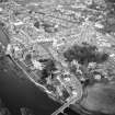
Other than the abbey itself, little remains of medieval Kelso. Serious fires in 1645 and 1685 appear to have swept away many of medieval buildings in the town. In the following century however, there was considerable rebuilding, with several notable improvements being made. In 1670, Kelso Grammar School was formally established (although it seems likely that the old monastic school had probably continued informally), a subscription library opened in 1750, and in the 1770s a public dispensary and hospital was created. The building of the first bridge over the River Tweed in the 1770s opened up Kelso to the Edinburgh to Newcastle coaches and other passing trade. This bridge was destroyed by a flood in 1797, and replaced by the present bridge, designed by John Rennie, in 1800-3. By the 1820s, Kelso had three coaching inns, including the Cross Keys which dominates one side of The Square.
However, the seventeenth and eighteenth centuries were also a time of revolutions and uprisings, and Kelso played its small part in the upheavals troubling the nation. In the 1640s, a Covenanting force took possession of the town, while the Jacobites easily captured Kelso in the uprisings of 1715, when the Highlanders gathered with townspeople at the market cross of Wester Kelso to hear the Hanoverians denounced and the Old Pretender proclaimed as their rightful king. Thirty years later in 1745, Bonnie Prince Charlie resided in the Chatto Lodging House, a building which stood on the site of Ednam House. However, contemporary records seem to suggest that the Kelsonians of the day were rather indifferent to the Jacobite cause, as no one seems to have willingly joined the Young Pretender's army.
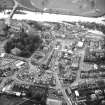
The late eighteenth and nineteenth centuries was a time of considerable building in Kelso. Many of the existing buildings in the town centre were constructed at this time, and the town began to expand, largely by the building of middle-class houses. Walking along Roxburgh Street, this outward growth is evident. Near the centre of Kelso, lofty tenements rise on either side of the narrow street. Further to the north, the tenements give way to terraced houses and detached villas, many of these being sited for their views over the River Tweed, while the street itself broadens. Similarly, many of the houses on Edenside Road date from this period of expansion, while the modern housing on Grovehill occupies the site of a large villa and its grounds.
Despite this impressive growth and development, Kelso remained a burgh of barony and the effective possession of the Dukes of Roxburghe until 1853. In December of that year a petition was circulated supporting a move to make Kelso a Police Burgh, where a dozen elected Police Commissioners oversaw its affairs. In 1892, under the Burgh Police Act, they became the Burgh Council under the leadership of a Provost elected from their number.
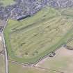
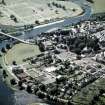
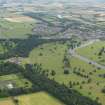
Having played no part in the textile boom of the nineteenth century, Kelso remained a market town with an economy which was largely agricultural and service-based. In the 1960s, the government introduced a series of initiatives to develop the Scottish economy. As a result, Kelso Town Council embarked on an ambitious building programme, erecting modern council housing while developing part of the old Pinnaclehill estate in Maxwellheugh as an industrial estate, currently occupied by knitwear and electronics businesses. Springwood Park, once home to the Douglas family, was partly demolished in the 1960s, with the parkland sold off. Part of the estate is now a caravan park. The most recent development for Kelso is the construction of Hunter's Bridge, designed to reduce the pressure of traffic on Rennie's bridge.
Text prepared by RCAHMS as part of the Accessing Scotland's Past project
NT73NW 44 centred 72758 33983
For burgh of West Kelso (NT 719 343), see NT73SW 51.
EXTERNAL REFERENCE:
Edinburgh Public Library
Scots Magazine, February 1810 - 1 Engraving
(Undated) information in NMRS.
At time of entry the exact location of Kelso WaterTower could not be determined.
It is not possible at time of entry to establish in which church the memorial to Charles Barrington Balfour (Collection items LOR/B/47/1 and LOR K/16/1) is located.
Information from RCAHMS (AC), 8 April 2002.
Photographic Survey (1955)
Photographic survey by the Scottish National Buildings Record in 1955.
Sbc Note
Visibility: This is an upstanding building.
Information from Scottish Borders Council.

