
Wooden Mill


Woollen Mill (Period Unassigned)
Site Name Wooden Mill
Classification Woollen Mill (Period Unassigned)
Alternative Name(s) River Teviot
Canmore ID 145988
Site Number NT73SW 116
NGR NT 7375 3413
Datum OSGB36 - NGR
Permalink http://canmore.org.uk/site/145988

- Council Scottish Borders, The
- Parish Kelso
- Former Region Borders
- Former District Roxburgh
- Former County Roxburghshire
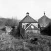
Wooden Mill lies about 500m north-west of Wooden House, built by the banks of the River Tweed overlooking Wooden Anna. The mill appears on Tennant's Map of Roxburghshire published in 1840, and was probably built shortly before.
The mill was photographed in 1974 and at this time the buildings were near-ruinous. The mill's pyramidal-roofed kiln was intact, though the mill building itself lay in ruins. According to the first edition of the Ordnance Survey 6-inch map of Roxburghshire (1860) this was a woollen mill, and the map clearly shows that the mill was sited to exploit the stream running around the south bank of Wooden Anna.
Text prepared by RCAHMS as part of the Accessing Scotland's Past project
NT73SW 116 7375 3413
Wooden Mill [NAT]
OS 1:10,000 map, 1993.
For associated weir, see NT73SW 283.
(Location cited as NT 738 342). Wooden Mill, early 19th century. Now largely ruinous, with an intact pyramidal-roofed kiln. Was a woollen mill in 1859.
J R Hume 1976.

