
Littledean Fort


Fort (Period Unassigned)
Site Name Littledean Fort
Classification Fort (Period Unassigned)
Alternative Name(s) Littledean Tower
Canmore ID 57266
Site Number NT63SW 51
NGR NT 6324 3129
Datum OSGB36 - NGR
Permalink http://canmore.org.uk/site/57266


- Council Scottish Borders, The
- Parish Maxton
- Former Region Borders
- Former District Ettrick And Lauderdale
- Former County Roxburghshire
Project (1993)
NT63SW 51 6324 3129
See also NT63SW 16.
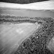
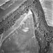
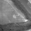
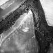
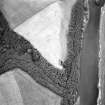
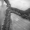
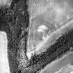
NT 632 313. In 1993 K Clark from the Newstead Research Project surveyed Littledean. This fort is recorded in the NMRS as site NT63SW 51. Resistivity results show evidence for a promontory enclosure comprised of at least three irregularly spaced ditches. Magnetometry results produce evidence for at least five enclosing ditches.
Littledean Tower (NT63SW 16) sits within all of these earthworks.
Sponsors: National Museum of Scotland, University of Bradford, British Academy, Borders Regional Council
A L Wise 1995.
Magnetometry (1993)
NT 632 313. Magnetometry survey.
A L Wise 1995.
Resistivity (1993)
NT 632 313. Resistivity survey.
A L Wise 1995.
Note (3 September 2015 - 19 October 2016)
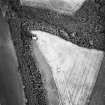
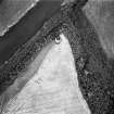
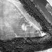
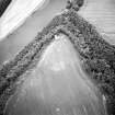
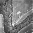
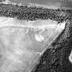
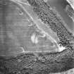
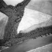
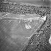
Cropmarks have revealed that the ruin of Littledean Tower, a tower-house of 16th century date (RCAHMS 1956, 261-2, no.558), stands within a promontory enclosure. The tower occupies the E end of the promontory, which is formed between the steep-sided Little Dean on the SE and the bluff above the S bank of the River Tweed on the N. Access from the WSW, however, where the ground drops gently into the promontory, has been barred by no fewer than four ditches, though they may represent several separate phases of construction. The innermost ditch, for example, which cuts off an area measuring at least 140m from ENE to WSW by 115m transversely (1ha), is not strictly concentric to the the pair outside it, converging towards the S, and while it is between 2m and 3m in breadth, these other two are in the order of 4m in breadth. Likewise the fourth, outermost, ditch is not only much narrower but is drawn on an altogether shallower arc. In addition an unpublished geophysical survey has identified a fifth ditch (Wise 1995). There is a possible entrance through the middle pair of ditches on the SW, close to the SE margin of the promontory, but, there are faint traces of the innermost ditch carrying across the gap. Apart from the tower-house in the interior, the cropmarks include several elongated features that are as likely to mark the positions of rectangular buildings as the stances of round-houses. The RCAHMS investigators recording the tower-house in 1932 noted that there 'seems to have been a barmkin', but without elaborating on the source of this comment. The presence of a barmkin associated with the tower-house might account for some of the earthworks, but it is probable that they also include the remains of an earlier promontory fort.
Information from An Atlas of Hillforts of Great Britain and Ireland – 19 October 2016. Atlas of Hillforts SC3397
Sbc Note
Visibility: This site is visible as a cropmark.
Information from Scottish Borders Council

