
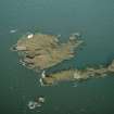
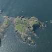
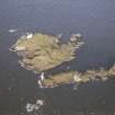
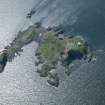
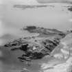
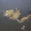
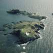
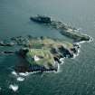
Fidra, St Nicholas Church And Burial-ground


Burial Ground (Medieval), Church (Medieval)
Site Name Fidra, St Nicholas Church And Burial-ground
Classification Burial Ground (Medieval), Church (Medieval)
Canmore ID 56636
Site Number NT58NW 1
NGR NT 5127 8689
Datum OSGB36 - NGR
Permalink http://canmore.org.uk/site/56636


- Council East Lothian
- Parish Dirleton
- Former Region Lothian
- Former District East Lothian
- Former County East Lothian
NT58NW 1 5127 8689.
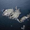
(NT 5127 8689) St Nicholas's Church (NR) (remains of)
OS 6" map (1971)
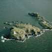
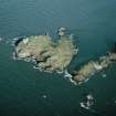
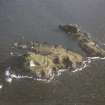
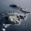
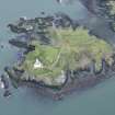
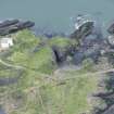
St Nicholas's Church on Fidra probably dates from the early 13th century. Oriented E-W, it is rectangular on plan, 20 1/2ft broad, and comprises a nave and chancel, 39 1/4ft and 19ft long respectively, separated by an arch. The gables were 3ft, and the later walls 2 3/4ft, in thickness. Only the N wall now remains; the others can be traced only by their foundations. The former is some 12ft to 15ft in height and a length of 44ft still stands; it contains a lancet window, a small, roughly finished window, and what appears to have been a round-arched door. Other foundations run in a southerly direction towards the creek from the W end of the building. Green states that this church was dedicated in 1165. (See also NT58NW 26).
RCAHMS 1924, visited 1913; C Green 1907
Only a portion of the N wall, 13.5m long, about 4.0m high, and containing the architectural features described by the RCAHMS, remains. The footings of the rest of the church are covered by a turf mound 0.3m high.
The course of the graveyard wall can be followed by a line of ambedded stones. Some obscure depressions abutting outside the W wall of the graveyard may indicate the sites of buildings associated with the establishment; they are not surveyable.
Visited by OS (JLD) 14 May 1965.
Early 13th century church. Only the N wall now remains, the others are only seen as foundations. The grave yard wall can be seen by a line of embedded stones and there are possible structures abutting the west wall.
Site recorded by GUARD during the Coastal Assessment Survey for Historic Scotland, 'The Firth of Forth from Dunbar to the Coast of Fife' 1996.
Field Visit (4 August 1913)
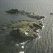
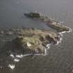
Situated on the east side of the Island of Fidra, above the landing stage, are the remains of a church. The structure is orientated and has been double chambered, combining choir and sanctuary of equal widths. The sanctuary has been some 19 feet long and separated by an arch 2 ¾ feet thick from the choir, which was 39 ¼ feet in length. The span of the structure is 20 ½ feet. The gables have been 3 feet and the lateral walls 2 ¾ feet in thickness.
Only the north wall now remains; the others can be traced solely by foundations. The former is some 12 to 15 feet in height and a length of 44 feet is still standing. It is built of igneous rock irregularly coursed with grey sandstone dressings. In the north wall of the 'sanctuary there is a lancet window 1 foot 4 inches wide with an obtusely pointed head and semi-circular scoinson arch; a splay is wrought on the jambs. An aperture at the western end appears to have been a round arched north door. West of this is a small roughly finished window. The structure probably dates from the early 13th century. From the west end of the building other foundations run in a southerly direction towards the creek.
HISTORICAL NOTE. The church in Fidra or ‘island of Elbotle’ was dedicated to St. Nicholas and served by the canons of Dryburgh. In the reign of William the Lion (c. 1170) William de Vaux (cf. [RCAHMS 1924] No. 27 [Dirleton Castle]) granted to it the patronage of the church at Gullane, and the grant was confirmed by his son John. A later William c. 1220 made a grant to the canons of the island itself, with land in the ‘territory of Elbotyle’ on the mainland immediately opposite. Two canons were understood to reside and celebrate on the island. But about 1240 Alexander de Vaux ‘in consideration of the imminent dangers of times present and to come’ released Dryburgh from the necessity of maintaining that chantry (illam cantariam) as hitherto on the island itself, or of building or sending canons to live on it. Instead a canon was to be provided at ‘Stodfald’ on the mainland and another in Dryburgh to pray for the souls of this de Vaux' ancestors and successors (1). It does not seem, therefore, that the building was ever completed.
RCAHMS 1924, visited 4 August 1913.
(1) Liber de Dryburgh passim.

