
Broadhaugh Hill


Settlement (Period Unassigned)
Site Name Broadhaugh Hill
Classification Settlement (Period Unassigned)
Canmore ID 54009
Site Number NT40NE 10
NGR NT 4523 0831
Datum OSGB36 - NGR
Permalink http://canmore.org.uk/site/54009


- Council Scottish Borders, The
- Parish Teviothead
- Former Region Borders
- Former District Roxburgh
- Former County Roxburghshire
NT40NE 10 4523 0831.
(NT 4523 0831) Earthwork (NR)
OS 25" map (1968)
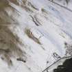
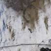
This earthwork stands on a spur 270 yds W of the summit of Broadhaugh Hill at a height of about 870ft OD. Sub-rectangular on plan, it measures 150 ft from NE to SW by 115 ft transversely within a low earthen bank, the material for which has come from an intermittent external ditch, which is now completely filled in on the SE side, but at the NE end, where it is best preserved, it is 14ft wide and 2 1/2ft deep. There is a well-defined entrance, 17ft wide, in the SW end, but apart from a scooped area on the NW the interior is featureless. A later field boundary runs across the NE end of the site.
RCAHMS 1956, visited 1948
This earthwork is as described above. The enclosing bank is best preserved at the NE end where it has an external height of 1.3m and an internal height of 1.1m.
Revised at 25".
Visited by OS (WDJ) 22 February 1965
No change in condition. The location and size of this work suggests that it is a settlement, with the scoops in the NW of the interior forming at least two probable hut platforms.
Surveyed at 1:10,000.
Visited by OS (JRL) 13 December 1979
Sbc Note
Visibility: This is an upstanding earthwork or monument.
Information from Scottish Borders Council

