
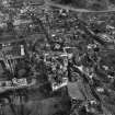
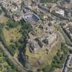
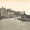
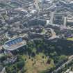
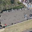
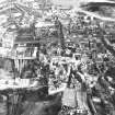
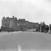
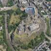
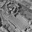
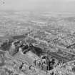
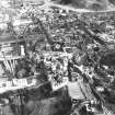
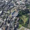
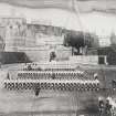
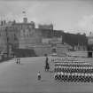
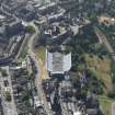
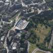
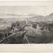
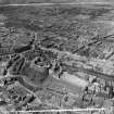
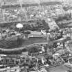
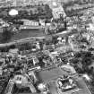
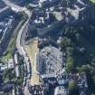
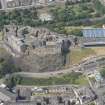
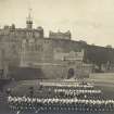
Edinburgh Castle, Esplanade


Esplanade (20th Century)
Site Name Edinburgh Castle, Esplanade
Classification Esplanade (20th Century)
Canmore ID 111664
Site Number NT27SE 1.33
NGR NT 25318 73502
NGR Description Centred NT 25318 73502
Datum OSGB36 - NGR
Permalink http://canmore.org.uk/site/111664


- Council Edinburgh, City Of
- Parish Edinburgh (Edinburgh, City Of)
- Former Region Lothian
- Former District City Of Edinburgh
- Former County Midlothian
NT27SE 1.33 centred 25318 73502
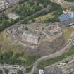
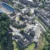
NT 253 734 A watching brief was carried out in January 1998 on work on the S side of the Esplanade. The slope as seen today is likely to be highly artificial, although in a limited number of areas bedrock can be seen. This is a yellow sandstone, forming part of the 'tail' of the crag-and-tail formation that the Castle and High Street sit on, representing soft deposits shielded from the glacial scouring by the hard basalt of the Castle Rock. In 1753 spoil from the construction of what is now the City Chambers was used to level off the area, to form a parade ground, an arrangement formalised between 1816-20, when the Esplanade as it stands today was constructed. A number of walls are visible through geophysical survey running across the slope, presumably built as retaining walls, which may relate to either of these phases of construction, or to other undocumented work. It should be noted that no walls are shown on the 1877 OS map, although areas of bedrock are clearly shown.
Excavation of four test-pits showed evidence for a surprising depth of deposits (1.2-2.3m+) across this slope. This material is almost all likely to represent 18th-century or later landscaping, raising the possibility that medieval features may survive underneath, if use was made of this area in that period. It was not possible to relate any of the upstanding revetting walls encountered to any of the excavated areas, but it seems likely, on cartographic grounds, that they all post-date 1877.
Sponsor: Historic Scotland
D Murray 1998.
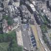
NT 2537 7352 The Esplanade. A watching brief was carried out in October 1999 on two holes dug for the siting of a new notice board in the NE corner of the castle esplanade, immediately to the E of the ticket caravan. The westernmost trench removed an anchor point for the Tattoo scaffolding. The main deposits seen were thought most likely to be levelling material imported during large-scale changes to the esplanade, of unknown but relatively recent date.
Sponsor: Historic Scotland
A Dunn 2000.
NT 254 735 A watching brief was required between March and May 2005 during the installation of electrical supplies around the S, E and N perimeters of Edinburgh Castle Esplanade (NT27SE 5). The watching brief confirmed that a substantial depth of relatively modern material, probably deriving from the 18th century onwards, forms the level ground of the esplanade. No other significant archaeology was encountered.
Archive to be deposited in NMRS.
Sponsor: City of Edinburgh Council.
L Scott, E Bailey 2005
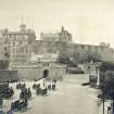
INFORMATION FROM A CATALOGUE SLIP
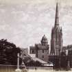
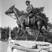
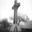
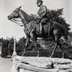
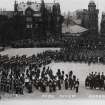
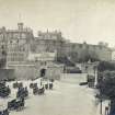
The Earl Haig Monument was created in 1923 by the sculptor G Wade
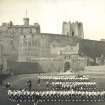
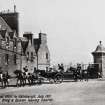
CASTLE ESPLANADE - Duke of York
ARCHITECT: Thomas Campbell 1839
REFERENCE: PUBLIC LIBRARY
Accession G. 72284 (circa 1880) - 1 print
Watching Brief (December 1998 - 24 January 1999)
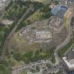
Throughout 1998, and into 1999, Kirkdale Archaeology maintained a watching brief during renovations within Edinburgh Castle's Hospital Square, in the NW of the castle. Hospital Square is formed by two rectangular ordnance stores, orientated EW, with a gap between them of some 27.5m, now cobbled over. The ordnance stores were both constructed in 1753, but in 1897 they were converted into hospitals, with the southern block retaining much of its' original character, while that to the N saw more drastic alterations, such as the addition of two towers projecting S from its' S face. Contemporary with these two structures was a powder magazine, built at the W end of the square, running N-S, between the two stores, but only physically connected to the S one. A protective blast wall ran N-S to the E of this magazine, connecting both the stores. In1897 this was demolished and levelled over to provide the present day square.
Excavations within Hospital Square have demonstrated the survival of substantial remains of the 1753 powder magazine. These would appear to be exclusively below floor foundations, and show the massive nature of the masonry required for a structure housing such dangerous materials. In no place were the bottom of these foundations revealed. While survival was generally good, many of the walls encountered had been damaged by service trenches cutting across the courtyard, although it seems likely that walls will survive elsewhere.
A remarkably homogenous soil deposit, which was also seen at the W end of the courtyard, seems likely to represent the infilling of a demolished structure to provide a level surface for the courtyard, presumably in 1897. While little was found connected with the use of the powder magazine, it was possible to confirm that the massive foundations of this structure survive substantially intact.
Sponsor : Historic Scotland
D Murray 1998
Kirkdale Archaeology
Watching Brief (6 January 1998 - 8 January 1998)
A watching brief was carried out by Kirkdale Archaeology on work being done by the British Geological Survey on the S side of Edinburgh Castle's Esplanade, between the 6th and the 8th of January 1998. This was in response to serious slumps developing on the slopes between the Esplanade and Johnstone Terrace below. The intention was to run a series of resitivity survey lines down and across the slope to determine soil depth, and dig test pits along these lines in an attempt to establish the cause of the failures, and to suggest appropriate remedial measures. Due to the extreme slope of the site, a professional climbing service provided specialist equipment and advice.
None of the test pits produced an identical sequence, but TP 3 and 4, at the top of the slope both produced two dumps of mortar rich rubble, probably representing different episodes of contemporary dumping. TP 1 produced two discrete dumps of rubble, separated by two layers of clay. TP 2 produced an entirely different sequence, and it is notable that this was the only trench at the base of the slope next to Johnstone Terrace. The finds appear to show that there has been work carried out here more recently than at the top of the slope, where the finds might agree with a mid eighteenth century date for the majority of the material present. Unfortunately, due to the inherently variable nature of these deposits it would be impossible to relate the trenches to each other without further excavation. It is also to be regretted that excavation did not relate any of the excavated dumps to the upstanding revetment walls, although their absence from the 1877 Ordnance Survey map makes it likely that all of these are relatively recent. Indeed the finds of white china from TP 2 may relate to the construction of these walls.
Excavation then showed evidence for a surprising depth of deposits across this slope. This material is almost all likely to represent eighteenth century or later landscaping, raising the possibility that medieval features may survive under this material, if use was made of this area in that period. Unfortunately it was not possible to relate any of the upstanding walls to any of the excavated areas, however it seems likely, on cartographic grounds, that these all post-date 1877.
Sponsor: Historic Scotland
Kirkdale Archaeology 1998
Watching Brief (19 November 1999 - 22 November 1999)
A watching brief was carried out on 22/10/99 on two holes dug for the siting of a new notice board in the NE corner of the castle esplanade, immediately to the E of the ticket caravan. Trench A, the westernmost, removed an anchor point for the Tattoo scaffolding.
It is very difficult to draw archaeological conclusions from small holes with no dating evidence. The main deposits seen; [101], [201] and [202] were thought most likely to be levelling material imported during large-scale changes to the esplanade. No date can be assigned to this activity from what was seen in these trenches.
There was a suspicion that trench 1 was reaching a solid surface, perhaps cobbled, and this could be tested in any future ground-works in this area. The slight differences within the trenches was thought to be caused when the anchor point was put in at trench A.
G Ewart 1999
Sponsor: Historic Scotland
Kirkdale Archaeology
Watching Brief (22 October 1999)
A watching brief was carried out on 22/10/99 on two holes dug for the siting of a new notice board in the NE corner of the castle esplanade, immediately to the E of the ticket caravan. Trench A, the westernmost, removed an anchor point for the Tattoo scaffolding.
It is very difficult to draw archaeological conclusions from small holes with no dating evidence. The main deposits seen; [101], [201] and [202] were thought most likely to be levelling material imported during large-scale changes to the esplanade. No date can be assigned to this activity from what was seen in these trenches.
There was a suspicion that trench 1 was reaching a solid surface, perhaps cobbled, and this could be tested in any future ground-works in this area. The slight differences within the trenches was thought to be caused when the anchor point was put in at trench A.
Sponsor: Historic Scotland
A Dunn 1999
Kirkdale Archaeology
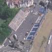
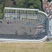
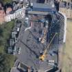
Watching Brief (February 2008)
NT 2531 7350 Monitoring of site investigation works was carried out in February 2008. The works included the excavation of seven test pits to examine the foundations of the Tattoo grandstands and 16 test pits at borehole locations, to investigate the depth and quality of the underlying bedrock. Deep deposits of made ground were encountered. Fragments of disarticulated human bone were also recovered from one test pit. In Princes Street Gardens made ground overlay either undated buried soils or concrete foundations for Raker supports for an earlier Esplanade Wall. Finds dating from the medieval period to the 20th century were recovered.
Archive: City of Edinburgh SMR and RCAHMS
Funder: Thomas and Adamson on behalf of the Edinburgh Military Tattoo Company
Ian Suddaby (CFA Archaeology Ltd), 2008
Excavation (December 2009 - September 2011)
NT 2530 7350 (centred on) A series of Scheduled Monument Consents (SMCs A–E) were granted, December 2009 – September 2011, for work associated with the design of new temporary stand for the Royal Edinburgh Military Tattoo.
SMC A: Existing utilities were realigned or replaced to accommodate new stand foundations. These works revealed part of the Spur, a triangular artillery fortification built in the 1540s and demolished in 1650. Part of a second boundary-type wall was revealed to the NE of the Spur and this overlay an infilled ditch. The corner of a building was revealed at the E end of the Esplanade. All of these remains may be shown on an Edinburgh plan drawn by Gordon of Rothiemay in 1647. At the top of Castle Wynd Steps, a massively built stone plinth may have been a part of the Esplanade wall which was demolished prior to 1780.
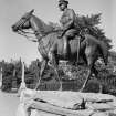
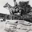
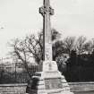
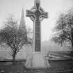
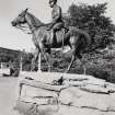
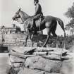
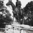
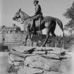
SMC B: The Scottish Horse Monument was dismantled and rebuilt on a new abutment projecting from the North Esplanade Wall. A photographic survey of the wall was carried out.
SMC C: This covered the erection of the new stands and had no archaeological significance.
SMC D: The statue of Earl Haig and its stone plinth were moved from the Esplanade to Hospital Square. Excavations in Hospital Square revealed the wall of the 1748–54 powder magazine and the blast wall to the E.
SMC E: Work to relocate utilities serving the castle took place in Princes Street Gardens, in the Moat Vault, in the Coal Yard and on the steep grass slope between the South Esplanade Wall and Johnston Terrace. Walls were recorded prior to the placement of pipes/ducts. No archaeological remains were recorded in Princes Street Gardens. In the Moat Vault, plinths associated with former arched vaults were recorded. In the Coal Yard, a buried wall was recorded. Between the South Esplanade Wall and Johnston Terrace, a stone revetment was recorded.
Additional non-SMC work took place in Castlehill, Ramsay Lane and Mound Place. In Ramsay Lane, the foundations of what may be tenement buildings were recorded and to the N, part of a culvert drain was recorded.
Archive: City of Edinburgh Council SMR and RCAHMS
Funder: Sir Robert McAlpine on behalf of Royal Edinburgh Military Tattoo Ltd
Information from Ian Suddaby (CFA Archaeology Ltd) 2012. OASIS ID: cfaarcha1-78685
Watching Brief (24 March 2016 - 4 May 2016)
NT 25376 73508 (NT27SE 1.33) A watching brief was undertaken, 24 March – 4 May 2016, during the excavation of the footprint for a replacement kiosk at the E end of the esplanade. The removal of whin setts revealed only modern infill and no features or finds of archaeological significance
were recorded.
Archive: NRHE (intended)
Funder: Historic Environment Scotland
Paul Fox – Kirkdale Archaeology
(Source: DES, Volume 17)
Watching Brief (28 February 2018 - 8 March 2018)
AOC Archaeology Group undertook a watching brief on behalf of Scottish Water in relation to excavations associated with an existing water main at Edinburgh Castle Esplanade (NGR: NT 25378 73520). The works lay at the north-eastern end of the Esplanade at the entrance to Castlehill. No significant archaeological remains or artefacts were revealed during the watching brief. The only remains encountered being a large, possibly carved, stone in the modern infill associated with the road surface preparation and services.
Information from Andrew McLean (AOC Archaeology Group) 8 March 2018.
OASIS ID: aocarcha1-311491
Watching Brief (15 May 2018)
A watching brief was carried out by CFA Archaeology Ltd at Edinburgh Castle. The works involved the removal of the existing tunnel control kiosk at the north-west end of the Esplanade and the erection of a new kiosk in the area immediately adjacent to the existing location. Relocation of the kiosk required the down-taking of a short stretch of low wall to the west, the installation of two concrete foundation lintels and a recess cut into the existing tarmac for a new low stone wall. The ground breaking works encountered no archaeological features or deposits.
Information from John Musgrove (CFA Archaeology Ltd) 1 July 2018.
OASIS ID: cfaarcha1-323072

