
Edinburgh Castle, St Mary's Church


Church (14th Century)
Site Name Edinburgh Castle, St Mary's Church
Classification Church (14th Century)
Alternative Name(s) Castle Church
Canmore ID 52085
Site Number NT27SE 1.24
NGR NT 25173 73460
Datum OSGB36 - NGR
Permalink http://canmore.org.uk/site/52085


- Council Edinburgh, City Of
- Parish Edinburgh (Edinburgh, City Of)
- Former Region Lothian
- Former District City Of Edinburgh
- Former County Midlothian
NT27SE 1.24 2517 7346.
Castle Church (NR) (Site of).
OS 25"map, (1953).
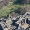
The Scottish National War Memorial stands in the position once occupied by St. Mary's Church a building which is on record as having been reconstructed in the 14th century and which appears to have been again remodelled in the 15th century. (RCAHMS 1951).
Visited by OS(JLD) 23 October 1953.
(NT 2517 7346) No additional remarks.
Visited by OS(JLD) 29 December 1953.
Publication Account (1951)
CROWN SQUARE.
On the S.W. side of the Half Moon Battery is an enclosure known as Crown Square or the Palace Yard. Next to St. Margaret's Chapel this is the highest part of the whole Castle. It is bounded on the N. by the Scottish National War Memorial, which stands in the position once occupied by St. Mary's Church, a building which is on record as having been reconstructed in the 14th century and which appears to have been again remodelled in the 15th century, if we may judge by some carved fragments preserved in an upper floor of the Portcullis Gate. On the W. is a block recently adapted as a Military museum; this dates from the mid-18th century, although one end of it rests on an earlier undercroft. The Great Hall, which determined the lay-out of the Square, stands on the S. and the Palace Block rises on the E. facing the town. The historic buildings are thus confined to the E. and S. sides, some part of the S.E. corner probably representing a certain "great chamber" built between 1433 and 1438 (50). The plan of the buildings that existed in 1754 is given in Fig. 93, and this may be compared with Fig. 94, which shows the present arrangement. In the latter plan, only the principal building-periods are indicated.
RCAHMS 1951
(50) Exch. Rolls, iv, p. 579

