
Edinburgh Castle, Foogs Gate


Gateway (17th Century)
Site Name Edinburgh Castle, Foogs Gate
Classification Gateway (17th Century)
Canmore ID 52082
Site Number NT27SE 1.21
NGR NT 25132 73474
Datum OSGB36 - NGR
Permalink http://canmore.org.uk/site/52082


- Council Edinburgh, City Of
- Parish Edinburgh (Edinburgh, City Of)
- Former Region Lothian
- Former District City Of Edinburgh
- Former County Midlothian
NT27SE 1.21 25132 73474.
Foogs Gate (NR).
OS 1/500 plan, (1895); OS 1/1250 plan.
Dates from 17th century. (RCAHMS 1951).
Visited by OS(JLD) 23 October 1953.
(NT 2513 7347) No additional remarks.
Visited by OS(JLD) 29 December 1953.
No further information
Visited by OS(SFS) 10 November 1975.
Publication Account (1951)
THE APPROACH.
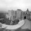
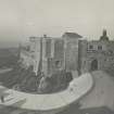
The approach to the Castle itself is by way of the Esplanade, across the head of which runs the Dry Ditch constructed some time between 1725 and 1742. The ditch is now traversed by a modern drawbridge, some scanty remains of an earlier bridge being seen on the left-hand side. The way of access then passes through an arched pend in the modern gatehouse, in the walls of which are inserted two interesting 17th-century panels sculptured with trophies of arms. On one of these the cannon known as Mons Meg can be identified. Inside and facing the back of the gate-house rises the Half-Moon Battery, constructed in 1574 and commanding the whole of the Old Town, which lies from one hundred to three hundred feet below. About 20 ft. below the parapet can be seen a gunloop, masked until recently by the wall of the battery; this was formed in the old curtain on the N. side of David's Tower at some time in the early 16th century, and is consequently the oldest gunloop in the Castle. The report of 1572 mentions six cannons int his part of the defences.
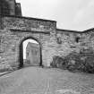
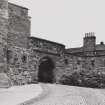
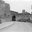
The access next skirts the N. base of the Battery up to the Inner Barrier, known as the “2d gate” in the 17th century, when it was protected by a drawbridge, and then runs up to the former position of the “Constable's Tower”, which is to-day occupied by the Portcullis Gate, or Morton's Gateway. The lower part of this latter building dates from 1574, and contains a vaulted transe adapted for two outer doors in two leaves, a portcullis, and an inner door, also in two leaves. The outer archway has an architectural framework of the period with superimposed double pilasters at each side. On a string course above, two seated lions rest as finials and flank an heraldic achievement. The heraldic panel, which exhibits the Royal Arms of Scotland below a crown, is modern, but the base and entablature are original. The frieze is enriched with hearts and mullets, charges which pertain to the Douglas coats of arms. The archway at the inner end of the transe is plain. A heavily barred window above lights a vaulted portcullis-room resting on the transe. On emerging from the gatehouse the road runs between the Argyle Battery on the right, where there was an inner gate, and the " long stairs" on the left, the latter a short cut to the summit of the Rock, partly rebuilt in 1785. It then winds round a shoulder and, entering through Foog's Gate (Fig.73), which dates from the 17th century, reaches the inner enclosure known as The Citadel, which it should be remembered had been the only fortified portion of the site down to the middle of the 16th century.
RCAHMS 1951
Watching Brief (29 January 2000 - 17 February 2000)
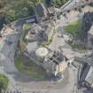
Archaeological monitoring was undertaken at Edinburgh Castle over various times during February 2000, while contractors carried out work excavating and exposing the line of a ten-inch water main. This pipe is situated below the cobbled road leading up to Foogs Gate and terminates in the base of large water tanks on the hill next to the road. The final section of the pipe track, measuring 7m in length, is cut into the scree slope below and to the W of the tanks.
While exposing this pipe the contractors came across two items of potential archaeological interest. Firstly, within the scree slope directly below the W side of water tank 1, a section of rough walling became visible. Secondly, within the cobbled road, overcutting of the pipe trench exposed a sequence of layers representing the development of the access road leading up to Foogs Gate. Both these items had been fully exposed and cleared prior to archaeological examination which has consequently eliminated the possibility of locating dateable finds.
In general terms the cutting of the water main trench must have seriously disturbed the sub-surface horizons making up the depth of road material. This disturbance however is very localised and it would be unlucky indeed if it has managed to destroy something of major importance. Examination of the two discrete areas 1 and 2 as well as a look at the rest of the opened pipe trench has not revealed obvious signs of early structures requiring conservation.
Sponsor: Historic Scotland
G Ewart 2000
Kirkdale Archaeology
Excavation (5 June 2013 - 25 November 2013)
NT 2512 7349 An integrated programme of test trenching, standing building recording and survey over exposed areas of bedrock was completed at intervals between 5 June and 25 November 2013.
The earliest features recorded were traces of eroded rock-cut features comprising slots and crudely-squared cuts thought to predate mid-16th-century masonry. The masonry and other remnants of defensive features were thought to range from the mid-16th century to the late 18th century, over which the first of the works to install water towers were carried out in the mid-19th century, with further work on new water towers in the early 1900s.
Archive: RCAHMS
Funder: Historic Scotland
Information from Alan Radley (Kirkdale Archaeology) 8 March 2014. OASIS ID: kirkdale1-279033

