
Edinburgh Castle


Settlement (Period Unassigned)
Site Name Edinburgh Castle
Classification Settlement (Period Unassigned)
Alternative Name(s) Castle Rock; Mills Mount
Canmore ID 74095
Site Number NT27SE 1.32
NGR NT 251 735
Datum OSGB36 - NGR
Permalink http://canmore.org.uk/site/74095


First 100 images shown. See the Collections panel (below) for a link to all digital images.
- Council Edinburgh, City Of
- Parish Edinburgh (Edinburgh, City Of)
- Former Region Lothian
- Former District City Of Edinburgh
- Former County Midlothian
NT27SE 1.32 251 735
See also NT27SE 1.17.
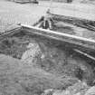
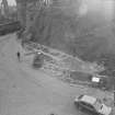
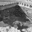
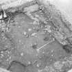
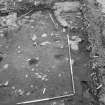
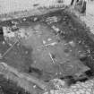
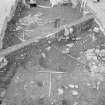
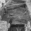
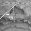
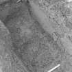
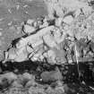
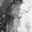
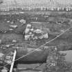
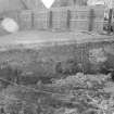
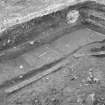
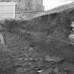
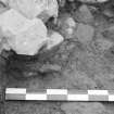
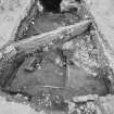
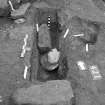
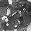
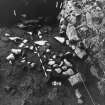
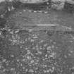
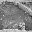
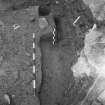
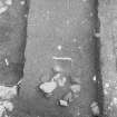
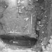
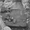
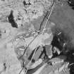
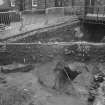
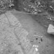
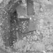
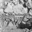
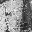
Area H. Mill's Mount. This area produced the earliest finds and occupation features (cobbled surfaces and hearths) dated to the early centuries AD, providing tentative evidence for the existence of native Iron Age and Dark Age forts. The principal finds were Roman and native pottery and a fibula brooch dated to the 1st-2nd centuries, sealed by layers which produced a comb dated 7th-10th centuries AD. This part of the rock, overlooked by the Citadel, was possibly enclosed by defences built on the edge of what had been a steep scarp.
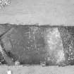
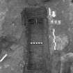
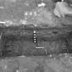
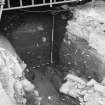
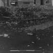
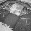
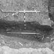
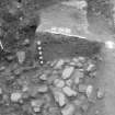
The next major event on this lower terrace was the construction of a stone causeway in the 12th-13th centuries. This road became choked with deposits of garden soil, indicating horticultural activity within the castle. During the 14th and 15th centuries large quantities of domestic rubbish were dumped, and this midden accumulated alongside a blacksmith's workshop, complete with furnace, quenching trough and recessed toolbox. The clay floor was strewn with smithing slag and ash. A system of stone lined drains was cut into the midden to carry water away from the workshop. After this building was demolished, it too was engulfed by midden. The construction of the smithy was dated by a very worn silver penny of Edward II.
As the castle expanded this area increased in importance and was extensively cobbled from the later 16th century onwards. Part of the Charles II defences (c1670) was found, truncated by the construction of a ramp built in the 1720s allowing access to the low defences.
Sponsor : SDD (HBM)
P Yeoman 1988a
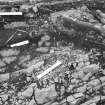
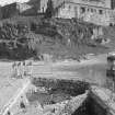
Area H Mills Mount, West Cut-and-Cover Tunnel Section
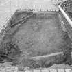
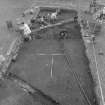
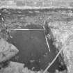
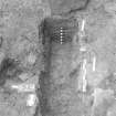
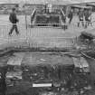
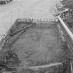
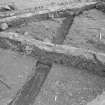
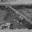
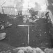
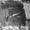
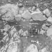
Extensions were added to the E, W and N of the 1988 excavations due to widening of the original tunnel specifications. The main aim of these extensions was to recover further evidence of the prehistoric levels revealed in 1988.
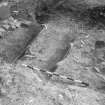
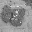
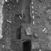
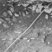
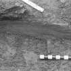
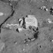
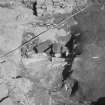
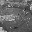
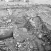
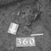
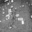
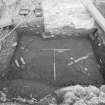
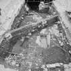
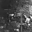
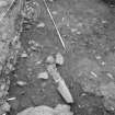
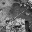
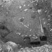
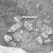
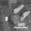
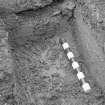
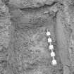
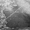
At the W end of this area the deposits were 4m in depth, the Roman Iron Age levels sealed 0.5m of anthropogenic deposits containing large quantities of animal bone and charcoal. A sample of the latter produced a radiocarbon date of c800 bc. One sherd of identifiable Bronze Age pottery and a saddle quern were also found. The structural evidence consisted of rough cobbled surfaces, which ran up to a post setting for what appeared to be the E side of a building, presumed to be an Iron Age round house. This building contained a beaten earth floor with a square stone box-hearth. There were finds of animal bones, metal objects and worked stone a whetstone and spindle whorl. Over 80 sherds of native and Roman pottery were found in the limited extended excavations. Numerous soil and environmental samples await analysis.
Sponsor : SDD (HBM)
P Yeoman 1989
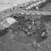
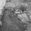
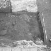
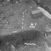
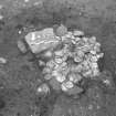
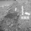
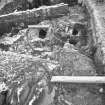
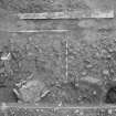
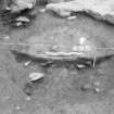
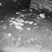
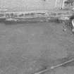
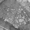
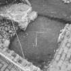
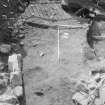
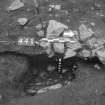
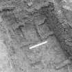
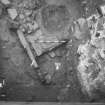
Excavation since 1987 has revealed archaeological deposits over 4m deep in places. Settlement on the NW shoulder of the hill can be seen to have begun in the early first millennium BC, a radiocarbon date of 972-830 cal BC having been obtained. Extensive remains of Iron Age houses are spread over the sloping bedrock surface in this area. Features including flagstone and cobble floors were covered by midden deposits including quantities of Roman and Iron Age pottery; two box-hearths spaced 10m apart probably indicate the presence of at least two buildings, presumably native roundhouses. Finds included worked bone, iron bores, and bronze jewellery; stone tools found included whetstones, querns and spindle whorls. One near-complete pot was found in smashed condition.
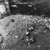
The density and location of the settlement suggests that the remains are part of a larger settlement spread across the rock. Although no traces of prehistoric ramparts are now visible or were excavated, it is possible that the excavated E entrance-area may have originated as part of the prehistoric defences. The dating of these structures is based upon both radiocarbon dates and upon the finds of Roman pottery and metalwork of the first and second centuries AD. One radiocarbon date from the cobbled floor of a house was of 174-337 cal AD. The Roman finds suggest that the native community had privileged access to Roman goods on a scale only locally paralleled at Traprain Law (NT57SE 1); over 100 sherds of course and fire pottery were found as well as glass fragments, several items of fine metalwork (including two fibulae) and a Hadrianic denarius. This Roman-period settlement grew out of the prehistoric community. The Roman period houses appear to have been built directly onto the prehistoric structures without any sign of a break.
S Driscoll 1991.
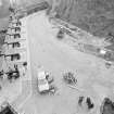
Excavation (1988 - 1989)
Excavation of settlement at Edinburgh Castle, area H, by Peter Yeoman, Historic Scotland 1988-89.
Note (6 November 2015 - 8 September 2016)
The appearance of Din Eidyn in the poem The Gododdin, and the documented siege of Din Etin about AD 638, have been interpreted as evidence of an early medieval fortress on the Castle Rock beneath Edinburgh Castle (summarised by Alcock 1981, 165-6), an identification to some extent confirmed by the discovery of early medieval midden deposits in excavations carried out 1988-91 (Driscoll and Yeoman 1997), albeit that no defences of this date have been uncovered. With such major construction works in the erection of the later castle defences, this is perhaps no more than can be expected, and, in view of its topographical setting, girt with cliffs and easily accessible only from the Esplanade on the E, there is every reason to include the Castle Rock in the Hillfort Atlas. The topography of the summit area, with the true summit forming a boss dominating the approach from the E along the edge of the NE cliffs, determines the maximum overall extent of the fort, roughly coincident with the castle and covering an area measuring some 230m from ESE to WNW by 140m (2.4ha). By the same token, the discovery in the excavations to the NW of the summit boss of middens apparently spanning the Roman Iron Age and early medieval period with no discernible hiatus, and beneath them elements of three round-houses and extensive paved surfaces, has been interpreted by the excavators as evidence of an earlier fort on the site. The chronology of these accumulated deposits, however, is not particularly clear, the contexts of the seven radiocarbon dates obtained, spanning from the 2nd century BC to the 7th century AD, possibly suggesting the deposits may have been much more mixed than the various analyses suggest. Numerous Roman items found in the middens, with up to 50 vessels represented, are overwhelmingly dated to the 1st or 2nd centuries, with only two sherds of fine wares that are probably later, and a sherd of glass probably of 4th century date. As such, the majority of the evidence here reflects patterns seen more widely across the Border Counties and Northumberland, where late Iron Age or Early Roman Iron Age settlements overlie the defences of earlier forts, albeit that no defences are known here. Even more tenuous would be the assertion that the summit was also enclosed in the Late Bronze Age on the grounds of the pits, hearths and cobbled surfaces found at the bottom of the sequence, though a very similar pattern of Late Bronze Age and late Iron Age / Roman Iron Age occupation has been established at the large hilltop enclosure on Traprain Law in East Lothian.
Information from An Atlas of Hillforts of Great Britain and Ireland – 08 September 2016. Atlas of Hillforts SC3713

