
Edinburgh, Craigiehall House, Icehouse


Icehouse (Period Unassigned)
Site Name Edinburgh, Craigiehall House, Icehouse
Classification Icehouse (Period Unassigned)
Alternative Name(s) Craigie Policies
Canmore ID 50425
Site Number NT17NE 43
NGR NT 17284 75620
Datum OSGB36 - NGR
Permalink http://canmore.org.uk/site/50425


- Council Edinburgh, City Of
- Parish Dalmeny
- Former Region Lothian
- Former District City Of Edinburgh
- Former County West Lothian
NT17NE 43 17284 75620
NT17NE 29.00 16671 75424 Craigiehall House (and related sites)
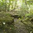
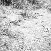
The remains of this icehouse are situated in dense undergrowth at the top of a steep bank about 14m S of the former main drive to Craigiehall House ( .00), 30m N of the row of houses in Riverside Road and 320m ENE of the present security gate to the 2nd Division Headquarters.
All that survives of the icehouse is the brick built circular upper section with an entrance on the NE side. It has a diameter of about 2m overall. The icehouse has been filled in for safety reasons.
The ice house is depicted on early editions of the OS 25-inch map, (Edinburghshire, sheet, various dates), as a small recatngular structure on the S side of the main drive.
Visited by RCAHMS (DE, EL), 18 September 2007

