
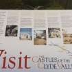
Cadzow Castle


Castle (Medieval)
Site Name Cadzow Castle
Classification Castle (Medieval)
Canmore ID 45740
Site Number NS75SW 8
NGR NS 73485 53755
Datum OSGB36 - NGR
Permalink http://canmore.org.uk/site/45740


First 100 images shown. See the Collections panel (below) for a link to all digital images.
- Council South Lanarkshire
- Parish Hamilton (South Lanarkshire)
- Former Region Strathclyde
- Former District Hamilton
- Former County Lanarkshire
NS75SW 8.00 73485 53755
NS75SW 8.01 73449 53768 Chapel
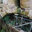
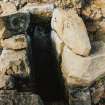
NS75SW 8.02 73482 53772 Well
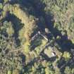
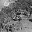
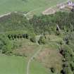
(Centred NS 7347 5376) Cadzow Castle (NR) (Ruins)
(NS 7344 5376) Chapel (NR) (Ruins)
(NS 7348 5377) Well (NR)
OS 6" map (1938)
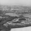
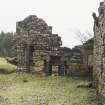
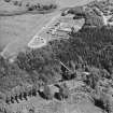
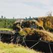
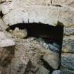
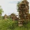
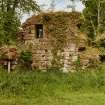
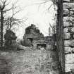
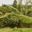
Cadzow Castle was the occasional residence of David I (1124-53), and his successors down to Robert the Bruce (1306-29) (Hamilton Civic Soc 1932). The oldest part of the ruins in the keep which was separated from later buildings by a moat. An arch now spans the moat. The remains of the Great Hall, Kitchen, and Chapel, can be seen.
J A Wilson 1937
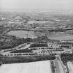
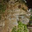
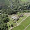
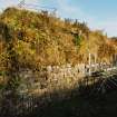
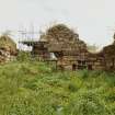
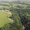
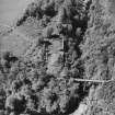
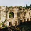
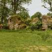
Cadzow Castle: A natural eminence towering over the Avon Water has been enclosed by strong walls and a wide ditch. At each end of the vulnerable face confronting the only approach, are two round towers projecting boldly into the ditch. One is much reduced; the other is almost complete. It has wide-mouthed gun-ports to enfilade the walls, and is sunk into the ditch as a gun battery or casemate. The castle was probably built by the second Earl of Arran c.1542-48.
S Cruden 1960
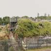
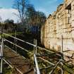
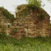
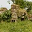
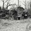
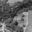
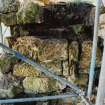
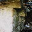
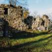
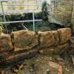
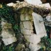
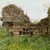
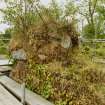
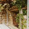
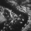
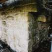
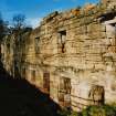
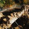
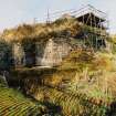
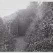
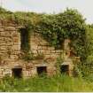
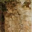
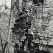
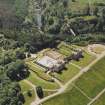
The ruins of Cadzow Castle comprise a strongly-constructed keep with drum towers at the SW and SE angles - the former standing up to 4.5m in height, and the latter - a slighter tower - up to 0.7m. The area between the north and south walls is occupied by a mound of rubble, beneath which a number of vaulted chambers and passages exist. The interior, on the east side of the central passageway, is inaccessible except for one vaulted chamber. The remains of later buildings forming three sides of a courtyard are situated on slightly higher ground to the west of the keep beyond the ditch which encloses it on the west and south sides. These walls are c.3.5m in height.
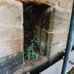
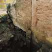
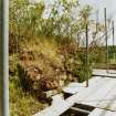
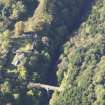
The Well is now partially filled in, but part of its structure still remains within the NW angle of the keep. A relatively modern bridge crosses the ditch from the roadway into the passageway on the south side. Here, the ditch is 6.0m deep. A projecting weathered sculpture of a human head was noted on a rock outcrop below the west wall of the keep, and may have served for the abutment of a bridge.
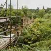
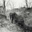
On the south side of the modern road is a short rocky escarpment on top of which, and running along its edge, are traces of the foundations of a strong wall (in places 3.2m thick) - probably an enceinte. On its south side is a broad ditch 11.0m wide and 1.7m maximum depth which runs NNW-SSE for an overall distance of 150 metres. It decreases in depth and width towards its western extremity. This probably indicates an outer bailey on this side of the castle.
Surveyed at 1/2500.
Visited by OS (JLD) 11 June 1959
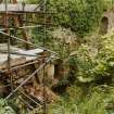
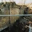
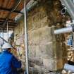
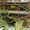
NS 7348 5375 The recording of the N elevation of the east range at Cadzow Castle was undertaken in the spring of 2000, while excavation and associated archaeological recording was completed in July 2000.
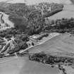
The castle sits on a natural eminence over the Avon water, and was the site of an occasional residence of David I and his successors, down to Robert the Bruce. The current stone castle was probably built by the second Earl of Arran between 1542-48, and was much modified in the later 18th and 19th centuries during landscaping works undertaken by the Duke of Hamilton.
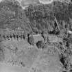
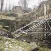
The archaeological recording and excavation was completed in advance of repair, restoration and drainage work made necessary by centuries of progressive collapse and dilapidation. The proximity of the structure to a steep-sided gorge has resulted in structural failing within the masonry, and this, coupled with insensitive alterations in preceding centuries, has accelerated the collapse of the structure.
Recording
The N elevation of the east range was drawn at a scale of 1:50, and features were recorded. Several separate phases of activity are represented by the surviving masonry, from the 16th-century construction to more recent landscaping, but the precise sequence of events remains conjectural.
In addition, a series of profiles of the N wall were prepared to provide an indication of the extent to which the structure is deflecting from the vertical.
Excavations
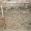
The initial excavated area lay immediately outside a doorway leading, via a flight of stone steps, down into the main vault beneath the east range. This area was excavated down to bedrock, with a further channel also excavated, leading S from the S limit of the main trench, to serve as a drain. Dating evidence was not forthcoming, but a relative sequence of construction was recorded. The implication was that more of the castle than had been previously realised may represent late (18th and 19th-century) romanticisation of an extant ruin.
The second phase of excavations concentrated on the N and W sides of the enclosure wall of the inner ward of the east range, with the emphasis on the NW corner of the wall which had recently suffered a partial collapse and which was to be consolidated. In addition, a record was made of the interior of a presumed stairwell at the NW corner of the structure.
The form of the present castle owes much to the 18th-century romanticisation of the ruins. The state of the masonry along the N and W walls of the enclosure, as revealed in these excavations, is the result of centuries of decay, alongside possibly deliberate slighting of the castle. Part of the decay is localised, such as the wallhead damage which is caused by trees, and part is more substantial, such as the crack along the wallheads separating the masonry skin from the wall core, which is a problem that clearly pre-dates the 18th-century landscaping. It is also noted that a deep vertical crack exists in the N end of the W wall. This could be the result of subsidence or military action.
Sponsor: Historic Scotland
D Murray 2000
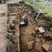
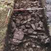
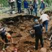
NS 7347 5376 An archaeological evaluation was undertaken in January and February 2001 at the site of Cadzow Castle. The evaluation comprised hand- and machine-excavation of approximately 183m2.
The evaluation identified a variety of structural features within the outer ward, which significantly alters the understanding of the layout of this part of the castle. The evaluation also revealed stratigraphic evidence of the development of the inner ward, allowing the differentiation of possibly original 16th-century elements of the castle from the later substantial rebuilding and 'romanticisation' of the monument in the 18th and 19th centuries.
Sponsor: Historic Scotland.
R Toolis 2001
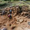
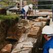
NS 7347 5376 As part of a three-year programme of excavation and survey, two areas of the inner ward of Cadzow Castle (NMRS NS75SW 8) were excavated in August and September 2001. The castle is thought to date from the second quarter of the 16th century, the work of Sir James Hamilton of Finnart, on behalf of the 2nd Earl of Arran. It resembles Finnart's other great work at Craignethan, and is presently interpreted as a similar early artillery fortification. The castle is thought to have been slighted after the siege of 1579 by forces on behalf of the Earl of Mar, Regent of James VI and his allies, against the Hamilton family. The castle featured as part of the formal landscape associated with Hamilton Palace, the work of William Adam in the earlier 18th century. It was subsequently altered during later works on the park by the 10th Duke of Hamilton in the early 19th century.
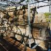
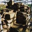
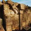
Area 1 was centred on the SE tower, part of the inner ward defences, associated with the curtain wall and a further tower at the SW corner of the inner ward defensive circuit. A large area was opened over and around the site of the SE tower and showed that post-demolition restoration works on both the fabric of the tower and revealed parts of the rampart/curtain dated to the landscaping of the site, probably during the early years of the 19th century. The tower showed signs of having been modified during its active life in that there was evidence that doorways, and possibly an outer ditch, were infilled prior to its demise in the late 16th century. Large numbers of glazed floor tiles were retrieved from the area around the demolished tower - a significant percentage of which were decorated with a 'J&M' design. The 'J&M' in question may refer to James V and his marriage to Mary of Guise (1538), although an identical single example found at Linlithgow Palace was ascribed to the marriage of James IV and Margaret (1503). The tower stood to at least three storeys, leading to a wall head circuit - this is indicated by fragments of masonry provisionally defining the N limits of the tower at its upper level.
The summit of the mounded interior of the inner ward (Area 2) was also excavated with several trenches, all of which revealed how traumatic the demolition of the inner elements of this part of the castle must have been. Considerable blocks of masonry still in bond were found upside down, suggesting the use of explosives.
A combination of excavation evidence and survey data suggests that the inner ward had a central tower-like structure of apparently two storeys, the uppermost of which was some sort of hall with a vaulted roof. Access to this upper floor was from the N via some form of stair tower linked with a N range and courtyard complex immediately opposite the apparent bridging/crossing point from the outer ward.
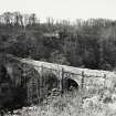
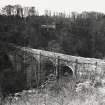
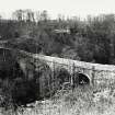
In general conclusion it is clear that 19th-century landscaping considerably changed the aspect and setting of the site as it presently stands. This is most graphically reflected by the infilling of the rock-cut ditch (to the S of the inner ward), to accommodate a new access road linked to the present Duke's Bridge (1863).
Sponsor: Historic Scotland
G Ewart, D Murray and D Stewart 2001
The excavation archive from the AOC Archaeology Group 2001 archaeological evaluation of Cadzow Castle has been catalogued. The archive consists of manuscripts, photographic material and drawings.
Historic Scotland Archive Project (SW) 2002
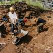
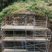
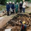
NS 728 542 The second season of archaeological excavation was completed on elements of the Inner Ward of the late 15th-/early 16th-century Cadzow Castle. Following on from the 2001 programme of trial trenching on and around the Inner Ward (DES 2001, 92-3), a more extensive programme of excavation was completed in the summer of 2002. The project was also timed to exploit maximum potential numbers of visitors to the site, including school parties, specialist groups and the general public. The fieldwork was further complemented by the creation of a website for the project (www.cadzowcastle.net) and displays in the local museums.
Work continued within the inner ditch and the principal structures of the central tower. Although extensive 18th- and 19th-century stone robbing and landscaping has significantly obscured the layout of the Inner Ward, the excavation suggests that a central complex of chambers survives to first-floor level, within a curtain wall, accessed from the N and W.
The 2002 excavation continued the investigation of the Inner Ward in two general areas: further work in Area 1 - the summit of the rubble mound (Trenches 3, 7 and 8); and the W section of the inner ditch, next to the SW Tower (Trench 9, Area 3).
In both areas the principal aim was to define the extent of late landscaping and consequent survival of earlier structures and deposits. The work was delimited by several logistical and safety issues, but also by the need to preserve structures associated with the 18th- and 19th-century landscaping phases.
In addition, recording work was completed on a section of masonry revealed during shrub and undergrowth clearance work on the S side of the inner ditch (Area 4).
The 2002 programme clearly showed that the site had been massively reduced on its S and E sides particularly. The rubble was apparently simply for the infill of the inner ditch and related landscaping, most likely between 1813-20 on behalf of the 10th Duke of Hamilton - 'Il Magnifico'. Any remaining walls to the N and W were found then to have been pulled down over the general interior of the tower. The resulting mound was then crudely revetted and its edges battered to create a stable viewing platform overlooking the Avon Gorge within the (by then) densely planted 19th-century park.
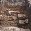
The surviving structures within the Inner Ward Tower were limited to the lower principal floor where evidence of a series of vaulted chambers was found below the 19th-century rubble and collapse. The walls have not yet been fully exposed but some featured fine blue plaster rendering with doors and windows still in situ. Some evidence of the upper floor arrangements survived in the form of a possible main stair and doorway towards the W side of the tower, a newel stair on the N, and a garderobe on the E. All these features are thought to have served more formal apartments, the quality of which is suggested by the massive assemblage of floor tiles and fragments of moulded masonry discarded during the 19th-century works.
The work within the inner ditch showed it had been largely backfilled with rubble, creating the present graded profile upon which the present S access road was constructed.
Archive to be deposited in the NMRS.
Sponsor: HS
G Ewart, D Stewart, D Murray and A Hollinrake 2002
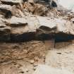
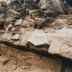
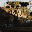
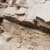
NS 734 537 The third and final season of excavation in June and July 2003 concentrated on the Inner Ward and outer defensive ditches of this 16th-century castle. Excavation in the ditches showed that an earlier layout of ditches to the S and W of the stone castle was changed during the later 16th century. The new arrangement comprised an enlarged and extended S ditch extending well beyond the limits of the castle, and the recycling of the earlier W ditch as a drain for the new S cutting. Although much damaged by later plantation, it seems likely that the later ditch arrangement was revetted in stone on its inside face and was complemented by a low earthwork bank, also crudely faced in stone.
A large area was cleared of rubble in the NE corner of the Inner Ward revealing a two-phased building programme. The earlier arrangement appears to have comprised a roughly L-shaped plan for the principal structures within the outer defensive E wall presently defining the Inner Ward. To the W of the excavated area was the larger element - a building on three floors with a hall at the top. This was complemented by a narrow range also with three levels (ground, first, second), presently described as a gallery. The earliest layout so far discovered suggests that the area to the N of the gallery and E of the hall block was an open courtyard, and there was a further narrow range extending up to the curtain wall running alongside and parallel with the E curtain wall.
The later building work saw the infill of this earlier courtyard by the construction of at least five separate chambers on two floors. This later work was characterised by rather crude masonry and saw the introduction of a (possible) kitchen at ground level in the new layout. The latter was suggested by a large oven or hearth. The results of the work overall clearly show how the early 16th-century castle was adapted during the later 16th century to perhaps accommodate more people within a more substantial artillery work protecting its southern side.
A coin found in demolition debris associated with the destruction of the NE block post-dates 1575. This is in contrast with two other coins, one of which is probably a jetton (as yet undated) and the other a penny, which although not formally identified, appears likely to be of 15th-century date. The latter pair were found near the displaced flagged floor, thought to underlie the inserted vault, in association with some pins and other fastenings - possibly the remains of a now-rotted garment. Until specialists have formally dated the coins from the 2003 season, speculation on their importance for dating the building and collapse of the NE block must remain provisional. However, the later coin does imply the destruction of the range towards the end of the 16th century, very much in line with assumptions of damage in the attacks of 1579. Several elegantly carved and some inscribed masonry fragments were also found.
Archive to be deposited in the NMRS.
Sponsor: HS
G Ewart 2003
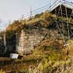
NS 728 542 A short period of archaeological monitoring was undertaken in October and November 2003 as part of an ongoing consolidation programme on the castle masonry.
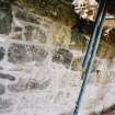
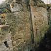
The first phase monitored the removal of turf and topsoil from a small section of wall head at the far NW corner of the Middle Ward. This limited clearance work helped to expose the tops of the outer face masonry of the N and W walls, as well as better define the broken window set in the N wall. Recording was also undertaken of the outer faces of the N and W walls. It appears that the two walls were constructed in a single phase.
Archive to be deposited in the NMRS.
Sponsor: HS.
C Shaw 2004
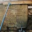
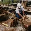
Carved stones NS 728 542 The stone fragments were recovered during three seasons of investigation and excavation between 2001-3. Until now, the stone collection has been laid out in various areas within the castle, with little or no protection from environmental damage. However, plans are now underway to build a permanent stone store on the site, beside the W wall.
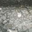
Most of the present castle, a stronghold of the Hamilton family, dates from the late 15th/16th century, and underwent a series of alterations during this period. Many of the fragments show only rather basic worked surfaces, but about a third of the stones exhibit details that allow not only a function to be revealed, but also permit comparisons with nearby Craignethan Castle, another Hamilton building. A number of corbels were found, and these are of two types. One type is simply worked with a large quarter-roll and a fillet articulating its upper edge. The second type is more complex, with two to three roll mouldings separated by fillets. Both types of corbel can also be found at Craignethan. Another carved stone with Craignethan links is a single piece of a drainage spout (now broken into two), which has a band of rope ornament around the edge of the spout. This type of ornament is found in great abundance at Craignethan, where it is also used to decorate stone water spouts. At least two stones in the Cadzow collection indicate the presence of oriel windows, and a number of large voussoirs were probably originally coated in painted plaster. Fragments of painted plaster were recovered during the excavation, and a few architectural carved stones with traces of painted plaster still adhering were also found. The careful use of keyed surfaces on the voussoirs, minimising the visible jointing, would have provided a sound and even surface for similar painted decoration.
Inventory: still continuing; 140 pieces; mostly 16th century; NS75SW 8.00.
Archive held by HS and NMRS. See also www.arch-etype.net.
Sponsor: HS.
M Markus 2005
NS 7344 5376 Archaeological monitoring and recording were undertaken at Cadzow Castle in November 2005 during the clearance of a small area for a concrete base, in advance of the installation of a new store for architectural fragments. The works were located W of the W limits of the site and S of the tower-like structure defining the NW corner of the castle enclosure. This work demonstrated that archaeologically sensitive surfaces are very close to the present ground level on the W side of the castle. These in turn suggest that there is no significant accumulation of 'occupation' debris.
It was thought possible that the line of a shallow ditch picked up further S might have extended as far as this trench. However, no trace was found. In all probability the ditch lies slightly further W, if it extends further N at all. It is possible that the ditch is not a defensive feature but is part of the pale surrounding the 15th-century deer park, and may not extend anywhere near the castle. The characteristics of this ditch - shallow, with a revetted wall on its inner (E) side - suggest a more 'park-like' function than serious defence against attack.
Archive to be deposited in NMRS.
Sponsor: Historic Scotland.
Gordon Ewart, 2006.
NS 734 537 Archaeological monitoring and recording were undertaken at Cadzow Castle in May 2006 during the removal (for reinstatement) of two large sandstone blocks, the first forming the sill of a window and the other acting as both sill support and the NW margin of an aperture floored by a projecting spout. The work took place at the NW corner of the Outer Ward at the level of the top of the basement barrel vault. Drawings were made and photographs taken in advance of any intrusive works to record the positioning of the various elements. Further recording was undertaken after clearance and removal of fallen masonry.
Archive to be deposited in NMRS.
Sponsor: Historic Scotland.
Paul Fox, 2006.
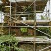
NS 7344 5377 Further excavation and recording was undertaken in the NW corner of the Middle Ward of Cadzow Castle. This was the latest in a series of visits examining features in this area. This latest work was a brief examination of areas already partially excavated, now more readily accessible due the removal of scaffolding.
Information from OASIS ID: kirkdale1-60238
Excavation (8 June 2000 - 14 July 2000)
NS 7348 5375 The castle sits on a natural eminence over the Avon water, and was the site of an occasional residence of David I and his successors, down to Robert the Bruce. The current stone castle was probably built by the second Earl of Arran between 1542–48, and was much modified in the later 18th and 19th centuries during landscaping works undertaken by the Duke of Hamilton.
The archaeological recording and excavation was completed in advance of repair, restoration and drainage work made necessary by centuries of progressive collapse and dilapidation.The proximity of the structure to a steep-sided gorge has resulted in structural failing within the masonry, and this, coupled within sensitive alterations in preceding centuries, has accelerated the collapse of the structure.
Recording
The N elevation of the east range was drawn at a scale of 1:50,and features were recorded. Several separate phases of activity are represented by the surviving masonry, from the 16th-century construction to more recent landscaping, but the precise sequence of events remains conjectural.In addition, a series of profiles of the N wall were prepared to provide an indication of the extent to which the structure is deflecting from the vertical.
Excavations
The initial excavated area lay immediately outside a doorway leading, via a flight of stone steps, down into the main vault beneath the east range. This area was excavated down to bedrock,with a further channel also excavated, leading S from the S limit of the main trench, to serve as a drain. Dating evidence was not forthcoming, but a relative sequence of construction was recorded. The implication was that more of the castle than had been previously realised may represent late (18th and 19th-century) romanticisation of an extant ruin.
The second phase of excavations concentrated on the N and W sides of the enclosure wall of the inner ward of the east range,with the emphasis on the NW corner of the wall which had recently suffered a partial collapse and which was to be consolidated. In addition, a record was made of the interior of a presumed stair well at the NW corner of the structure.
The form of the present castle owes much to the 18th-centuryromanticisation of the ruins. The state of the masonry along the N and W walls of the enclosure, as revealed in these excavations, is the result of centuries of decay, alongside possibly deliberate slighting of the castle. Part of the decay is localised, such as the wallhead damage which is caused by trees, and part is more substantial, such as the crack along the wall heads separating the masonry skin from the wall core, which is a problem that clearly pre-dates the 18th-century landscaping. It is also noted that a deep vertical crack exists in the N end of the W wall. This could be the result of subsidence or military action.
D Murray 2000
Sponsor: Historic Scotland
Kirkdale Archaeology
Standing Building Recording (16 March 2000 - 22 March 2000)
NS 7348 5375 The recording of the N elevation of the east range at Cadzow Castle was undertaken in the spring of 2000,while excavation and associated archaeological recording was completed in July 2000.
D Murray 2000
Sponsor: Historic Scotland
Kirkdale Archaeology
Excavation (29 August 2001 - 6 October 2001)
NS 7347 5376 As part of a three-year programme of excavation and survey, two areas of the inner ward of Cadzow Castle (NMRS NS 75 SW 8) were excavated in August and September 2001.The castle is thought to date from the second quarter of the 16thcentury, the work of Sir James Hamilton of Finnart, on behalf of the 2nd Earl of Arran. It resembles Finnart’s other great work at Craignethan, and is presently interpreted as a similar early artillery fortification. The castle is thought to have been slighted after the siege of 1579 by forces on behalf of the Earl of Mar, Regent of James VI and his allies, against the Hamilton family. The castle featured as part of the formal landscape associated with Hamilton Palace, the work of William Adam in the earlier 18th century. It was subsequently altered during later works on the park by the10th Duke of Hamilton in the early 19th century.
Area 1 was centred on the SE tower, part of the inner ward defences, associated with the curtain wall and a further tower at the SW corner of the inner ward defensive circuit. A large area was opened over and around the site of the SE tower and showed that post-demolition restoration works on both the fabric of the tower and revealed parts of the rampart/curtain dated to the landscaping of the site, probably during the early years of the19th century. The tower showed signs of having been modified during its active life in that there was evidence that doorways,and possibly an outer ditch, were infilled prior to its demise in the late 16th century. Large numbers of glazed floor tiles were retrieved from the area around the demolished tower – a significant percentage of which were decorated with a ‘J&M’ design. The ‘J&M’ in question may refer to James V and his marriage to Mary of Guise (1538), although an identical single example found at Linlithgow Palace was ascribed to the marriage of James IV and Margaret (1503). The tower stood to at least three storeys, leading to a wall head circuit – this is indicated by fragments of masonry provisionally defining the N limits of the tower at its upper level.
The summit of the mounded interior of the inner ward (Area 2)was also excavated with several trenches, all of which revealed how traumatic the demolition of the inner elements of this part of the castle must have been. Considerable blocks of masonry still in bond were found upside down, suggesting the use of explosives.
A combination of excavation evidence and survey data suggests that the inner ward had a central tower-like structure of apparently two storeys, the uppermost of which was some sort of hall with a vaulted roof. Access to this upper floor was from the N via some form of stair tower linked with a N range and courtyard complex immediately opposite the apparent bridging/crossing point from the outer ward.
In general conclusion it is clear that 19th-century landscaping considerably changed the aspect and setting of the site as it presently stands. This is most graphically reflected by the infilling of the rock-cut ditch (to the S of the inner ward), to accommodate a new access road linked to the present Duke’s Bridge (1863).
G Ewart, D Murray, D Stewart 2001
Sponsor: Historic Scotland
Kirkdale Archaeology
Excavation (10 June 2002 - 14 July 2002)
NS 728 542 The second season of archaeological excavation was completed on elements of the Inner Ward of the late 15th-/early 16th-century Cadzow Castle (NS 75 SW 8). Following on from the 2001 programme of trial trenching on and around the Inner Ward (DES 2001, 92–3), a more extensive programme of excavation was completed in the summer of 2002. The project was also timed to exploit maximum potential numbers of visitors to the site, including school parties, specialist groups and the general public. The fieldwork was further complemented by the creation of a website for the project (www.cadzowcastle.net) and displays in the local museums.
Work continued within the inner ditch and the principal structures of the central tower. Although extensive 18th- and 19th-century stone robbing and landscaping has significantly obscured the layout of the Inner Ward, the excavation suggests that a central complex of chambers survives to first-floor level, within a curtain wall, accessed from the N and W.
The 2002 excavation continued the investigation of the Inner Ward in two general areas: further work in Area 1 – the summit of the rubble mound (Trenches 3, 7 and 8); and the W section of the inner ditch, next to the SW Tower (Trench 9, Area 3).In both areas the principal aim was to define the extent of late landscaping and consequent survival of earlier structures and deposits. The work was delimited by several logistical and safety issues, but also by the need to preserve structures associated with the 18th- and 19th-century landscaping phases.
In addition, recording work was completed on a section of masonry revealed during shrub and undergrowth clearance work on the S side of the inner ditch (Area 4).
The 2002 programme clearly showed that the site had been massively reduced on its S and E sides particularly. The rubble was apparently simply for the infill of the inner ditch and related landscaping, most likely between 1813–20 on behalf of the 10thDuke of Hamilton – ‘Il Magnifico’. Any remaining walls to the N and W were found then to have been pulled down over the general interior of the tower. The resulting mound was then crudely revetted and its edges battered to create a stable viewing platform overlooking the Avon Gorge within the (by then) densely planted19th-century park.
The surviving structures within the Inner Ward Tower were limited to the lower principal floor where evidence of a series of vaulted chambers was found below the 19th-century rubble and collapse. The walls have not yet been fully exposed but some featured fine blue plaster rendering with doors and windows still in situ. Some evidence of the upper floor arrangements survived in the form of a possible main stair and doorway towards the W side of the tower, a newel stair on the N, and a garderobe on the E. All these features are thought to have served more formal apartments, the quality of which is suggested by the massive assemblage of floor tiles and fragments of moulded masonry discarded during the 19th-century works.The work within the inner ditch showed it had been largely backfilled with rubble, creating the present graded profile upon which the present S access road was constructed.
G Ewart, D Stewart, D Murray, & A Hollinrake 2002
Sponsor: Historic Scotland
Kirkdale Archaeology
Excavation (28 May 2003 - 2 July 2003)
NS 734 537 The third and final season of excavation in June and July 2003 concentrated on the Inner Ward and outer defensive ditches of this 16th-century castle. Excavation in the ditches showed that an earlier layout of ditches to the S and W of the stone castle was changed during the later 16th century. The new arrangement comprised an enlarged and extended S ditch extending well beyond the limits of the castle, and the recycling of the earlier W ditch as a drain for the new S cutting. Although much damaged by later plantation, it seems likely that the later ditch arrangement was revetted in stone on its inside face and was complemented by a low earthwork bank, also crudely faced in stone.
A large area was cleared of rubble in the NE corner of the Inner Ward revealing a two-phased building programme. The earlier arrangement appears to have comprised a roughly L-shaped plan for the principal structures within the outer defensive E wall presently defining the Inner Ward. To the W of the excavated area was the larger element - a building on three floors with a hall at the top. This was complemented by a narrow range also with three levels (ground, first, second), presently described as a gallery. The earliest layout so far discovered suggests that the area to the N of the gallery and E of the hall block was an open courtyard, and there was a further narrow range extending up to the curtain wall running alongside and parallel with the E curtain wall.
The later building work saw the infill of this earlier courtyard by the construction of at least five separate chambers on two floors. This later work was characterised by rather crude masonry and saw the introduction of a (possible) kitchen at ground level in the new layout. The latter was suggested by a large oven or hearth. The results of the work overall clearly show how the early 16th-century castle was adapted during the later 16th century to perhaps accommodate more people within a more substantial artillery work protecting its southern side.
A coin found in demolition debris associated with the destruction of the NE block post-dates 1575. This is in contrast with two other coins, one of which is probably a jetton (as yet undated) and the other a penny, which although not formally identified, appears likely to be of 15th-century date. The latter pair were found near the displaced flagged floor, thought to underlie the inserted vault, in association with some pins and other fastenings - possibly the remains of a now-rotted garment. Until specialists have formally dated the coins from the 2003 season, speculation on their importance for dating the building and collapse of the NE block must remain provisional. However, the later coin does imply the destruction of the range towards the end of the 16th century, very much in line with assumptions of damage in the attacks of 1579. Several elegantly carved and some inscribed masonry fragments were also found.
G Ewart 2003
Sponsor: Historic Scotland
Kirkdale Archaeology
Watching Brief (27 October 2003 - 21 November 2003)
NS 728 542 A short period of archaeological monitoring was undertaken in October and November 2003 as part of an on going consolidation programme on the castle masonry.The first phase monitored the removal of turf and topsoil from a small section of wall head at the far NW corner of the Middle Ward. This limited clearance work helped to expose the tops of the outer face masonry of the N and W walls, as well as better define the broken window set in the N wall. Recording was also undertaken of the outer faces of the N and W walls. It appears that the two walls were constructed in a single phase.
G Ewart 2004
Sponsor: Historic Scotland
Kirkdale Archaeology
Watching Brief (November 2005)
NS 7344 5376 Archaeological monitoring and recording were undertaken at Cadzow Castle in November 2005 during the clearance of a small area for a concrete base, in advance of the installation of a new store for architectural fragments. The works were located W of the W limits of the site and S of the tower-like structure defining the NW corner of the castle enclosure. This work demonstrated that archaeologically sensitive surfaces are very close to the present ground level on the W side of the castle. These in turn suggest that there is no significant accumulation of 'occupation' debris.
It was thought possible that the line of a shallow ditch picked up further S might have extended as far as this trench. However, no trace was found. In all probability the ditch lies slightly further W, if it extends further N at all. It is possible that the ditch is not a defensive feature but is part of the pale surrounding the 15th-century deer park, and may not extend anywhere near the castle. The characteristics of this ditch - shallow, with a revetted wall on its inner (E) side - suggest a more 'park-like' function than serious defence against attack.
Archive to be deposited in NMRS.
Sponsor: Historic Scotland.
G Ewart 2006
Watching Brief (May 2006)
NS 734 537 Archaeological monitoring and recording were undertaken at Cadzow Castle in May 2006 during the removal (for reinstatement) of two large sandstone blocks, the first forming the sill of a window and the other acting as both sill support and the NW margin of an aperture floored by a projecting spout. The work took place at the NW corner of the Outer Ward at the level of the top of the basement barrel vault. Drawings were made and photographs taken in advance of any intrusive works to record the positioning of the various elements. Further recording was undertaken after clearance and removal of fallen masonry.
Archive to be deposited in NMRS.
Sponsor: Historic Scotland.
P Fox 2006
Excavation (16 October 2006 - 11 October 2007)
NS 734 537 A series of three separate programmes of excavation and standing building recording were completed on two areas of the castle between 16 October 2006 and the 11 October 2007. The first area concentrated on walls defining the S side of the probable courtyard within the Inner Ward. Evidence was found of the modification of primary build (early 16th century) with the addition of later masonry thought at present
to relate to the later 16th-century reinforcement of the site under the Second Earl of Arran. Evidence was also found of the 18th and 19th-century stabilisation and landscaping programme when the castle was absorbed into the park around Hamilton Palace.
The other focus for excavation was the tower at the NW corner of the Outer Ward. The need to stabilise the vaulted undercroft of this structure brought to light further evidence of the conversion and subdivision of the early 16th-century structure during the later 16th century. This took the form of the addition of a new cross
wall at first floor level and the possible creation of a new access passage along the S side of the tower, also at first floor level. This exercise may also be associated with the blocking of two apertures looking E and S respectively. The tower appears to have been destroyed by fire on the evidence of extensive burning and scorching of walls at first floor level, an event dating to the late medieval period on the evidence of pottery.
Archive to be deposited with RCAHMS.
Funder: Historic Scotland.
OASIS ID: kirkdale1-249651
Watching Brief (23 May 2011 - 24 May 2011)
Paul Fox – Kirkdale Archaeology
NS 7348 5376 and NS 7350 5373 A watching brief was maintained on 23 May 2011 during masonry restoration at Cadzow Castle. The first phase of work consisted of the removal and reinstatement of a badly leaning wall in the Inner Ward of the castle (NS 7348 5376). The second phase involved the clearance of earth from an unidentified structure located on the bedrock ridge to the SE of the castle (NS 7350 5373). The newly uncovered masonry was then cleaned and reinstated. No archaeological deposits or finds were recorded; however, the exposed masonry was examined and recorded.
Archive: RCAHMS (intended)
Funder: Historic Scotland
Kirkdale Archaeology, 2011
Information also reported in Oasis (kirkdale1-123778) 20 November 2012

