
Muirkirk, Glasgow And South Western Railway


Railway (19th Century)
Site Name Muirkirk, Glasgow And South Western Railway
Classification Railway (19th Century)
Canmore ID 76357
Site Number NS62NE 32
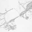
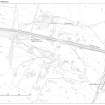
NGR NS 6500 2560
NGR Description From NS 6500 2560 to NS 6958 2654
Datum OSGB36 - NGR
Permalink http://canmore.org.uk/site/76357


- Council East Ayrshire
- Parish Muirkirk
- Former Region Strathclyde
- Former District Cumnock And Doon Valley
- Former County Ayrshire
Field Visit (February 1991 - November 1991)
NS62NE 32.00 6500 2560
For successive stations at Muirkirk (NS c. 692 263 and NS 6951 2651), see NS62NE 44 and 45, respectively.
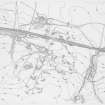
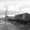
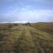
The remains of the railways that carried the minerals and finished goods to and from the Ironworks at Muirkirk (NS62NE 17) can still be followed across the surrounding moorland. Although the tracks have been removed, the remains of the cuttings, embankments and viaducts form a series of major features. The first line to be built was the Muirkirk branch of the Glasgow and South Western Railway, which opened in the late 1840s. This line connected with the port of Ayr and allowed materials to be exported more efficiently. Later, in the 1870s a branch from the Caledonian Line was opened, providing a cross-country route from Muirkirk to Lanark (NS72NW 6).
Between 1856 and 1895, the respective dates of survey of the first and 2nd ed OS 25-inch maps, the Glasgow and South Western Railway branch line was reconstructed and converted in width from single track to double track (Ayrshire, Sheets xxx.8, 11-12; xxxi.5, 1856 {survey date} and 1896). Evidence of the reconstruction can be seen in an eroding section of the railway embankment, 220m to the SW of Upper Wellwood (NS62NE 34), where the indentations left by the sleepers of the earlier track are visible some 1.3m below the surface; the sleepers appear to have been removed. During this reconstruction, all the culverts and bridges were entirely rebuilt.
Several spurs from the earlier railway linked into the mineral extraction fields. At Nether Wellwood (NS62NE 18.00), a curving spur ran to a coal and ironstone mine on the N side of the railway; the mine had fallen out of use before the railway was reconstructed and the junction between the spur and the railway is buried beneath the later embankment (NS 6636 2540). To the E, in the area of Upper Wellwood, another spur linked the railway with an inclined plane which carried coal down from the mines to the S (NS 6845 2575). Further E still in the area to the S of the site of the Ironworks (NS62NE 17), a spur was extended S from the terminal of the railway to serve two limekilns (NS 7030 2658). After the closure of the Ironworks, the railway continued in use, but passenger services were eventually withdrawn in 1951.
Visited by RCAHMS (ARW, SPH) February-November 1991.
J Thomas 1981.

