
Barnweill Church


Cemetery (Medieval) - (Post Medieval), Church (Medieval)
Site Name Barnweill Church
Classification Cemetery (Medieval) - (Post Medieval), Church (Medieval)
Canmore ID 42709
Site Number NS42NW 1
NGR NS 40506 29903
Datum OSGB36 - NGR
Permalink http://canmore.org.uk/site/42709


- Council South Ayrshire
- Parish Craigie
- Former Region Strathclyde
- Former District Kyle And Carrick
- Former County Ayrshire
NS42NW 1 40506 29903
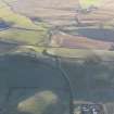
(NS 4050 2990) Barnweill Church (NR) (remains of)
OS 6" map (1967)
The pre-Reformation church of the parish of Barnweill is said to have been built about the beginning of the 15th century (Name Book 1857). It belonged to the monastery at Fail. The parish was suppressed in 1673 when the church which was dedicated to the Holy Rood (H Scott 1950) was allowed to fall into ruins. In 1857, its ivy-covered gables stood to their original height, but the side walls were almost level with the ground. The bell from this church was given to the Scottish Episcopalian Chapel at Ayr in 1857. Paterson notes a font in the west gable, and that the oldest legible tombstone in the churchyard is dated 1661, though there were several others evidently much older.
G Chalmers 1820; J Paterson 1863; H Scott 1920
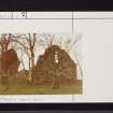
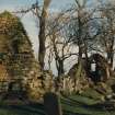
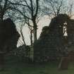
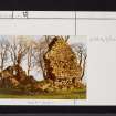
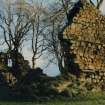
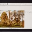
This is a small rectangular building, the walls of which are in a crumbling condition. The North and south walls are extremely low, though the gables still stand to their original height. There is an entrance in both the north and south walls, in the east gable is a segmental arched window which may support the 15th century date given in the Ordnance Survey Name Book (ONB). The 'font' mentioned by Paterson appears to be an aumbry or sacrament house. The tombstone dated 1661 was not identified but no doubt it is one of the dozen or so old stones which remain in the disused churchyard; one stone, bearing the scarcely perceivable date '1674' was seen.
Visited by OS (JLD) 11 May 1954
No change; the gable ends are in an unstable condition, but there appears to have been little tumble since OS (JLD)'s report. The last burial in the churchyard was in 1963.
Visited by OS (JRL) 17 November 1980
Field Visit (February 1985)
Barnweill, Old Parish Church and Burial-ground NS 4050 2990 NS42NW 1
The remains of this church stand within a walled burial-ground 170m NNE of Kirkhill farmsteading. It is gable-ended and rectangular on plan (13.7m by 5.7m within walls 0.75m thick, reduced to about 1.5m in height). Although the greater part of the existing building appears to be of 17th-century date, the W gable may be medieval. The gable rises from a chamfered base-plinth and has an offset at the height of the main wall-head. Opposed doorways are set towards the W end of the two long walls, and a high-level window is incorporated in the E gable. The church belonged to the Trinitarian house of Fail (NS42NW 24). In 1653 the parish was united with Tarbolton and Craigie.
RCAHMS 1985, visited (IMS) February 1985
(Stat. Acct, vi, 1793, 112; Paterson 1863-6, i, 257, 264-5; Chalmers 1887-1902, vi, 492, 516,526; Hewat 1908, 257; Scott 1915-61, iii, 75; Dillon 1957b, 119-22; Cowan 1967, 14).

