
Bute, Meikle Kilmory


Farmstead (Period Unassigned), Water Wheel (Period Unassigned)
Site Name Bute, Meikle Kilmory
Classification Farmstead (Period Unassigned), Water Wheel (Period Unassigned)
Canmore ID 300781
Site Number NS06SE 397
NGR NS 05081 61132
Datum OSGB36 - NGR
Permalink http://canmore.org.uk/site/300781


- Council Argyll And Bute
- Parish North Bute
- Former Region Strathclyde
- Former District Argyll And Bute
- Former County Buteshire
NS06SE 397 05081 61132.
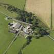
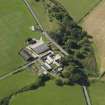
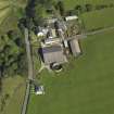
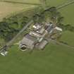
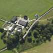
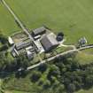
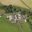
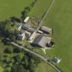
Meikle Kilmory is a working farmsteading comprising a mixture of 19th century agricultural buildings and modern sheds, none of which has been recorded in detail. Kilmory Castle, which stands on its N side, is recorded elsewhere (see NS06SE 10).
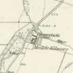
‘Meickle Killmorey’ is depicted on Roy’s Military Map (1747-55) and ‘Meikle Killmory’ is shown on a late-18th century estate map (May c.1780-2). The 1st edition of the OS 6-inch map (Buteshire 1869, Sheet CCIV) depicts four buildings and ranges here, as well as a garden immediately E and an enclosure directly S. One of the buildings, probably the S range, must have incorporated a water-wheel, powered via a lade from a pond 130m to the E. A new farmhouse, which was constructed in the late 19th century, is depicted on the 2nd edition of the 25-inch OS map (Buteshire 1897, Sheet CCIV. 13).
Information from RCAHMS (GFG) 25 March 2010.
Antiquarian Mapping (1747 - 1755)
Antiquarian Mapping (1758 - 1759)
Antiquarian Mapping (1780 - 1782)
Aerial Photography (1935 - 1938)
An collection of aerial photographs taken by Andrew P Hunter from 1935 to 1938. Digitised by Andrew B Wilson in 2008.
Note (25 March 2010)
Meikle Kilmory is a working farmsteading comprising a mixture of 19th century agricultural buildings and modern sheds, none of which has been recorded in detail. Kilmory Castle, which stands on its N side, is recorded elsewhere (see NS06SE 10).
‘Meickle Killmorey’ is depicted on Roy’s Military Map (1747-55) and ‘Meikle Killmory’ is shown on a late-18th century estate map (May c.1780). The 1st edition of the OS 6-inch map (Buteshire 1869, Sheet CCIV) depicts four buildings and ranges here, as well as a garden immediately E and an enclosure directly S. One of the buildings, probably the S range, must have incorporated a water-wheel, powered via a lade from a pond 130m to the E. A new farmhouse, which was constructed in the late 19th century, is depicted on the 2nd edition of the 25-inch OS map (Buteshire 1897, Sheet CCIV. 13).
Information from RCAHMS (GFG) 25 March 2010.

