
Bute, St Blane's


Cross (Early Medieval), Grave Slab (Period Unassigned)
Site Name Bute, St Blane's
Classification Cross (Early Medieval), Grave Slab (Period Unassigned)
Alternative Name(s) Carved Stone 10
Canmore ID 301996
Site Number NS05SE 5.10
NGR NS 0949 5344
Datum OSGB36 - NGR
Permalink http://canmore.org.uk/site/301996


- Council Argyll And Bute
- Parish Kingarth
- Former Region Strathclyde
- Former District Argyll And Bute
- Former County Buteshire
Reference (1893)
Measured Survey (1896)
Reference (1903)
Reference (1984)
Photographic Survey (1991)
Measured Survey (1992)
Reference (2001)
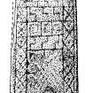
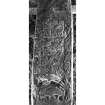
Free-standing cross of white sandstone, re-used as a graveslab S of the nave of the church. It is carved on one face and appears to be complete at the foot, but the side-arms and upper part of the head are lacking and it is much worn and lichen-stained. It measures 1.93m in surviving height by 0.52m in maximum width, and tapers in thickness from 175mm at the butt to 120mm at the head. Two semicircular recesses about 100mm in diameter form the lower armpits, but both edges are damaged so that their exact shape is uncertain although it is probable that the margin of the shaft continued round them. A boss about 180mm in diameter and at least 35mm high projects at the centre of the head but no other detail is preserved in this area. The shaft preserves traces of 30mm edge-mouldings, and within them vertical panels of plaitwork, 80mm wide, which frame central panels of geometric ornament. The upper of these includes step-patterns and the other is a plaited saltire. In the lower part of the shaft, above a plain butt 0.35m high, there is a panel of animal-ornament which extends to the edges and is carved in higher relief than the panels above. It shows a large central quadruped, with a horn or lappet and a curving tail, in a grazing posture with its tongue projecting between long open jaws (k). Forming an arch round it there are three smaller animals of similar character, two of them leaping up at the sides and the third above them with legs and jaws outstretched.
(Hewison 1893, 1, 220-1; Anderson 1900, 322 and fig.31 on p.321; Allen and Anderson 1903, 3, 407, no.1 and fig.425 on p.408; Schultz album, pl.7; Cross 1984, B13).
Fisher 2001.
Note (June 2017)
What is Cenn Garah and how has it changed over time?
A Google view of the monastic site shows that it sits in a green glen, with a wooded cliff on the west side and is surrounded by a thick wall around the north and east sides. This wall is known as the ‘cashel’. This wall would have separated the spiritual ground from the everyday, secular world. Within the spiritual space are a series of buildings, walled burial grounds and other features that can help us construct a story of the life of Cenn Garah.
If you get the chance to visit St Blane’s you will approach the site from the southern end, whereas the monastic population would have used a gateway through the cashel wall on the east side. A carved stone was found next to this gateway, which is believed to have been the base of a tall carved stone cross that would have welcomed the members to the monastic community.
Today the main features of the site, within the cashel, are the 12th century, roofless church, which sits inside an oval burial ground. The burial enclosure walls are at least 2m high above the ground, presumably as a result of the accumulation of burials. The burial ground is built over two levels: the upper level was traditionally used for male burials where the lower ground level was used for females. The upper burial ground was still being used until the 12th century church was built.
To the north of the church are a number of features tucked in at the foot of the cliff. To the south is a later building, which was initially the manse and subsequently used as a farm building.
As you wander around the quiet location, which is sheltered from the south-westerly weather by the landscape, you begin to see bits of walling built into the foot of the cliff. Perhaps some of these are the remains of the monastic settlement?
Towards the north end of the site is a circular building, known as the ‘Cauldron’. This very unusual structure may have been a part of an earlier period of occupation, before Christianity came to Bute. One suggestion is that it was an Iron Age building that was later re-used and modified by the monastic settlers. Perhaps it was a space designated for contemplation and retreat?
The re-creation of St Blane’s since the 1890s
The third Marquess of Bute was interested in history and spent time and money conserving some of Bute’s ancient sites, including St Blane’s. Under the guidance of the architect R.W.Schultz, the Marquess’s gardeners and estate labourers rebuilt much of the cashel wall, parts of the church and the enclosing walls of the burial ground. The present day remains of St Blane’s is as a result of this period of re-building, conserving and tidying up of the landscape within the cashel.
Today, this landscape is cared for by Historic Environment Scotland. The grass is regularly mowed, there is signage to help the casual visitor understand some of the features and the stonework of the various buildings and structures is maintained. So the landscape is one which has undergone many changes and is quite different from when the monastery was first established. But if you do get to visit, you may get a glimpse of why such a secluded, tranquil place was chosen as the place to establish a monastery for quiet, contemplation; something that perhaps we all aspire to occasionally, to take us away from our 24 hour, social media-driven lives.
Dr Alex Hale - Archaeology Projects Manager

