
Montrose, Ferryden Viaduct


Railway Viaduct (19th Century)
Site Name Montrose, Ferryden Viaduct
Classification Railway Viaduct (19th Century)
Alternative Name(s) Inchbraoch Viaduct; Montrose Basin
Canmore ID 36268
Site Number NO75NW 53
NGR NO 70690 56619
NGR Description NO 70670 56697 to NO 70728 56531
Datum OSGB36 - NGR
Permalink http://canmore.org.uk/site/36268


- Council Angus
- Parish Montrose
- Former Region Tayside
- Former District Angus
- Former County Angus
NO75NW 53 70690 56619 (NO 70670 56697 to NO 70728 56531)
Viaduct [NAT]
OS (GIS) AIB, April 2006.
Location formerly entered as NO 70690 56619 and NO 7066 5669 to NO 7072 5653.
Not to confused with South Esk (Inchraoch) Viaduct (NO 7074 5705 to 7096 5744), for which see NO75NW 39.
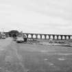
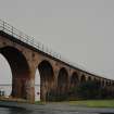
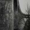
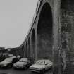
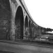
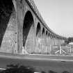
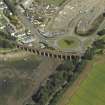
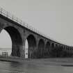
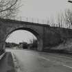
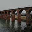
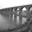
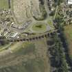
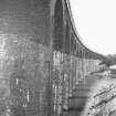
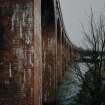
(Location cited as NO 707 567). Viaduct, built c. 1878 by the North British Rly. A 17-span brick viaduct, with semicircular arches.
J R Hume 1977.
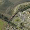
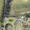
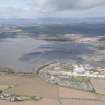
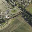
This viaduct carries a single-track section of the Edinburgh-Aberdeen main line of the former North British Rly across the (now-infilled) S arm of Montrose Basin; it opened to traffic in 1881. It is built on a gradient of 1-in-88 around a curve and comprises 17 brick-built spans. It has seen significant repointing and brick-replacement in recent years.
M Smith 1994.
This viaduct remains in regular use by passenger traffic.
Information from RCAHMS (RJCM), 27 September 2000.
A single-track viaduct dating from c.1880 carrying the North British Railway over the south-east end of the Montrose Basin. It comprises 17 red-brick semi-circular arches built on a gentle bend, and at the time of survey in 2002, was still in use as part of the Edinburgh to Aberdeen railway.
Information from RCAHMS (MKO), 2002.
This viaduct carries the Edinburgh-Aberdeen main line of the former North British Rly across the S arm of Montrose Basin and to the SW of Rossie Island (or Inchbraoch). The A92 public road also passes beneath the S end.
The structure is depicted (but not noted) on the 1984 edition of the OS 1:10,000 map, and crosses the boundary between the parishes of Montrose (to the N) and Craig (to the S).
The location assigned to the record defines its apparent midpoint; the available map evidence indicates that it extends from NO c. 70675 56670 to NO c. 70729 56530.
Information from RCAHMS (RJCM), 20 April 2006.

