
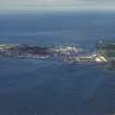
Montrose, South Esk Viaduct


Railway Bridge (19th Century)
Site Name Montrose, South Esk Viaduct
Classification Railway Bridge (19th Century)
Alternative Name(s) Montrose Viaduct; Rossie Island; Inchbraoch Viaduct; Inchbrayock Railway Viaduct; Ferryden Viaduct; River South Esk; Montrose Basin
Canmore ID 36252
Site Number NO75NW 39
NGR NO 70859 57254
Datum OSGB36 - NGR
Permalink http://canmore.org.uk/site/36252


- Council Angus
- Parish Montrose
- Former Region Tayside
- Former District Angus
- Former County Angus
NO75NW 39 70859 57254
Viaduct [NAT]
OS GIS ep. 3.
Location formerly entered as NO 70859 57256 and NO 70745 57057 to NO 70961 57436.
Not to be confused with Ferryden Viaduct (NO 7066 5669 to 7072 5653), for which see NO75NW 53.
For corresponding and successive road bridges (adjacent to E), see NO75NW 55.00 and NO75NW 547.
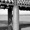
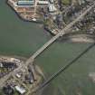
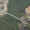
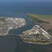
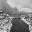
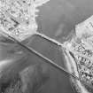
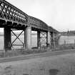
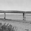
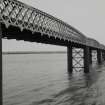
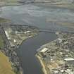
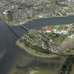
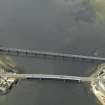
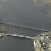
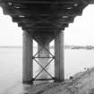
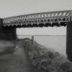
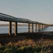
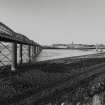
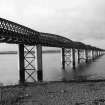
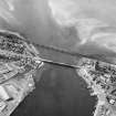
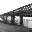
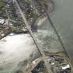
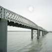
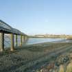
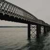
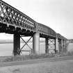
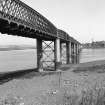
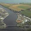
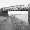
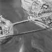
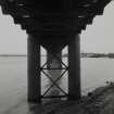
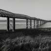
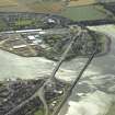
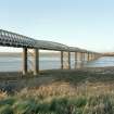
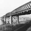
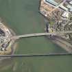
Location cited as NO 708 572). South Esk Viaduct, built 1881 by the North British Rly. A 14-span viaduct, with lattice-girder trusses, slightly bowed, on circular rivetted-iron columns. Total length 1430 ft (440m) .
J R Hume 1977.
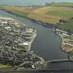
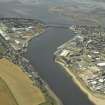
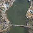
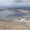
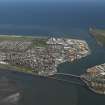
This viaduct carries the Edinburgh-Aberdeen main line of the former North British Rly across the N arm of Montrose Basin. It is the successor to a wrought iron bridge which was designed by Thomas Bouch (as the last of his projects to be constructed) which was demolished in December 1880.
The present structure was opened to traffic in 1881 and carries a single-track section of the line.
Inmformation from RCAHMS (RJCM), 12 April 2000.
M Smith 1994.
Historic Scotland - Delisted 5th April 2000.
(Undated) information in NMRS.
A single-track railway bridge built in 1881 to carry the North British Railway across the mouth of the Montrose Basin, it comprises 14 bowed lattice-girder trusses supported on pairs of circular riveted iron piers, and is 440 metres long. The bridge replaced an earlier structure designed by Sir Thomas Bouch, and at the time of survey in 2002, was still in use as part of the Edinburgh to Aberdeen line.
Information from RCAHMS (MKO), 2002.
This structure is depicted (but not noted) on the 1984 edition of the OS 1:10,000 map and the current OS (GIS) AIB. The location assigned to the record defines its apparent midpoint; the available map evidence indicates that it extends from NO c. 70964 57437 to NO c. 70744 57055.
The entire structure falls within the parish of Montrose.
Information from RCAHMS (RJCM), 20 April 2006.
Construction (1881 - 1883)
Built to design of W R Galbraith.
Information from R Paxton and J Shipway 2007b, 'Civil Engineering heritage: Scotland - Highlands and Islands'.
Publication Account (2007)
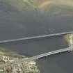
This multi-span 475 yards long railway bridge serving the East Coast Main Line was built in 1881–83 to a design by W. R. Galbraith as a replacement for a viaduct designed by Sir Thomas Bouch. Screw piles beneath the columns of the former viaduct failed during construction. Galbraith’s bridge carries a single rail track on a series of bowstring girders that are supported on concrete-filled piers. William Arrol & Co. were the contractors.
R Paxton and J Shipway 2007b
Reproduced from 'Civil Engineering heritage: Scotland - Highlands and Islands' with kind permission of Thomas Telford Publishers.
Publication Account (2013)
Road: 1828 suspension bridge by Captain Samuel Brown, his longest span at 432ft. In 1930 Sir E Owen Williams completed a replacement in homage to it: a double cantilever bridge of 216 ft main span constructed in reinforced concrete that echoed the form of the previous suspension bridge. This design led to controversy across the Atlantic: “it is regrettable that a freak structure of inappropriate design should have been allowed to succeed the previous 100-year old suspension bridge” (D B Steinmann). Its successor by Balfour Beatty is again shorter in span than the first bridge (look under the beams for the rounded piers of Brown’s bridge).
Railway: a curving brick arched viaduct crosses the road and Rossie Island leading on to a multispan bowstring girder viaduct on concrete filled piers across the channel. This was built in 1881-3 by Sir Wm Arrol contractors to designs by W R Galbraith
M Watson, 2013

