
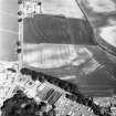
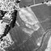
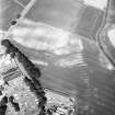
Clayholes


Cropmark(S) (Period Unknown), Enclosure(S) (Post Medieval), Pit(S) (Prehistoric), Rig And Furrow (Medieval) - (Post Medieval)
Site Name Clayholes
Classification Cropmark(S) (Period Unknown), Enclosure(S) (Post Medieval), Pit(S) (Prehistoric), Rig And Furrow (Medieval) - (Post Medieval)
Canmore ID 34526
Site Number NO53NE 6
NGR NO 5590 3520
NGR Description Centred on NO 5590 3520
Datum OSGB36 - NGR
Permalink http://canmore.org.uk/site/34526


- Council Angus
- Parish Barry
- Former Region Tayside
- Former District Angus
- Former County Angus
NO53NE 6 centred 5590 3520
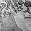
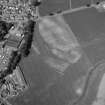
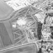
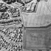
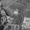
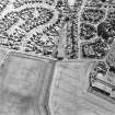
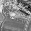
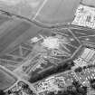
The unenclosed settlement and rig, situated on a SE-facing slope at an altitude of 30-35m OD, adjacent to Lochty Burn, have been recorded as cropmarks in oblique aerial photography (RCAHMSAP 2001). The rig runs in a SW-NE direction and has a distance between furrows of approximately 5m.
Information from RCAHMS (VLW) 16 May 2006

