
Pittenweem Priory Walls


Wall(S) (Period Unassigned)
Site Name Pittenweem Priory Walls
Classification Wall(S) (Period Unassigned)
Canmore ID 34243
Site Number NO50SW 5.03
NGR NO 549 026
Datum OSGB36 - NGR
Permalink http://canmore.org.uk/site/34243


- Council Fife
- Parish Pittenweem
- Former Region Fife
- Former District North East Fife
- Former County Fife
NO50SW 5.3 549 026.
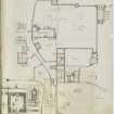
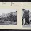
A square building, 20' each way and about 14' high stood till later years projecting into the Marygate. It was locally called the "confessional" and was covered with a stone-flagged roof; it seems to have been part of the N wall of the Priory grounds. This wall is said to have been so broad that two sentinels could walk abreast along the top. There was a great gateway also in this wall, all traces of which have gone. The SDD note that the Kirkyard walls are of various periods up to 1882, and include fragments of the Priory wall.
W F Lyon 1893; SDD List 1962
The priory precinct wall is extant from NO 5496 0255 to NO 5498 0253 (A - B) and NO 5509 0251 to NO 5515 0255 (C - D).
Elsewhere the wall has been destroyed, its course occupied by later walls. There is no trace of the "confessional".
Visited by OS (DWR) 30 May 1974

