
Restenneth Priory


Boundary Stone (19th Century), Carved Stone (Period Unknown)
Site Name Restenneth Priory
Classification Boundary Stone (19th Century), Carved Stone (Period Unknown)
Canmore ID 33799
Site Number NO45SE 51
NGR NO 48096 51647
Datum OSGB36 - NGR
Permalink http://canmore.org.uk/site/33799


- Council Angus
- Parish Forfar
- Former Region Tayside
- Former District Angus
- Former County Angus
NO45SE 51 4810 5167.
See also NO45SE 10.00.
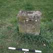
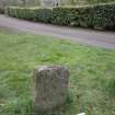
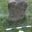
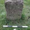
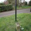
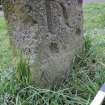
NO 4810 5167. Cup-marked Stone, Prior House: A post-medieval boundary stone adjacent to the car park at Prior House, Restenneth, appears to be a re-used cup-marked stone. Although the block of sandstone has been squared off, three cup-marks each about 55mm in diameter by 17mm deep are visible on the W face of the stone.
J R Sherriff 1981.
Note (3 May 2021)
Date Fieldwork Started: 03/05/2021
Compiled by: ELF
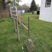
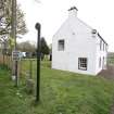
Location Notes: The stone is situated on the grass lawn at the E end of the Reskenneth Priory car park to the W of Prior House at the location NO 48096 51647. The stone is within the immediate vicinity of Reskenneth Priory and burial ground. The stone is a squared-off block of sandstone measuring 0.46m in height, 0.36m in breadth and 0.14m in depth. It has what have previously been described as 3 cupmarks of 55mm in diameter on the W face, along with a deeply inscribed letter 'R', and on the E face a deeply inscribed letter 'L', both letters being 20cm in height. The stone has been described as a 'cup marked' stone re-used as a 'post-medieval boundary stone'. Visualisation of 3D imagery shows that the 'cup marks' appear to have been cut after the stone had been squared by a mason as a boundary marker and cannot therefore be prehistoric and are most likely to be post-medieval (possibly 18th century or later) in date. The lower 'cup mark' has clearly been formed after the skirting to the stone has been carved.

