
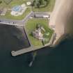
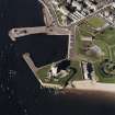
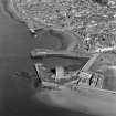
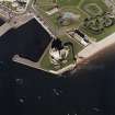
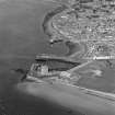
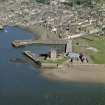
Tay Defences, Broughty Castle Battery


Coastal Battery (First World War), Coastal Battery (20th Century)
Site Name Tay Defences, Broughty Castle Battery
Classification Coastal Battery (First World War), Coastal Battery (20th Century)
Alternative Name(s) Broughty Ferry
Canmore ID 123412
Site Number NO43SE 10.01
NGR NO 4648 3040
Datum OSGB36 - NGR
Permalink http://canmore.org.uk/site/123412


- Council Dundee, City Of
- Parish Dundee (Dundee, City Of)
- Former Region Tayside
- Former District City Of Dundee
- Former County Angus
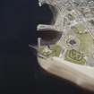
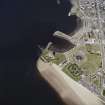
The estuary of the River Tay was heavily defended from the early 20th century, through both First and Second World Wars.
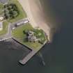
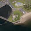
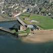
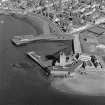
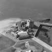
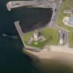
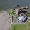
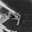
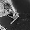
A battery of two Quick Firing (QF) 4.7-inch guns (designed to tackle small fast-moving enemy torpedo boats) was established on the walls of Broughty Castle in 1902, along with three Defence Electric Lights (DELs - large searchlights intended to illuminate targets at night). These guns seem to have been replaced in 1904. The firing arcs of the 4.7-inch guns are marked on a War Office map dated October 1916 and the guns are included in a March 1921 Armament Table on a War Office map of the defences of Aberdeen and Dundee. It is not known when they were withdrawn. On a map drawn between 1901 and 1907 the armament of the battery includes a machine gun. The 4.7-inch guns would have been intended to operate with the larger, 6-inch, guns just to the east, on Castle Green.
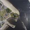
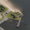
The battery covers a controlled minefield laid across the river, which is about 1.4km across at this point. A War Office map suggests that the expected course of an enemy ship would have been about 600m from the battery.
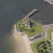
The coast artillery gunnery school was moved from Leith to Broughty Castle in July 1909 and two subsequent War Office plans (dated 1916 and 1923) (The National Archives WO 78/5193; WO 78/5195; WO 78/5196). show the layout of the lecture rooms and other buildings of the school. Plans of the Castle dated October 1916 and September 1923 both show a 6-pdr QF gun emplacement a short distance to the north of the eastern 4.7-inch emplacement, and it is possible that this was for training. The 1923 plan notes that the DELs are retained for training purposes only.
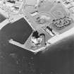
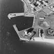
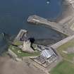
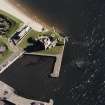
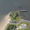
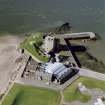
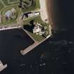
The two emplacements, with fittings and constructional details survive in a generally complete condition.
Information from HS/RCAHMS World War One Audit Project (GJB) 16 July 2013.
NO43SE 10.01 4648 3040
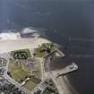
The 19th century gun emplacements later used in the 20th century are situated immediately S and E of Broughty Castle are visible on oblique photographs (visible on RAF [FFO] CPE/Scot/UK/214, 0291-2, flown 1947.
Information from RCAHMS (DE) November 1997
A concrete two gun emplacement are within Broughty Ferry Castle walls. The battery has been demolished but housed two 4.7-inch QF (quick-firing) IVB/III guns which were installed in 1902. These were replaced by two 4.7-inch QF V/CPV guns in September 1904 which were removed by October 1906.
J Guy 2000; NMRS MS 810/9
NO 465 304 In view of the effects of weathering on elements of the two gun emplacements overlooking the Tay estuary on the S side of the castle enclosure, a baseline survey was completed in December 2000.
The gun positions are generally complete with much surviving detail of how the guns were supplied and powered. The range of storage spaces with their own fittings and constructional details, and the variety of cable fixings and tracks, are all evident at present but show signs of degeneration through weathering.
Sponsor: Historic Scotland
G Ewart and A Hollinrake 2001
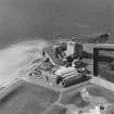
Aerial Photography (September 1970)
Oblique aerial photographs of Broughty Castle, Dundee, taken by John Dewar inSeptember 1970.
Standing Building Recording (18 December 2000 - 19 December 2000)
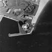
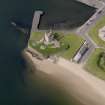
In view of the effects of weathering on elements of the two gun emplacements ( A and B ) overlooking the Tay estuary on the southern side of the Castle enclosure , a baseline survey was completed over 1 day.
The site was recorded via a full photographic record and measured sketches of both emplacements.
The gun positions are generally complete with much surviving detail of how the guns were supplied and powered . The range of storage spaces with their own fittings and constructional details , and the variety of cable fixings and tracks , are all evident at present but show signs of degeneration through weathering . Actual damage is most marked around the edges of the inner recessed squares of both A and B ( contexts F029 and F006 ) and is a product of standing water weakening the fragile edges of the recesses. Elsewhere damage due to weathering is reflected by spalling and cracking . The former is apparent at the northern edges of the gun platform , where water has apparently penetrated beneath the surface of areas F004 ( A ) and F030/031 ( B ). The former is worse than the latter and has resulted in cracking across the platform surface. The section exposed along the north edge of gun emplacement B , through the platform fabric, does not appear to have allowed the same penetration as in A, and also appears to be of a single phase of construction.
In general terms , cracking is evident in any of the exposed elevations and on those areas where the concrete is of finer mix than in the general fabric of the structure. – i.e. on the glacis surfaces , the gun platform surfaces and the face of the access stair in A.
Generally site A was more damaged than B , partly because it is a more elaborate structure with more surfaces to damage , and also because it is more exposed to the elements.
Ideally , both the sites should be drawn at 1: 20 in order to pick up all structural detail and because of the number of curved surfaces and elevations , the sites would be best presented as isometrics or cutaways . In all , this is quite a tricky exercise and would take at least 10 man days on site and probably similar off site .
Sponsor: Historic Scotland
G Ewart and A Hollinrake 2000
Kirkdale Archaeology
Project (March 2013 - September 2013)
A project to characterise the quantity and quality of the Scottish resource of known surviving remains of the First World War. Carried out in partnership between Historic Scotland and RCAHMS.

