
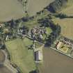
Balmerino Abbey, Abbots House


Monastic Dwelling (Medieval)
Site Name Balmerino Abbey, Abbots House
Classification Monastic Dwelling (Medieval)
Canmore ID 31747
Site Number NO32SE 2.01
NGR NO 35862 24691
Datum OSGB36 - NGR
Permalink http://canmore.org.uk/site/31747


- Council Fife
- Parish Balmerino
- Former Region Fife
- Former District North East Fife
- Former County Fife
NO32SE 2.01 35862 24691
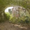
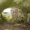
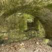
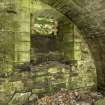
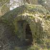
(NO 3586 2469) A building, believed to have been the Abbot's House, lay some 28 yds E of the chapter house of Balmerino Abbey. All that remains now is the inner of two contiguous vaulted cellars, measuring 18'2" by 15'7", within walls built of ashlar but repaired in rubble. The floor is partly cobbled and partly paved with old tombstones.
RCAHMS 1933, visited 1927; D MacGibbon and T Ross 1896
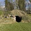
One barrel vault remains of this building, and from its N wall is the springing of another. It is overgrown with vegetation, and its floor is now earth-covered.
Visited by OS (JLD) 2 November 1956
No change.
Visited by OS (RD) 11 June 1970.
Field Visit (20 May 1927)
THE ABBOT'S HOUSE.
Some 28 yards east of the chapter house lay a building which is believed to have been the Abbot's House. All that is now left of it is the inner of two contiguous vaulted cellars with walls and vault built of ashlar but repaired in rubble. The floor is partly cobbled and partly paved with old tombstones. In the east and west walls are windows with segmental rear-arches lintelled externally. These openings have been unglazed.
RCAHMS 1933, visited 20 May 1927.
Excavation (2007)
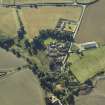
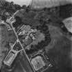
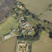
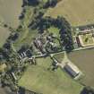
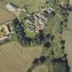
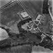
NO 358 246 Alexander II and his mother, Ermengarde, founded Balmerino Abbey, a daughter house of the Cistercian Abbey of Melrose, in 1229. Like Melrose, the conventual buildings were laid out to the N of the abbey church but only remnants of its E range and even less of its church now stand above ground. Nothing is now visible of the abbey's N and W ranges. Parts of the E range were converted into residential accommodation following the abbey's dissolution and sometime later a farm was built over the N side of the abbey. On the
evidence of a date stone set into a cart shed, it has been assumed that the farm dates from the mid-19th century although a study of the farm buildings, together with the findings from excavation suggest that the farm might be considerably older. In the mid- 1990s a proposal to convert the farm steading to residential
accommodation prompted the excavation of a series of trenches to coincide with the service trenches for the redevelopment (DES 1996, 45). The project foundered thereafter but was revived in 2006-7 when more service trenches, as well as larger areas, were excavated. The findings from both seasons were significant. The remains of substantial walls on the S side of the farm provided clear evidence that the abbey's E range had
once extended well beyond its present N limit. The great drain, which ran northwards from the E range, was exposed in 1996 and again in 2006-7 when some of its large roofing slabs were removed. It was built of sandstone rubble on a base course of reused ashlar, indicating that it was not an original abbey feature. The drain also cut through the foundations of a small masonry building nearby, again confirming the feature's secondary nature. Several other box drains, as well as a possible precursor of the great drain, were uncovered around this part of the steading. One of the extant buildings on the N side of the farm was almost certainly a monastic structure. It is often referred to as the 'barn' but this was almost certainly not its original function, being more probably an abbot's house. From its architecture, it could date from any time between the 13th and early 16th centuries. At the E end of the building were the remains of a kiln that had been used for lime burning, at least in its final manifestation. Elsewhere in the 'barn' were traces of a flagged floor and a wall that predated the building. The stump of a wall extending southwards from the SW corner of the building might have linked with the N or W range, although it was difficult to extrapolate its alignment from the scant remains. Remnants of several other walls were uncovered throughout the site, some of them probably medieval and others perhaps the remains of earlier farm buildings.
In 1996 an area of well constructed cobbling was uncovered at the N end of the steading and interpreted as a road. However, in 2006-7 it was clear that the metalling extended over a wider area than originally thought and it is now presumed to be part of a monastic yard.
Archive deposited with RCAHMS.
Funder: Country Property Developments Limited.
J Lewis 2007
Field Visit (March 2010)
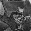
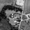
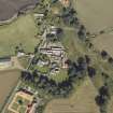
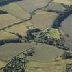
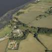
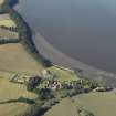
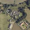
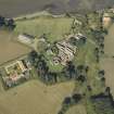
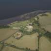
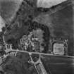
The Cistercian abbey of Balmerino is situated on a terrace overlooking the Tay estuary. Founded in 1226/7 by Alexander II and Queen Ermengarde, it was burned by the English in 1547 and raided by reformers in 1559. After the Reformation the abbey was granted to a series of commendators, who may be responsible for some of the changes which may be seen in the buildings. It was subsequently erected into a lordship for the Elphinstone lords of Balmerino. However, most of the demolition of the surviving buildings appears to have carried out in the early seventeenth century by the second Lord Balmerino for use in the repair of the church at Monifieth.
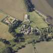
The Monastic Buildings
The surviving features comprised fragments of the abbey church (NO32SE 2.06), the east range, the freestanding building to the east known as the Abbot’s House (NO32SE 2.01) and the large two storey building known as the Abbey Barn to the north (NO32SE 2.02), which was incorporated in the Improvement Period farmsteading (NO32SE 2.04). Nothing of the precinct wall now remains. Campbell (1899, 301) speculates about its course across the field to the south of the abbey church, which is now partly occupied by the almshouses. In this area, he observed a ridge from east to west across the field and identified it as the line of the wall. Although the plough had disturbed some stone work in this area on the date of survey, there was no visible topography to support it. Geophysical survey would be the best method of investigating this possibility.
The abbey is laid out according to a standard Cistercian design, but with the cloister to the north, as at Melrose. Nothing of the north and west range survive except for the raggles of the return of the cloister walls on the church and east range walls. Indeed, it is by no means certain that a west range ever existed since there is no raggle for a parallel wall to make the other side of the range, although there is space for it; because the facings of the wall have been robbed at this point, a range may be inferred. However, the basal chamfer of the cloister wall along the north side of the church runs under the raggle which suggests that the original design of the west range had been changed. Campbell refers to a large building used as stables in the area of the farmhouse, which may have been the west range designed to provide accommodation for the conversi (Campbell 1899, 298).
The east range does not now extend far enough to show any trace of the other wall of the north range. It still stands to first floor level, and to the roofline on two sides of the chapter house. This building with its large mullioned windows and late Gothic vaulting is the most interesting architectural survival on the site. Its north end has been demolished and altered in its conversion to a house for the commendator. The east range includes, from south to north: the sacristry, the chapter house, the stairs to the dormitory, a passage or slype and some cellars, the latter probably belonging to the commendator’s house. The foundations of two parallel walls, revealed in the Scotia excavations to the north of the east range and which were aligned with it, have been interpreted as the east range extending 7–8 m further to the north. The refectory may be presumed to lie in the north range.
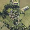
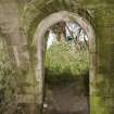
The so-called Abbot’s House (NO32SE 2.01) situated 35 m to the east is a two bay structure with a vaulted basement. Aligned on the same orientation as the rest of the monastery, it measured about 9.5 m by 7.5 m overall, on the assumption that the two basement chambers are of equal size, but it cannot have been much longer due to the cut of the river terrace immediately to the north. Its walls are 1 m thick and are partly faced with thin rubble slabs with some squared ashlar work, suggesting that it had been relieved of its dressed stone. The quoins of the openings are well-constructed in grey sandstone ashlar, as is the vault. There is a chamfered round arched entrance between the two chambers and window lights to east and west in the surviving chamber, with chamfered arrises. A secondary entrance has been cut in the west wall to the south of the window opening, which has been blocked and a press arranged in the blocking. The base of the window in the east wall has been partially blocked. As it stands, it would be small for an infirmary, the suggested alternative to an Abbot’s House. The shallow arched openings of the windows and the round-arched door between the two basements suggest a late medieval date. Campbell notes that it was once called the Commendator’s House and that this became the residence of Lord Balmerino (Campbell 1899, 299). He notes that it was once approached by a stair on its west, now gone, and had another on the east leading to a garden and a kitchen entrance, which may be the opening in the west of the basement.
To the north of the cloisters one abbey building still stands, the so-called Abbey Barn (NO32SE 2.02). This building measures 20 m WSW and ENE by 7.2 m in breadth over brown sandstone rubble walls, 0.9 m in thickness, increasing to 1.2 m at the gable. The building is a parallelogram aligned with the cloisters at the gable but orientated obliquely to the cloisters along its length, probably to avoid existing structures at its east end. It stands two storeys in height and has a steeply pitched roof. There is a scarcement along the inside of the walls above the ground floor windows to support the first floor joists. Any original window lights in the first floor might be expected to have dormers, since no obvious sign remains in the stonework. The skewput on the north-west corner of the building is decorated with a shield bearing an unidentified armorial device.
There is an entrance with a deeply chamfered gothic arch of late thirteenth century date 6 m from the west gable and another wider opening with similar chamfered quoins some 5 m further east. This is a double width entrance suitable for a barn, but its lintel is modern timber, and a two centred arch would leave a trace in the stonework above the entrance. The original opening could have been widened after the Reformation. The domestic scale of the entrance to the west is inappropriate in a barn and there would be less need for a first floor in a barn, although a loft would be a possibility. In between the two entrances there is a slit window with a square head, again of a domestic character. The excavations by Scotia revealed an extensive area of cobbles to the west of the building, with a distinct camber suggesting a roadway. The foundation of a thick wall ran up to the south end of the west gable on the same alignment, which may be the remains of a precinct wall enclosing the outer court of the monastery. Scotia also excavated a kiln, probably of seventeenth century date, in the east end of the barn.
Visited by RCAHMS (PJD) March 2010

