
Mains Of Taymouth


Cropmark(S) (Period Unknown)
Site Name Mains Of Taymouth
Classification Cropmark(S) (Period Unknown)
Alternative Name(s) Taymouth Castle Policies
Canmore ID 24959
Site Number NN74NE 72
NGR NN 774 459
Datum OSGB36 - NGR
Permalink http://canmore.org.uk/site/24959


- Council Perth And Kinross
- Parish Kenmore (Perth And Kinross)
- Former Region Tayside
- Former District Perth And Kinross
- Former County Perthshire
NN74NE 72 774 459
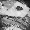
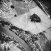
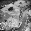
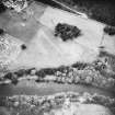
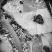
Unenclosed settlement (possible).
(Undated) information in NMRS.
NN 773 458 In January 2001 an archaeological watching brief was carried out on the excavation of a cable trench in the vicinity of unscheduled archaeological sites, notably a group of cropmarks interpreted as the possible remains of an unenclosed settlement (NMRS NN74NE 72).
The only feature of possible archaeological interest was a thin band of silting, seen in a small area to the N of the site. No artefactual remains were encountered within the silt, and it seems likely that this was a natural feature.
Sponsor: Scottish & Southern Energy plc.
M Roy 2001
NN 7745 4590 An evaluation was carried out, 12–13 May 2008, in advance of development works. Six trenches totalling 306m2 were excavated. No features or deposits of archaeological significance were revealed.
Archive: RCAHMS, Perth and Kinross SMR
Funder: Scottish Water Solutions
Ian Hill, 2008 - CFA Archaeology Ltd

