
Eigg, Kildonnan


Grave (Viking), Plate(S) (Viking), Sword (Viking), Whetstone (Viking)
Site Name Eigg, Kildonnan
Classification Grave (Viking), Plate(S) (Viking), Sword (Viking), Whetstone (Viking)
Alternative Name(s) Kildonan; Dail Sithean
Canmore ID 22155
Site Number NM48NE 21
NGR NM 491 854
NGR Description NM c. 491 854
Datum OSGB36 - NGR
Permalink http://canmore.org.uk/site/22155


- Council Highland
- Parish Small Isles
- Former Region Highland
- Former District Lochaber
- Former County Inverness-shire
Note (1928)
NOTE.
In a contribution to the Proceedings of the Society of Antiquaries on March 11, 1878 (vol. xii., 577-597), mention is made of the following additional monuments:
(1) "Foundations of an island dwelling" in a small loch "lying high up on the shoulder of the Scuir of Eigg, known as Lochan na Mna Moire." The island is apparently that in Lochnam Ban Mora (O.S. 6-inch), the only loch here which has an island; it is inaccessible without a boat.
(2) A cairn, "some five or six hundred yards south from Kildonnan," which provided on excavation the articles in [RCAHMS 1928] No. 2 of list on p. lvi.
(3) A cairn "a few yards further south" with articles in No 3.
(4) Cairn, "Sithean or Sguman-nan-Cailleach," containing "two cists . . . made of flat stones set on edge and laid length wise." Stones of cairn removed to fill up a drain. Sithean na Cailleich on O.S. 6-inch lxxi
The O.S. map 6-inch lxxiii. notes a stone cist just north of Kildonnan Old Church ("Ruins of Chapel," cf. Proc. Soc. Ant. Scot., as above, pp. 584-6); the site of one stone cist found in 1861, and of another in 1864, in Galmisdale; the sites of two crosses (lxxi., lxxii.) and Tobar Challuim Chille ("Columba's Well") in Cleadale (lxxi).
RCAHMS 1928
Desk Based Assessment (18 April 1966)
NM48NE 21 c. 491 854
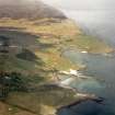
(Area: NM 491 854) About 1830, a Viking grave was discovered in a hillock just below the division fence in a field called Dail Sithean (the field of the tumulus), halfway between St Donan's Church (NM48NE/SE 19, at NM 488 853) and the rocks to the E.
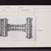
The finds, which are now in the National Museum of Antiquities of Scotland (NMAS), comprise: a sword handle of bronze and silver (Accession no: IL 157) - this dates to between 830 and 850 AD; a few thin plates of bronze; part of a buckle (IL 178); a whetstone, and a triangular piece of metal (? tripod vessel foot) (IL 158).
Information from OS (BRS) 18 April 1966
Sources: N MacPherson 1878; NMAS Catalogue 1892; S Grieg 1940; Kelvingrove Museum 1951
Field Visit (7 May 1972)
There is no local knowledge of this grave, nor of the name 'Dail Sithean'. The most likely spot is a prominent natural rise at NM 4908 8531 in a pasture field.
Visited by OS (AA) 7 May 1972.

