
Iona, Iona Abbey, Michael Chapel


Chapel (Medieval)
Site Name Iona, Iona Abbey, Michael Chapel
Classification Chapel (Medieval)
Alternative Name(s) 'Michael Chapel'
Canmore ID 129130
Site Number NM22SE 5.02
NGR NM 28699 24525
Datum OSGB36 - NGR
Permalink http://canmore.org.uk/site/129130


- Council Argyll And Bute
- Parish Kilfinichen And Kilvickeon
- Former Region Strathclyde
- Former District Argyll And Bute
- Former County Argyll
NM22SE 5.02 28699 24525
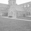
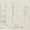
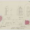
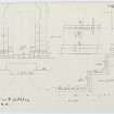
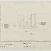
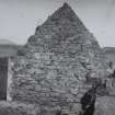
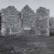
The 'Michael Chapel' stands to the east of the E range of the abbey. Dating from the late 12th or 13th centuries, it appears to be a chapel of the West Highland type. Its name is not of any great age. However, a 16th century record of a burial aisle dedicated to St Michael may be related to this building.
RCAHMS 1982; 1995
Field Visit (June 1980)
Iona Abbey
The restored buildings of the former Benedictine abbey are situated some 250m from the w shore of the Sound of Iona, at an elevation of about 19m OD. The abbey stands near the centre of the area occupied by its Celtic predecessor, as defined by the earthworks of the vallum, and the crosses named after St John, St Martin and St Matthew are prominent features of the area immediately W of the abbey church. The medieval foundation enjoyed continuity not only of site but also of name with the Celtic community, for the current description , 'St Mary's Abbey' , is a misnomer based on the reports of early travellers, who recorded the local tradition that the church was dedicated to the Virgin Mary. Medieval sources relating to the abbey consistently describe it as the 'monastery of St Columba', and the same designation appeared on the conventual seal, which depicted the saint himself. Although some of these references may represent latinisations of the place-name I Chaluim Chille, others are explicit in their application to the monastic house; it appears that the dedication of the church was distinct from that of the abbey as a community.
The immediate area of the Abbey is bounded on the w by the rocky outcrop of Torr an Aba, whose summit was occupied in the medieval period by a free-standing cross, and on the N by Sruth a' Mhuilinn, the mill-stream, from which water was evidently channelled to flush the reredorter. Although Reilig Odhráin was the principal cemetery for laymen during the medieval period, the area s and w of the nave of the abbey church was also used for burial, perhaps serving as the monastic cemetery. This use is represented by a small group of early graveslabs located about 8m S of St Martin's Cross and several interments have been discovered during excavation in the areas indicated. Until the late 18thcentury the abbey was linked to Reilig Odhráin by a medieval paved street, which was re-exposed by excavation in 1962. Similar streets from the Nunnery and from the landing-places at Port nam Mairtir and St Ronan's Bay converged at MacLean's Cross and continued past St Mary's Chapel towards the choir of the abbey church.
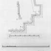
The existing boundaries of the abbey enclosure were established in the 1750s, when steps were taken by the 3rd Duke of Argyll to protect the ruins. The only description of an earlier stone-built wall is given by Sacheverell who, writing in 1688, included Reilig Odhráin within the enclosed precinct. It is known from excavation, however, that both in the medieval period and in the 18th century the area immediately N of Reilig Odhráin and E of the medieval street was cultivated. No trace of a medieval boundary can now be identified, with the doubtful exception of a wall running S for about 95 m from the abbey coffee-house, on the W side of the road below Cnoc nan Carnan. This wall is of unusually massive construction, having a thickness of about 1·4m and incorporating large facing-stones. In the medieval, as in the Early Christian period, elaborate provision was made for the drainage of surface water. A stone-lined drain running ESE was constructed in the partially-silted early ditch at the N boundary of Reilig Odhráin, and a similar drain associated with a boulder-filled soakaway pit at the E edge of the medieval street was built some 30m further N. Numerous stone-lined drains have also been recorded under and near the abbey buildings. They include one, whose course is still partly visible, running from the w mid-buttress of the s wall of the nave towards the SW angle of the S transept; a series of W-E drains discovered in the W part of the cloister garth; a drain which runs from the N door of the refectory undercroft to its SW door; another which was exposed N of the E buttress of the N wall of the refectory and runs SSE below that building, probably continuing as a N-S drain below the E walk of the cloister and thence diagonally below the slype; and a drain underlying the wend of the 'Michael Chapel' , which was traced from a point 5 m N of the N door of the chapel to another point 5 m S of its S wall.
See RCAHMS 1982 pp.49-152 for a full architectural and historical description.
RCAHMS 1982, visited September 1980
External Reference (28 October 2011)
Scheduled as element within 'The monument known as St Mary's Abbey, Iona, monastic settlement [comprising] the remains of the large early historic monastic settlement founded by St Columba in AD 563, St Martin's Cross, and parts of medieval buildings associated with the Benedictine Abbey of St Mary founded around AD 1200.'
Information from Historic Scotland, scheduling document dated 28 October 2011.
Excavation (19 March 2015)
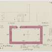
NM 2870 2453 A minor excavation was carried out on 19 March 2015 to locate and repair a burst water pipe between Iona Abbey Museum and the Michael Chapel. No previously undisturbed ground was affected and excavation was restricted to areas of modern intervention. There were no finds or features of archaeological significance.
Archive: National Record of the Historic Environment (NRHE) intended
Funder: Historic Scotland
Paul Fox – Kirkdale Archaeology
(Source: DES, Volume 16)

