
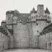
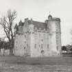
Castle Fraser


Recumbent Stone Circle (Neolithic) - (Bronze Age)
Site Name Castle Fraser
Classification Recumbent Stone Circle (Neolithic) - (Bronze Age)
Alternative Name(s) Castle Fraser Estate; Castle Fraser Policies; Balgorkar; Balgorar; West Mains
Canmore ID 18719
Site Number NJ71SW 3
NGR NJ 7150 1253
Datum OSGB36 - NGR
Permalink http://canmore.org.uk/site/18719


- Council Aberdeenshire
- Parish Cluny
- Former Region Grampian
- Former District Gordon
- Former County Aberdeenshire
NJ71SW 3 7150 1253
See also NJ71SW 4.
(NJ 7149 1252) Stone Circle (NR)
OS 6" map, (1959)
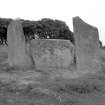
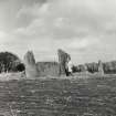
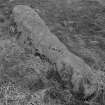
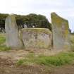
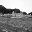
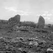
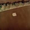
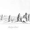
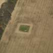
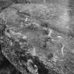
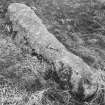
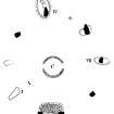
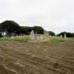
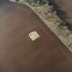
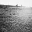
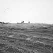
A stone circle of maximum diameter 76ft at Castle Fraser, or Balgorar (now West Mains) was said by Logan (1829) to have consisted originally of eleven stones, nine of which remained. His plan shows a small central circular mound, and a semi-circular one in front of the recumbent stone. Coles (1901) states that by 1900 seven stones from 4ft 9ins to 6ft 6ins high remained upright, and that five of the low set stones which originally composed the circumference of the 13ft diameter inner circle, were still in situ. The whole area of the great circle was paved with boulders at a depth of 6ins, under which, in the inner circle, were charcoal and burnt bones. Black mould or charcoal was also found under several of the large circle stones, and within it towards the south-east side were found two such deposits mixed with fragments of urns made of a thick and coarse paste.
J Logan 1829; F R Coles 1901; A S Henshall 1963.
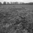
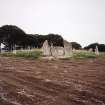
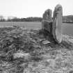
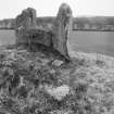
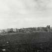
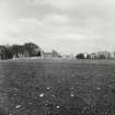
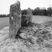
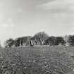
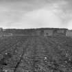
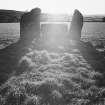
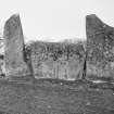
A recumbent-stone-circle, in an arable field, comprising seven standing stones, three of which have now fallen, and a recumbent stone with two attendant pillars. There are faint traces of the central circular mound and the semi-circular one in front of the recumbent stone, mentioned by Logan (1829).
Re-surveyed at 1/2500.
Visited by OS (RD) 11 January 1965.
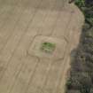
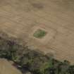
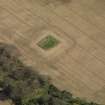
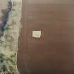
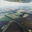
This stone circle is situated in arable ground which falls away to all sides, at an altitude of 130m OD.
Information from Aberdeenshire Archaeological Service, visited 18 October 1977.
NMRS, MS/712/19.
NJ 715 125 An assemblage of finds from Charles Elphinstone Dalrymple's 19th-century excavations at this site, long thought to be lost, were discovered in the Castle Fraser collection. The finds comprise three sherds of Late Bronze Age flat-rimmed ware, a large number of pieces of daub with wattle impressions, and two fragments of charcoal.
The original wrappings of the finds bear the excavation date - 3 September 1856. One wrapper is labelled 'bones', but a thorough search of the collection failed to turn up skeletal material.
Archive to be deposited in NTS SMR.
Sponsor: NTS.
S M Fraser 2003.
Field Visit (16 October 1998)
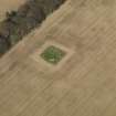
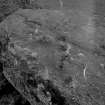
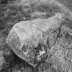
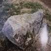
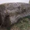
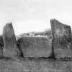
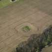
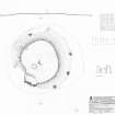
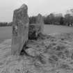
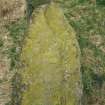
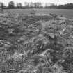
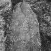
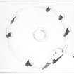
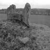
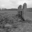
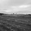
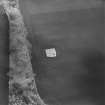
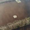
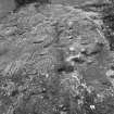
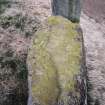
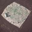
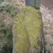
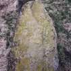
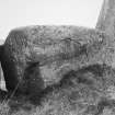
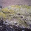
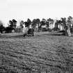
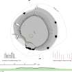
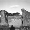
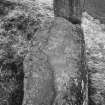
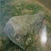
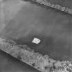
Standing on a low rise in an arable field 340m WNW of the West Lodge of Castle Fraser, this well-known recumbent stone circle measures about 20.5m in diameter. It originally comprised the recumbent setting on the SSW (1–3) and eight orthostats (4–10), but one of the latter is missing on the NNE and three others (7, 9 & 10) were lying prostrate at the time of the survey; since then, in the spring of 2002, another orthostat (4) was knocked over in the course of cultivation and has been broken in two. The recumbent (2) is a block with an even summit and measures 2.25m in length by 1.55m in height. It fits snugly between the two flankers (1 & 3), which are 2.45m and 2.7m high respectively and appear to arc over the ends of the recumbent. The western is a relatively slender pillar standing flush with the front of the recumbent, whereas the eastern is a broader slab set back slightly and turned as if to trace the arc of the circle. The orthostats of the circle are evenly spaced, and though three stones are fallen their sizes lengths leave no doubt that they were designed to reduce in height from the flankers round towards the NE; there is a single cupmark on the N tip of the orthostat lying on the WSW (10). Within the grass-grown interior a low flat-topped mound can be seen, spread by ploughing to a maximum of 20.5m from ESE to WNW by 19.5m transversely and 0.6m in height. Excavation in 1856 by Charles Dalrymple showed that this is the remains of a ring-cairn with a central court about 4m in diameter (below). Nothing is now visible of the court, but three outer kerbstones protrude through the lip of the mound on the WSW, and the tops of another three can be seen a little further round to the N. They lie on a projected circumference about 16m in diameter, while another five larger kerbstones immediately behind the flankers show that its kerb turned outwards on this side to embrace the recumbent setting. There are two shallow depressions on the flat top of the ring-cairn, the northern of which has four boulders lying loose around its lip; these can be seen in the ploughed surface in a photograph taken in 1903 by James Ritchie, which also shows that the scarp that demarcates the N side of what is sometimes described as a raised platform behind the recumbent setting is an accident of plough damage to the rest of the mound rather than a feature of its construction.
Visited by RCAHMS (ATW, IGP and KHJM) 16 October 1998

