
Craigpot


Cottage (Period Unassigned)
Site Name Craigpot
Classification Cottage (Period Unassigned)
Alternative Name(s) Castle Forbes Policies
Canmore ID 151417
Site Number NJ61NW 77
NGR NJ 6313 1883
Datum OSGB36 - NGR
Permalink http://canmore.org.uk/site/151417


- Council Aberdeenshire
- Parish Keig
- Former Region Grampian
- Former District Gordon
- Former County Aberdeenshire
NJ61NW 77 6313 1883
For Castle Forbes (NJ 62148 19130) and associated buildings, see NJ61NW 11.00.
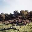
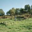
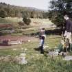
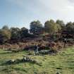
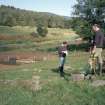
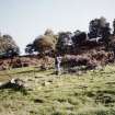
This cottage, which is not depicted on either the 1st or 2nd edition of the OS 6-inch map (Aberdeenshire, 1870, sheet liii and 1901, sheet liii.SW respectively), is situated close to the S bank of the River Don, some 350m E of Craigpot Cottage (NJ61NW 75). It measures 11.6m from NNW to SSE by 4.7m transversely over grass-grown rubble wall-footings 1m in thickness and up to 0.5m in height. A partition divides the interior into two compartments, that at the SSE end forming a small narrow room. A small pen has been inserted into the SSE end of the larger compartment. The grass-grown footings of a second, subrectangular, building measuring about 5.7m from N to S by 3.6m transversely overall, are situated 20m SW of the cottage.
Visited by RCAHMS (JRS, RJCM), 4 October 1996.

