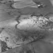
Accessibility

Font Size

100% 150% 200%

Background Colour

Default Contrast
Close Reset

Gordonstown

Farmhouse (Period Unassigned), Farmstead (Period Unassigned)

Site Name Gordonstown

Classification Farmhouse (Period Unassigned), Farmstead (Period Unassigned)

Canmore ID 167255

Site Number NJ52SW 75

NGR NJ 5261 2480

Datum OSGB36 - NGR

Permalink http://canmore.org.uk/site/167255

Ordnance Survey licence number AC0000807262. All rights reserved.
Canmore Disclaimer. © Copyright and database right 2024.

Toggle Aerial | View on large map

Digital Images

Administrative Areas

  • Council Aberdeenshire
  • Parish Clatt
  • Former Region Grampian
  • Former District Gordon
  • Former County Aberdeenshire

Archaeology Notes

NJ52SW 75 5261 2480

For stone circle and other prehistoric discoveries in the area of the steading, see NJ52SW 2 and NJ52SW 3.

References

MyCanmore Image Contributions


Contribute an Image

MyCanmore Text Contributions