
Arkendeith, Tower


Tower House (Medieval)
Site Name Arkendeith, Tower
Classification Tower House (Medieval)
Canmore ID 13558
Site Number NH65NE 2
NGR NH 69593 56062
Datum OSGB36 - NGR
Permalink http://canmore.org.uk/site/13558


- Council Highland
- Parish Avoch
- Former Region Highland
- Former District Ross And Cromarty
- Former County Ross And Cromarty
NH65NE 2 6959 5606
(NH 6959 5606) Arkendeith Tower (NR)
OS 6" map, (1959)
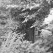
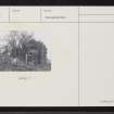
All that remained of Arkendeith Tower, in 1885, was "the lower story, consisting of a strong walled square room, with the arched or vaulted roof of the dungeon still intact."
The name Arkendeith is said to mean 'Black John's Ark' - Black John being a reiver.
A J Beaton 1885.
The remains of Arkendeith Tower consist of a small building, 6.0m square, of which only the vaulted basement survives. The S and W walls remain to a height of 2.1m, the N and E as footings only. The walling of roughly coursed masonry varies between 0.7 - 1.0m thick. The entrance is in the W side and there is a window void in the S wall.
Revised at 1/2500.
Visited by OS (N K B) 21 March 1966.
Note (1979)
Arkendeith Tower NH 695 560 NH65NE 2
A barrel-vaulted cellar is all that now remains of this tower-house.
RCAHMS 1979
NSA, xiv (Ross and Cromarty), 391; Beaton 18858, 405

