
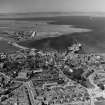
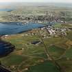
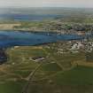
Hatston Airfield


Bomb Store (20th Century), Dispersal Bay(S) (20th Century)
Site Name Hatston Airfield
Classification Bomb Store (20th Century), Dispersal Bay(S) (20th Century)
Canmore ID 269622
Site Number HY41SW 135.03
NGR HY 43991 12579
NGR Description Centred HY 43991 12579
Datum OSGB36 - NGR
Permalink http://canmore.org.uk/site/269622


- Council Orkney Islands
- Parish Kirkwall And St Ola
- Former Region Orkney Islands Area
- Former District Orkney
- Former County Orkney
HY41SW 135.03 centred 43991 12579
The remains of the bomb store for Hatston Airfield survives at the edge of the low cliff NW of Crow Ness. Visible as a line of six concrete double blast walls all with earth mounds. None of the bomb store structures was entered on the date of visit. The three stores to the SE are pre-June 1941, whilst the remaining three were built subsequent to the aerial photography of that date (NLA 16, 615-617, flown 22 June 1941).
Traces of at least five concrete dispersal bays were also noted along the perimeter track to the SW of the bomb store. One (HY 43809 12632), retains the concrete side walls visible on RAF vertical air photographs (CPE/Scot/UK 188, 4175-4176, flown 10 October 1946). There were orginally six dispersal bays all of which were built later than June 1941 as they are not visible on the WW II images (NLA 16, 616-617, flown 22 June 1941).
Visited by RCAHMS (DE), August 2000

