
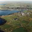
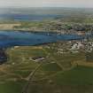
Hatston Airfield


Air Raid Shelter(S) (Second World War), Aircraft Hangar(S) (20th Century), Building(S) (20th Century), Hut(S) (20th Century), Shed(S) (20th Century)
Site Name Hatston Airfield
Classification Air Raid Shelter(S) (Second World War), Aircraft Hangar(S) (20th Century), Building(S) (20th Century), Hut(S) (20th Century), Shed(S) (20th Century)
Canmore ID 269616
Site Number HY41SW 135.02
NGR HY 44032 11793
NGR Description Centred HY 44032 11793
Datum OSGB36 - NGR
Permalink http://canmore.org.uk/site/269616


- Council Orkney Islands
- Parish Kirkwall And St Ola
- Former Region Orkney Islands Area
- Former District Orkney
- Former County Orkney
HY41SW 135.02 centred 44032 11793
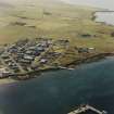
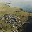
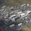
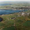
The main technical area for Hatston Airfield is situated to the N of the A965 at the SE end of the runways.
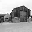
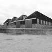
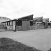
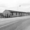
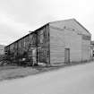
Five large aircraft hangars and two aircraft sheds for flying boats (HY41SW 135.09), survive within Hatston Industrial Estate. The five former aircraft hangars lie in a NW - SE direction whilst the two flying boat sheds are at right angles to these, at the S end. One further hangar, a Mainhill or 'S' type was noted on what is now Crowness Crescent. Immediately S of the 'S' type hangar is a saw-toothed roof building, the former machine shop and to the N, two sectional timber sheds also contemporary to the 1939-1945 period.
All of the above structures except the Mainhill or 'S' type hangar are visible on WW II RAF vertical air photographs (NLA 16, 615-616, flown 22 June 1941), which also shows the original group of what are probably six 'Bellman' type aircraft hangars, four larger and two smaller. The sheds for flying boats lie at the W end of a concrete slipway.
The 'S' type hangar is visible on postwar RAF vertical air photographs (CPE/Scot/UK 188, 4174-4176, flown 10 October 1946) suggesting that this building was added between 1941-1945.
Other buildings of the 1939-45 period survive including a workshop (HY 44069 11709) and a brick and concrete building now annotated as Scott's House (HY 44342 11585 shown on the current OS 1:12500 scale digital maps), all lie within the Industrial Estate, but subsequent alterations possibly disguise some structures origin.
Visited by RCAHMS (DE, GS, SW), August 1999
The Main or Mainhill type aircraft hangar is situated at HY 44677 11665 in what is now Swordfish Road. In addition a large wooden hut constructed in the weather board style is situated immediately NW of the aircraft hangar.
Visited by RCAHMS (DE), 12 September 2008
Note (17 June 2022)
The Pillbox Study Group report five L-shaped air raid shelters are depicted on the OS 1:2500 map (1966), but they are not shown on the current edition of the OS Master Map.
Information from Pillbox Study Group to HES 17 June 2022

