
Aikerness, Broch Of Gurness


Broch (Iron Age), Pictish Symbol Stone (Pictish), Settlement (Viking), Subterranean Structure (Period Unknown)
Site Name Aikerness, Broch Of Gurness
Classification Broch (Iron Age), Pictish Symbol Stone (Pictish), Settlement (Viking), Subterranean Structure (Period Unknown)
Alternative Name(s) Knowe Of Gurness; Aiker Ness; Point Of Helia; Sands Of Evie
Canmore ID 2201
Site Number HY32NE 5
NGR HY 38179 26850
Datum OSGB36 - NGR
Permalink http://canmore.org.uk/site/2201


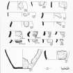


First 100 images shown. See the Collections panel (below) for a link to all digital images.
- Council Orkney Islands
- Parish Evie And Rendall
- Former Region Orkney Islands Area
- Former District Orkney
- Former County Orkney
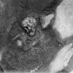
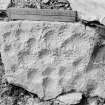
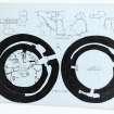
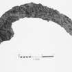
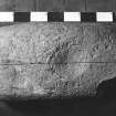
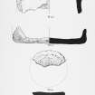
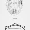
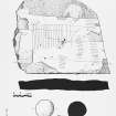
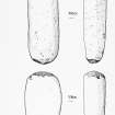
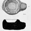
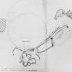
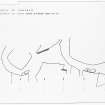
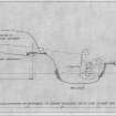
Gurness 2, Broch of Gurness, Orkney, cross-slab
Measurements: H 0.85m, W 0.24m
Stone type: sandstone
Place of discovery: HY 3817 2685
Present location: National Museums Scotland, Edinburgh
Evidence for discovery: found on top of the broch wall during excavations in 1935.
Present condition: good.
Description
The slab is carved with a simple pecked linear cross. Although the slab is roughly rectangular, the axis of the cross is not parallel to the sides of the stone, which may suggest that it was carved on an existing building stone.
Date: sixth or seventh century.
References: Hedges 1987, vol ii, no 306, fig 2.52; Scott & Ritchie 2015, no 16.
Compiled by A Ritchie 2016.
HY32NE 5.00 38179 26850
(HY 3818 2685) Knowe of Gurness (OE)
OS 6" map, Orkney, 2nd ed., (1903).
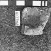
HY32NE 5.01 HY 381 268 Pictish Symbol Stone
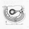
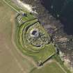
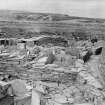
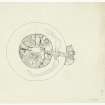
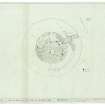
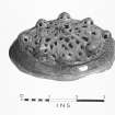
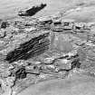
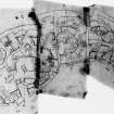
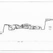
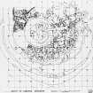
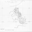
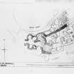
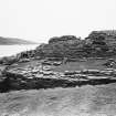
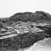
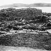
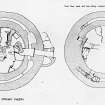
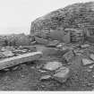
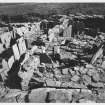
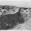
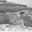
The Broch of Gurness stands 10 ft high and measures 63 ft in diameter over walls 14 to 14 ft 6 ins thick. It was surrounded by a rampart and three ditches and shows three phases of construction and reconstruction, during which outbuildings were erected on the levelled rampart and into the inner ditch.
Subsequently Dark Age and early Viking buildings occupied part of the site (a 10th century Viking woman's grave was inserted into the wall of the outer courtyard). The Broch of Gurness was excavated by, and is under the guardianship of, the MOPBW: some of the later buildings have been re-erected to the west of the broch to expose the earlier outbuildings.
(For full account, plans, etc., see the various authorities.)
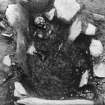
The finds, to be exhibited at the site, included typical 'broch', Dark Age and Viking relics, and fragments of a Roman amphora.
RCAHMS 1946; J S Richardson 1948; V G Childe 1961
The Broch of Gurness is as described and illustrated by the above authorities.
Resurveyed at 1/2500.
Visited by OS (NKB) 7 June 1967.
(Classification of Roman material).
A Robertson 1970
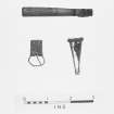
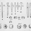
Bronze spiral finger-rings; at least three found on the fingers of a severed hand in a midden. Unpublished.
E J Mackie 1971
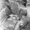
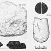
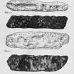
Bone dice found: RMS Unregistered. Numbered 3, 4, 5, 6. One end slightly damaged. 44mm x 21mm. 'Found in broch, probably fallen with debris from wall'. (MSS notebook of J H Craw in the National Museum of Antiquities of Scotland [NMAS], No. 166).
RMS Unregistered. Number 3, 4, 5, 6. The face marked 3 is damaged. 44mm x 20mm. Found SE of the secondary, central hearth in the layer associated with this hearth. (MSS note-books of J H Craw in RMS, entry for June 23, 1932, and No.384).
D Clarke 1970; E J Mackie 1971
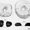
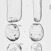
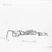
Class I symbol stone showing a divided mirror-case with a rectangle on the left and a divided rectangle on the right.
A Mack 1997.
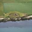
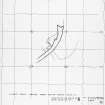
Aerial Photography (1971)
Oblique aerial photographs of Broch of Gurness, Aikerness, by John Dewar in 1971.
Publication Account (1996)
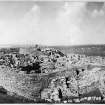
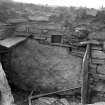
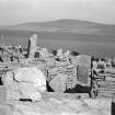
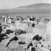
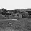
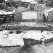
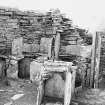
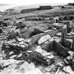
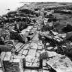
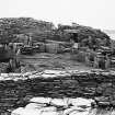
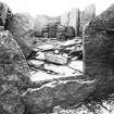
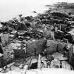
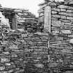
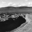
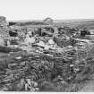
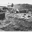
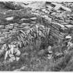
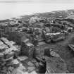
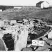
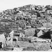
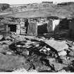
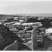
Gurness has the most extensive and well-preserved domestic buildings surrounding the broch to be seen anywhere in Scotland, and these, together with the visitor centre and a superb view across Eynhallow Sound to Rousay, make this monument a truly fascinating place to visit (it is also a very exposed location needing a reasonably calm day to enjoy it). The first buildings that one encounters after entry to the site, close to the visitor centre, are in fact the latest in the seq uence. Before excavation the entire site was a huge grassy mound, and these buildings were found at a high level in the mound, to the north-east of the underlying broch. They were dismantled and re-built in their present position. One is an excellent example of a Pictish house in which five cells surround a central livingroom, and the other is a large oblong house, which has often been assumed to be a Norse hall house but which could equally well be Pictish (artefacts associated with it are unfortunately undiagnostic). There was certainly activity on the site in the Viking age, because a female grave with typical Scandinavian brooches was discovered inserted into the old rampart surrounding the broch (her gravegoods may be seen in Tankerness House Museum: a pair of oval bronze brooches, an iron necklet, an iron sickle and an iron knife with a wooden handle).
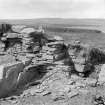
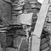
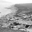
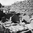
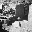
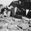
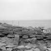
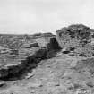
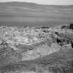
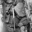
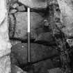
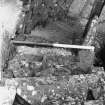
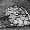
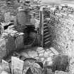
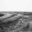
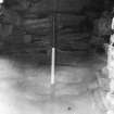
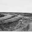
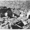
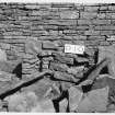
Coastal erosion has destroyed the northernmost part of the site, but it is likely that the outer defences of the broch, a wide band of three ramparts and three ditches, origin ally encircled the broch completely, with an entrance causeway still surviving on the east side. The broch itself was almost certainly built as a tall tower, but its walls have been much reduced in height, probably as a source of building stone; it has a solid wall-base, with cells within the wall on either side of the entrance. The layout on the ground-floor has been complicated by later modifications, but the original design included a well-constructed rectangular hearth and steps leading down to a subterranean cellar with a water-tank fed by a spring, both of which still survive.
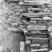
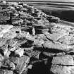
Surrounding the broch and filling the entire space available within the outer defences is a remarkable series of semi-detached houses, which, it has been estimated, might have been the homes of some 30-40 families. The construction of these buildings takes every advantage of the available stone, using large upright slabs as well as horizontal dry stone masonry. Although secondary in the overall sequence of building, it is thought that these houses were inhabited contemporary with the use of the broch, and their arrangement neatly respects the pathway leading from the broch out through the ramparts and ditches.
Information from ‘Exploring Scotland’s Heritage: Orkney’, (1996).
Watching Brief (31 October 2006)
HY 3811 2684 A watching brief was maintained on 31 October 2006 while contactors dug two small test pits and drilled four boreholes near the W side of the existing visitor centre situated in the far NW corner of the guardianship area surrounding the site, in advance of the planned extension to the visitor centre. As expected, the two test pits only revealed an area of modern disturbance associated with the foundations of the visitor centre and related services. The soil and bedrock encountered in the boreholes did not indicate the presence of anything other than natural deposits. Nothing of archaeological significance was noted and no finds were retained.
Archive to be deposited with RCAHMS.
Funder: Historic Scotland.
A Hollindrake 2006
OASIS ID: kirkdale1-249646
Project (24 October 2007 - 25 October 2007)
NY 381 268 An area of 0.8ha immediately surrounding the guardianship site was investigated by gradiometry and resistance survey on 24–5 October 2007. The survey area occupies an undulating arable field, which was under stubble at the time of survey, immediately to the S and SW of the properties in care limits of the Broch of Gurness. The survey area extends northwards to include a small area immediately to the W of the guardianship. The whole survey area lies beyond the limits of the scheduled area. The survey was undertaken with the aim of identifying any anomalies of archaeological interest outside the guardianship area prior to work on the site by Historic Scotland.
The gradiometer data is dominated by responses from ridge and furrow cultivation and recent ploughing. It is possible that the more enhanced ridge and furrow responses indicate the disturbance of earlier, magnetically enhanced, archaeological deposits. The resistance data is dominated by marked changes reflecting a varying depth of bedrock and the effects of ploughing. It is possible that some of the anomalies may be associated with
landscaping of the site.
Archive to be deposited with the Geophysics Unit, Orkney College.
Funder: Historic Scotland.
S Ovenden 2007
Resistivity (24 October 2007 - 25 October 2007)
NY 381 268 Resistivity survey.
Archive to be deposited with the Geophysics Unit, Orkney College.
Funder: Historic Scotland.
S Ovenden 2007
Magnetometry (24 October 2007 - 25 October 2007)
NY 381 268 Magnetometry survey.
Archive to be deposited with the Geophysics Unit, Orkney College.
Funder: Historic Scotland.
S Ovenden 2007
Watching Brief (3 April 2009 - 8 April 2009)
HY 381 268 A watching brief was maintained 3–8 April 2009 during the excavation of a cable trench near the Broch of Gurness. The main trench ran parallel to the outer edge of the fence along the S edge of the guardianship area, terminating at the W side of the ticket office in a series of small trenches excavated to locate existing services. There were no finds or features of archaeological significance.
Archive: RCAHMS (intended)
Funder: Historic Scotland
Andrew Hollinrake – Kirkdale Archaeology
OASIS ID - kirkdale1-249660
Note (26 February 2015 - 1 November 2016)
The Broch of Gurness stands at the core of a complex settlement and is encircled by no less than three walls with external ditches. The broch itself measures a little over 10m in diameter within a wall up to 4.4m in thickness and still standing 3.6m in height; it displays numerous architectural features, including guard cells to either side of the checked entrance on the E, mural chambers and galleries, a well, stairways and a scarcement. The surrounding settlement has encroached on the innermost of the outer defences, apparently entailing the demolition of the innermost wall and its replacement by an irregular curtain which in places is founded in the innermost ditch; this latter was up to 8.5m in breadth. The interior of this enclosure measured about 44m from E to W by at least 37m transversely (0.14ha), though it is uncertain how much has been lost along the seaward flank on the N. And while it is often assumed that this inner wall accompanied the erection of the broch, the overall sequence of construction is unknown, and it is equally possible that this once formed a free-standing enclosure. Indeed, so little about the overall sequence is known that it is equally possible that the middle rampart, itself one of the most impressive elements of the defences as they survive today, may once have formed an enclosure in its own right, taking in a rather larger area of about 0.19ha. On the E, however, a passageway led from the broch through the extramural settlement to what must have been an impressive entrance, where the middle and outer walls turned inwards to unite on either side of the gateway. The precise sequence of fortification and occupation here can only be determined by further work.
Information from An Atlas of Hillforts of Great Britain and Ireland – 01 November 2016. Atlas of Hillforts SC2860
Orkney Smr Note
Broch situated half a mile NNW of Aikerness farm and three-
quarters of a mile ENE of Evie pier. Erosion has removed the
Northern section of the earth works and part of the stone built
structure.
Various periods of occupation are evident; the buildings of
the broch period representing three distinct phases.
In the first arrangement there was a tower of the usual broch
form and a construction standing on a circular platform, margined
by a rampart wall. Later the remains of the tower were re-
adjusted and a complete rebuilding of the platform area.
Following this ditches were filled in and a new ground was
formed. Domestic buildings were raised using old materials. The
latest domestic structures were of early Viking age.
Main dimentions:
Platform - approximately 132ft diameter.
Tower - outer diameter 63ft, interior diameter 34ft.
Well - 14ft deep. Bastion walls 8ft-10ft high.
Great Ditch - 8ft-17ft wide, middle ditch 5ft-6ft wide.
Outer Ditch - 8ft-15ft wide. Tranverse 30ft wide.
A large collection of relics was found including pottery,
iron, bone objects and old stones of various types.
[R1]
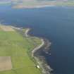
The Broch of Gurness stands on the tip of a promontory known
as Aikerness on the E coast of the mainland.
Excavations began in 1929, gradually revealing a broch and a
complex of later buildings. Gurness was built with a thick stone
base to the tower, which enabled the walls to rise to a
considerable height.
The broch was encircled by three lines of ditch and rampart
with an entrance causeway at the E. The date of erection is
unknown but possibly could have been in the 1st Century BC.
[R2]
9th Century AD - Cist BC. - One of the buildings is an
excellent example of a Pictish House, with five cells around a
central living room and another is a large oblong house.
Coastal erosion has destroyed the Northern most part of the
site.
The original design included a rectangular hearth and steps
leading down to a subterranean water tank fed by a spring both of
which still survives. [R3]
Full and detailed account of excavation with photos, plans
and general description. [R4]
Information from Orkney SMR [n.d.]

