
Jaw Reservoir


Bunker (Second World War), Decoy Site (Second World War)
Site Name Jaw Reservoir
Classification Bunker (Second World War), Decoy Site (Second World War)
Alternative Name(s) Clyde Aa Defences; Edenbarnet; Cochno Hill, Civil Qf/ql Decoy
Canmore ID 98878
Site Number NS57NW 17
NGR NS 5007 7566
Datum OSGB36 - NGR
Permalink http://canmore.org.uk/site/98878


- Council West Dunbartonshire
- Parish Old Kilpatrick (Dumbarton)
- Former Region Strathclyde
- Former District Dumbarton
- Former County Dunbartonshire
NS57NW 17 5007 7566
World War Two bunker and possible gun emplacement: details in Strathclyde Regional Council SMR.
SRC SMR 1993
This installation may be associated with the Starfish decoy site (NS57NW 38.00) 1500m to the E.
Information from RCAHMS (KM) 4 December 2002.
Field Visit (13 June 2018)
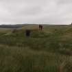
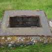
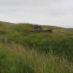
A control shelter (NS57NW 17) and a single enclosure are all that is now visible of this World War Two Civil QF/QL Decoy, which is recorded on recent aerial photographs (Getmapping vertical air photograph, 25 July 2018). It was one of 18 decoys that were constructed to protect the industries in the centre of Glasgow and along the banks of the River Clyde from aerial attack by the Luftwaffe during WWII.
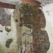
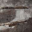
The control shelter (NS 50080 75649), which is situated at the W end of the reservoir’s dam, faces S over marshy ground. It measures 8.7m from E to W by 4.1m transversely over brick walls 0.35m thick and 2.1m high, within a grass-grown earthen blast wall 3.3m thick. This also envelops the flat roof where the capping is up to 0.7m thick, although the reinforced concrete below is visible at the SW and SE corners where the turf has eroded. An escape hatch retaining the iron flange of the trap door is located in the middle of the roof’s W edge, but the cover itself is missing. There is no trace of a baffle shielding the canopied central entrance on the S, but the entrance retains the metal plugs by which the frame of the door was fixed. The latter opens into a corridor 0.93m wide and 4.4m in length. This retains part of the white-washed cement render found throughout the interior. Attached to its N wall are the broken and rusted fragments of a horizontal metal pipe, which acted as a duct for an electricity cable conveying power between the two compartments situated either side of the corridor. The control room on the W, which retains its timber door frame at the entrance, measures 3.35m square and 2.15m high. Unusually, the roof has been strengthened across the centre with two iron girders running from E to W. Six steel rungs attached to the W wall permit egress from the escape hatch and there is a hole in the SE corner of the roof for the chimney pipe of a stove. In addition, there is another circular opening in the W wall just below the ceiling at the NW corner, a rectangular vent underneath at floor level, while two battens on the N wall and various stains elsewhere mark the former presence of various fittings. The generator room, situated on the E side of the corridor, measures 3.35m from N to S by 3.02m transversely and 2.15m high. There are plinths for three engines, each retaining four upstanding bolts to secure them and three small circular ducts behind, just above floor level in the E wall, to conduct the gasses outside to the external expansion chambers. However, no trace of these chambers was observed. There is also a circular vent in the wall above them measuring 0.23m in diameter, while a large rectangular vent is situated at floor level close to the W corners in the N and S walls. In addition, there is an iron ring set firmly into the W wall about 0.6m above the floor.
There is no evidence that there was once a gun emplacement here.
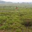
The enclosure for fire baskets (centred NS 49103 75563) is situated on open moorland 970m W of the shelter and is visible from the bunker. It is roughly rectangular on plan and measures 64m from N to S by 29m transversely, within a bilberry-, moss- and heather-grown earthwork consisting of an inner ditch 0.7m broad and 0.2m deep, a bank 1.3m thick and 0.25m high and an outer ditch measuring 0.7m broad and 0.25m deep. It is divided into three compartments and only the most southerly is free of open drains and recently planted conifers.
Visited by HES, Survey and Recording (ATW, AKK) 13 June 2018.

