
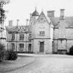
Allanbank


Country House (19th Century)
Site Name Allanbank
Classification Country House (19th Century)
Alternative Name(s) Allanbank House
Canmore ID 94328
Site Number NT85SE 31
NGR NT 85709 54402
Datum OSGB36 - NGR
Permalink http://canmore.org.uk/site/94328


- Council Scottish Borders, The
- Parish Edrom
- Former Region Borders
- Former District Berwickshire
- Former County Berwickshire
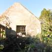
NT85SE 31.01 NT 85440 54568 Farmsteading
NMRS REFERENCE:
Architect : David Bryce, 1848.
Demolished in 1969.
Information from Demolitions catalogue held in RCAHMS Library.
(Undated) information in NMRS.
Allanbank House is not named on the OS 1:10,000 map, although it is depicted on the 2nd edition series (Berwickshire) sheet XVII, 6, 1908. It has since been demolished.
Information from RCAHMS (AR) 3 May 2000.
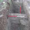
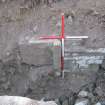
Watching Brief (6 November 2007 - 7 November 2007)
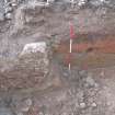
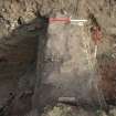
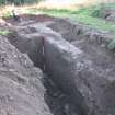
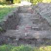
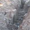
NT 8570 5440 The history of the site was traced from the early medieval period and there were at least three significant building complexes, the Castle of East Nisbet (15th- to 17thcentury), a 17th- to 18th-century country house, and Allanbank House (1848–1968) built by David Bryce. A watching brief was maintained on 6–7 November 2007 as a total of three service trenches and three trial trenches were excavated over the proposed footprint of a new development.
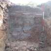
The evaluation trenches exposed parts of the S and E limits of the Bryce house, demolished in 1968. A previous
owner commented that much of the building stone had been salvaged and the remaining demolition debris
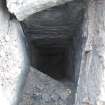
landscaped flat. The remains of the house were relatively well defined by truncated wall lines with areas between these apparently external walls infilled with light rubble and general debris. The excavation revealed the presence of cellarage. The irregular alignment of the outer S walls is reflected by a probable window and doorway, the latter also showing the presence of an external series of at least two steps, the N one of which has been robbed out.
Nothing of any earlier occupation was observed, which may be due to the apparently extensive landscaping of
the natural ground surface when the Bryce house was constructed. The site appears to have been cleared down to firm clays, which lie at a general depth of 0.5m below topsoil. The contents of the service trenches also suggest that the site had been cleared towards the S limits of the available building platform.
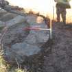
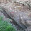
The drain in Trench 6 may have some association with a pronounced rounded depression lying NW of the Bryce
house, a possible pond or garden feature, drained or fed by the drain. The feature appears to have been an open, deep channel and may have been a feature of the 19th-century garden layout to the NW of the Bryce house, as opposed to a simple field drain.
Archive: RCAHMS (intended)
Funder: Mr J Church
Gordon Ewart (Kirkdale Archaeology), 2008
Archaeological Evaluation (October 2015)
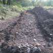
NT 858 544 A programme of archaeological work was carried out, October 2015, on land E of Tofthill in advance of the construction of a new house on land E of Tofthill. The house was constructed on the site of Allanbank House, which was designed by David Bryce in the mid-19th century and
demolished in 1968. Historical records indicate that the 19th-century house replaced an earlier 17th/18th-century house and that prior to this it had been the location of East Nisbet Castle. The excavation of five trial trenches identified the remains of Allanbank House but nothing of the earlier structures.
Archive: NRHE (intended). Report: NRHE and SMR
Funder: C and I Crosby
Ewan MacNeilage and Michael Cressey – CFA Archaeology Ltd
(Source: DES, Volume 17)
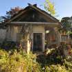
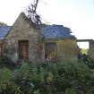
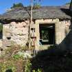
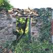
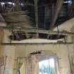
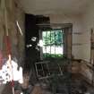
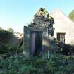
Standing Building Recording (October 2015)
NT 858 544 A programme of archaeological work was carried out, October 2015, on land E of Tofthill in advance of the construction of a new house on land E of Tofthill. As part of the redevelopment of the site a small remaining
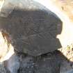
part of Allanbank House had to be demolished. A basic survey of the remains established that these elements were situated in what would have been the corner of the NE wing. Rooms 2 and 4 probably functioned as a pantry or dairy, whilst the rows of hooks on the ceiling suggest that Room 3 was a game larder. It is possible that Room 1 was part of a much larger kitchen. Built at a time before the advent of refrigeration, this part of Allanbank House would have been the coldest, being on its N side.
Archive: NRHE (intended). Report: NRHE and SMR
Funder: C and I Crosby
Ewan MacNeilage and Michael Cressey – CFA Archaeology Ltd
(Source: DES, Volume 17)
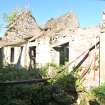
Demolition Application
Demolition of the surviving upstanding elements of Allanbank House commenced in October 2015. Construction of a replacement house on the footprint of the original house also took place beginning in October, 2015.

