
Garrywhin


Cairn (Period Unassigned), Peat Cutting (Period Unassigned), Quarry(S) (Period Unassigned), Stone Row (Neolithic) - (Bronze Age)
Site Name Garrywhin
Classification Cairn (Period Unassigned), Peat Cutting (Period Unassigned), Quarry(S) (Period Unassigned), Stone Row (Neolithic) - (Bronze Age)
Canmore ID 9016
Site Number ND34SW 18
NGR ND 31382 41291
Datum OSGB36 - NGR
Permalink http://canmore.org.uk/site/9016


- Council Highland
- Parish Wick
- Former Region Highland
- Former District Caithness
- Former County Caithness
ND34SW 18 31382 41291.
(ND 3140 4131) Cairn & Stone Rows (NR)
OS 1:10,000 map, (1976)
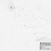
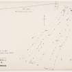
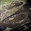
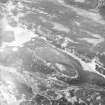
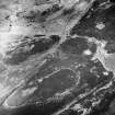
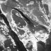
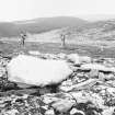
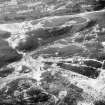
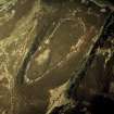
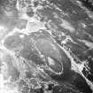
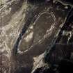
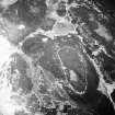
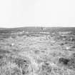
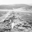
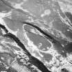
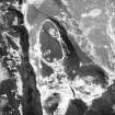
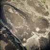
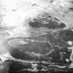
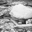
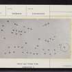
Cairn with cist and associated stone rows. The cairn, excavated by Anderson in 1865, was about 18ft in diameter and contained a cist, 5ft by 2ft 6ins, in which were two oval flint flakes (now in the NMAS), fragments of a beaker and two human molars. Seven or eight rows of low standing stones radiate down the slope from the cairn towards the SSW. The longest row is 194ft in length and the stones stand 8 to 10ft apart, facing across the rows. Thirty-seven remained erect in 1910, with three or four lying displaced.
RCAHMS 1911; J Anderson 1886; M E C Mitchell 1934.
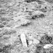
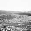
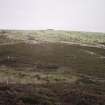
A heather-covered cairn, 10.0m. in diameter, containing a cist, as described by the RCAHMS. Only 30 stones of the stone rows now remain in situ.
Resurveyed at 1/2500.
Visited by OS (N K B) 27 April 1967.
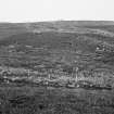
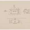
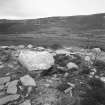
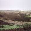
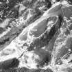
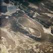
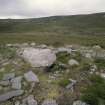
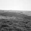
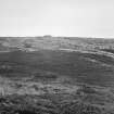
This cairn crowns the summit of a low heather-grown ridge, and is overlooked by the Garrywhin fort (ND34SW 3) to the WNW. The cairn measures 11.2m from N to S by 10.2m transversely over traces of a kerb, the most prominent stones of which are on the SSW. Within the cairn is the cist in which fragments of a Beaker and two human teeth were found during excavations in 1865. The cist is aligned E and W and measures at least 1.3m in length, broadening from 0.7m on the W to 0.83m at its E end, where it is obscured by loose stones. The cover-slab of the cist lies to the S, and is 1.6m long, 1.15m broad and 0.13m thick.
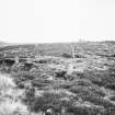
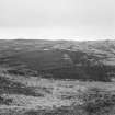
On the slope below, extending away from cairn on the SW, there are no fewer than six rows of stones, covering an area measuring 55m from NNE to SSW by 33m transversely, the lowermost stones running into boggy ground at the foot of the slope. The rows comprise from three to thirteen stones, and are set some 2.9m to 4.5m apart; the gaps between the rows appear narrower on the NNE. In the best preserved row, on the ESE, the stones lie from 1.35m to 3.7m apart and are all thin slabs, some barely visible above the ground-surface; the largest measures 0.65m in length by 0.15m in thickness and stands 0.75m high. On the WNW, the ground drops gently into a boggy hollow, while on the ESE, the edge of the ridge has been quarried (YARROWS04 579) and is flanked by a trackway running up the slope. Immediately SW of the cairn is an area of erosion (YARROWS04 578), while three peat-cuttings (YARROWS04 567-9) are situated to the NNE.
(YARROWS04 58-9, 567-9, 578-9)
Visited by RCAHMS (ARG, ATW) 15 June 2004
Measured Survey (1 July 2004)
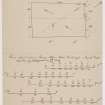
RCAHMS surveyed the stone rows and cairn at Garrywhin on 1 July 2004 at a scale of 1:200. The plan was used as the basis for a vector graphics illustration that was produced at scales of 1:200 and 1:500.

