
Castlesteads Park


Linear Feature(S) (Period Unassigned), Ring Groove House(S) (Prehistoric)
Site Name Castlesteads Park
Classification Linear Feature(S) (Period Unassigned), Ring Groove House(S) (Prehistoric)
Canmore ID 82086
Site Number NT36NW 147
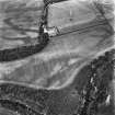
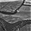
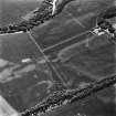
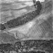
NGR NT 33940 69302
NGR Description From NT 3394 6924 to NT 3415 6958
Datum OSGB36 - NGR
Permalink http://canmore.org.uk/site/82086


- Council Midlothian
- Parish Inveresk (Midlothian)
- Former Region Lothian
- Former District Midlothian
- Former County Midlothian
NT36NW 147 from 3394 6924 to 3415 6958
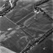
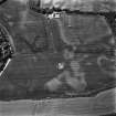
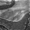
NT 3397 6935 An archaeological excavation of two ring-groove houses and associated features was conducted between February and March 1995 within the proposed road corridor of the A68 Dalkeith Northern Bypass. The site was initially identified as a surface scatter of chipped stone artifacts. The presence of several negative features was then confirmed by trial trenching. Subsequent test-pitting was undertaken to assess the artefact content of the topsoil, and an area of c1000 sq m was excavated.
An almost complete ring-groove structure measuring c10m across was located, within which was a concentric ring of seven post holes. In its SW sector the ring-groove slot was heavily truncated and measured as little as 0.25m in width by 0.10m in depth. In some places the slot was entirely absent. In the remaining sections of the slot, there was less truncation and dimensions, typically from 0.40m to 0.50m wide by 0.25m to 0.35m deep were recorded. No post holes were located in the trench. The entrance, possibly showing evidence of two structural phases, was located on the SE side of the structure. Within the ring-groove fill a small number of quartz and chert flakes were found, along with a red chert scraper, charcoal, and a piece of material which appears to be coal.
To the NE were the heavily truncated remains of a second ring-groove, within which four post holes of an inner ring were preserved. The ring-groove comprised three seperate excavated units. This structure was cut on its N side by a ditch, which appears to be an earlier version of the modern field boundary ditch which presently runs parallel to this, 4m due W.
To the SE of the ring-groove houses were three adjacent, elongated pits, of which the largest, central one had been recut. The function of these features remains unclear; although not fully exposed, they do not appear to have formed the termini of enclosing works around the ring-grooves structures. Within the fills of the central pit were found large numbers of flint and chert flakes, and a small quantity of chert scrapers and flint blades.
Sponsor: Roads Directorate of The Scottish Office Industry Department, managed on its behalf by Historic Scotland.
A Rees 1995.
Site identified during an archaeological assessement carried out by CFA Archaeology Ltd.
Mhairi Hastie, 2006.

