|
Manuscripts |
MS 712/6 |
General Collection |
Copy of Grampian Regional Council SMR record sheet for updates to the SMR in 1994. |
1994 |
Item Level |
|
|
Manuscripts |
MS 810/1 |
Records of Historic Scotland, Edinburgh, Scotland |
Grampian. World War One and Two Defences of Grampian. A survey by John Guy
Volumes 1 & 2 |
1993 |
Item Level |
|
|
Photographs and Off-line Digital Images |
B 92997 PO |
Records of Aberdeenshire Archaeology Service, Aberdeen, Scotland
|
Peterhead airfield: oblique air photograph. |
20/1/1994 |
Item Level |
|
|
Photographs and Off-line Digital Images |
C 47667 |
Records of the German Air Force (Luftwaffe), Second World War Aerial Reconnaissance |
Aerial view. |
1943 |
Item Level |
|
|
Manuscripts |
MS 712/9 |
Records of Aberdeenshire Archaeology Service, Aberdeen, Scotland
|
Photocopies of record sheet relating to updates to the Grampian Regional Council SMR, 1994-5. |
1994 |
Item Level |
|
|
Manuscripts |
MS 712/21 |
Records of Aberdeenshire Archaeology Service, Aberdeen, Scotland
|
(Bound typescript A4) catalogue of photographs from Aberdeen Archaeological Surveys (Grampian Regional Council) aerial reconnaissance, 1994. |
1994 |
Item Level |
|
|
Manuscripts |
MS 712/29 |
Records of Aberdeenshire Archaeology Service, Aberdeen, Scotland
|
(Bound typescript A4) catalogue of photographs from Aberdeenshire Archaeological Service (formerly Grampian Regional Council) aerial reconnaissance, 1997. (Includes sites and monuments in Angus). |
1997 |
Item Level |
|
|
Photographs and Off-line Digital Images |
D 98042 PO |
Records of Aberdeenshire Archaeology Service, Aberdeen, Scotland
|
Peterhead airfield: oblique air photograph. |
20/1/1994 |
Item Level |
|
|
Photographs and Off-line Digital Images |
SC 445499 |
Records of the German Air Force (Luftwaffe), Second World War Aerial Reconnaissance |
Scanned image of Luftwaffe vertcial air photograph of Peterhead Airfield and surrounding area. |
1943 |
Item Level |
|
|
Manuscripts |
MS 2043/470 |
Records of the Council for British Archaeology, York, England |
Defence of Britain Project. Council of British Archaeology.
Highland Anti-invasion.
Details of the Pillbox located at Peterhead Airfield perimeter. |
22/9/2001 |
Item Level |
|
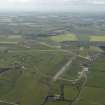 |
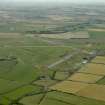
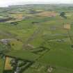
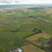
On-line Digital Images |
DP 018247 |
RCAHMS Aerial Photography Digital |
General oblique aerial view centred on the airfield, taken from the ENE. |
6/7/2006 |
Item Level |
|
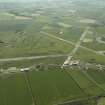 |
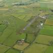
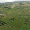
On-line Digital Images |
DP 018248 |
RCAHMS Aerial Photography Digital |
General oblique aerial view centred on the airfield, taken from the NNE. |
6/7/2006 |
Item Level |
|
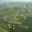 |
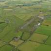
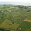
On-line Digital Images |
DP 018249 |
RCAHMS Aerial Photography Digital |
General oblique aerial view centred on the airfield, taken from the NW. |
6/7/2006 |
Item Level |
|
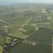 |
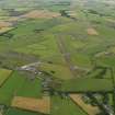
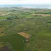
On-line Digital Images |
DP 018250 |
RCAHMS Aerial Photography Digital |
General oblique aerial view centred on the airfield, taken from the NW. |
6/7/2006 |
Item Level |
|
 |
On-line Digital Images |
DP 036457 |
RCAHMS Aerial Photography Digital |
General oblique aerial view centred on the airfield, taken from the NE. |
11/9/2007 |
Item Level |
|
 |
On-line Digital Images |
DP 065238 |
RCAHMS Aerial Photography Digital |
General oblique aerial view centred on the airfield, taken from the E. |
25/7/2009 |
Item Level |
|
 |
On-line Digital Images |
DP 065239 |
RCAHMS Aerial Photography Digital |
General oblique aerial view centred on the airfield, taken from the NE. |
25/7/2009 |
Item Level |
|
 |
On-line Digital Images |
DP 065240 |
RCAHMS Aerial Photography Digital |
General oblique aerial view centred on the airfield, taken from the N. |
25/7/2009 |
Item Level |
|
 |
On-line Digital Images |
DP 065241 |
RCAHMS Aerial Photography Digital |
General oblique aerial view centred on the airfield, taken from the NW. |
25/7/2009 |
Item Level |
|
 |
On-line Digital Images |
DP 065242 |
RCAHMS Aerial Photography Digital |
General oblique aerial view centred on the airfield, taken from the WNW. |
25/7/2009 |
Item Level |
|
 |
On-line Digital Images |
DP 065243 |
RCAHMS Aerial Photography Digital |
General oblique aerial view centred on the airfield, taken from the SW. |
25/7/2009 |
Item Level |
|
 |
On-line Digital Images |
DP 065244 |
RCAHMS Aerial Photography Digital |
General oblique aerial view centred on the airfield, taken from the SSW. |
25/7/2009 |
Item Level |
|
 |
On-line Digital Images |
DP 065245 |
RCAHMS Aerial Photography Digital |
General oblique aerial view centred on the airfield, taken from the SE. |
25/7/2009 |
Item Level |
|
|
Manuscripts |
MS 879/102 |
|
British Airfields, past and present. Map showing all British airfields to compliment the Merseyside Avaiation Society publication 'British Isles Airfield Guide'. |
1976 |
Item Level |
|


