
Bo'ness, General


Town (Period Unassigned)
Site Name Bo'ness, General
Classification Town (Period Unassigned)
Canmore ID 74233
Site Number NS98SE 166
NGR NS 99920 81151
Datum OSGB36 - NGR
Permalink http://canmore.org.uk/site/74233
Ordnance Survey licence number AC0000807262. All rights reserved.
Canmore Disclaimer.
© Copyright and database right 2024.
- Correction
- Favourite

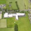
DP 107239
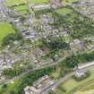
Oblique aerial view of Bo'Ness, centred on Grange School, taken from the SE.
RCAHMS Aerial Photography Digital
22/7/2011
© Crown Copyright: HES

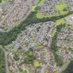
DP 107244
Oblique aerial view of Bo'Ness, centred on Grange House, taken from the NE.
RCAHMS Aerial Photography Digital
22/7/2011
© Crown Copyright: HES

DP 107250
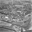
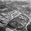
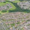
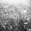
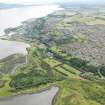
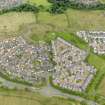
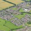
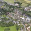
General oblique aerial view of Bo'Ness, taken from the NW.
RCAHMS Aerial Photography Digital
22/7/2011
© Crown Copyright: HES

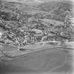
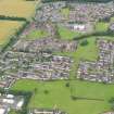
DP 107251
General oblique aerial view of Bo'Ness, taken from the SW.
RCAHMS Aerial Photography Digital
22/7/2011
© Crown Copyright: HES

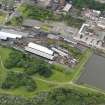
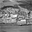
DP 107275
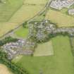
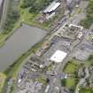
General oblique aerial view of New Grange Foundry and Railway Station, taken from the NE.
RCAHMS Aerial Photography Digital
22/7/2011
© Crown Copyright: HES

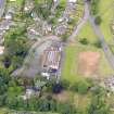
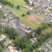
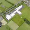
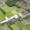
DP 107289
Oblique aerial view of Bo'Ness Public School, taken from the SSE.
RCAHMS Aerial Photography Digital
22/7/2011
© Crown Copyright: HES

DP 107294
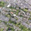
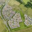
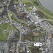
General oblique aerial view of Corbiehall area of Bo'Ness, taken from the SSW.
RCAHMS Aerial Photography Digital
22/7/2011
© Crown Copyright: HES

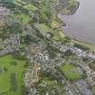
DP 107305
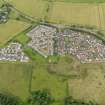
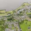
General oblique aerial view of Kinneil area of Bo'ness, taken from the NNW.
RCAHMS Aerial Photography Digital
22/7/2011
© Crown Copyright: HES

DP 107321
General oblique aerial view of the Kinneil area of Bo'ness, taken from the NW.
RCAHMS Aerial Photography Digital
22/7/2011
© Crown Copyright: HES


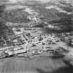
SC 1669393
Aerial view including New Grange Foundry and Railway Station.
RCAHMS Aerial Photography
1991
© Crown Copyright: HES


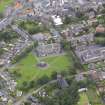
DP 013636
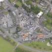
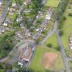
Oblique aerial view centred on the cinema, club and theatre with the church, clock tower, library and town hall adjacent, taken from the WNW.
RCAHMS Aerial Photography Digital
24/4/2006
© Crown Copyright: HES

DP 107210
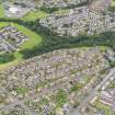
General oblique aerial view of the Drum area of Bo'ness, taken from the NNW.
RCAHMS Aerial Photography Digital
22/7/2011
© Crown Copyright: HES

DP 107241
Oblique aerial view of Bo'Ness, centred on Grange School, taken from the ESE.
RCAHMS Aerial Photography Digital
22/7/2011
© Crown Copyright: HES

DP 107248
General oblique aerial view of Bo'Ness, taken from the N.
RCAHMS Aerial Photography Digital
22/7/2011
© Crown Copyright: HES

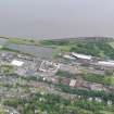
DP 107272
Oblique aerial view of Haymarket Train Shed and Railway Station, taken from the N.
RCAHMS Aerial Photography Digital
22/7/2011
© Crown Copyright: HES

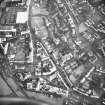
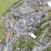
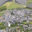
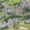
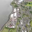
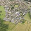
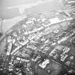
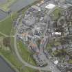
DP 107285
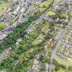
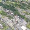
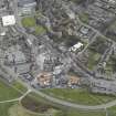
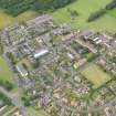
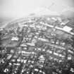
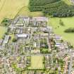
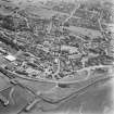
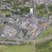
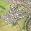
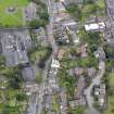
General oblique aerial view of Bo'ness town centre, taken from the SSW.
RCAHMS Aerial Photography Digital
22/7/2011
© Crown Copyright: HES

DP 107288
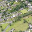
Oblique aerial view of Bo'Ness Town Hall and Carnegie Library, taken from the S.
RCAHMS Aerial Photography Digital
22/7/2011
© Crown Copyright: HES


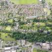
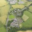
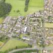
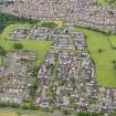
DP 321169
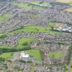
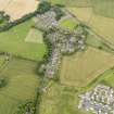
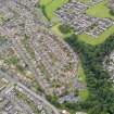
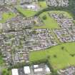
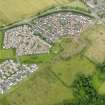
General oblique aerial view of Forthview & Grahams Crescent, and Drumpark Areas of Townscape Character of Bo'ness, taken from NE.
Records of the Royal Commission on the Ancient and Historical Monuments of Scotland (RCAHMS), Edinbu
28/7/2011
© Crown Copyright: HES, Historic Environment Scotland

DP 013639
Oblique aerial view centred on the church, clock tower, library and townhall with the cinema, club and theatre adjacent, taken from the SSE.
RCAHMS Aerial Photography Digital
24/4/2006
© Crown Copyright: HES

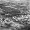
DP 075418
General oblique aerial view of Bo'ness, taken from the SW.
RCAHMS Aerial Photography Digital
12/2/2010
© Crown Copyright: HES

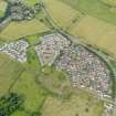
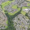
DP 107200
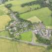
General oblique aerial view of Muirhouses area of Bo'ness, taken from the SSW.
RCAHMS Aerial Photography Digital
22/7/2011
© Crown Copyright: HES

DP 107201
General oblique aerial view of Muirhouses area of Bo'ness, taken from the S.
RCAHMS Aerial Photography Digital
22/7/2011
© Crown Copyright: HES

DP 107202
General oblique aerial view of Muirhouses area of Bo'ness, taken from the SE.
RCAHMS Aerial Photography Digital
22/7/2011
© Crown Copyright: HES

DP 107204
General oblique aerial view of Muirhouses area of Bo'ness, taken from the NE.
RCAHMS Aerial Photography Digital
22/7/2011
© Crown Copyright: HES

DP 107233
Oblique aerial view of Bo'Ness Ship Breakers Yard, taken from the SE.
RCAHMS Aerial Photography Digital
22/7/2011
© Crown Copyright: HES

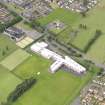
DP 107255
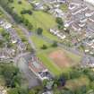
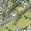
Oblique aerial view of Bo'ness Academy, Gauze Road, Grahamsdyke, Bo'ness, taken from the E.
RCAHMS Aerial Photography Digital
22/7/2011
© Crown Copyright: HES

DP 107263
General oblique aerial view of Drumpark Area of Bo'ness, taken from E.
RCAHMS Aerial Photography Digital
22/7/2011
© Crown Copyright: HES

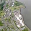
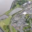
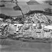
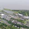
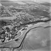
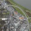
DP 107267
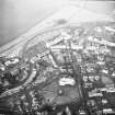
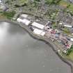
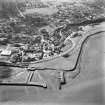
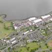
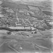
General oblique aerial view of Bo'Ness Harbour, taken from the SW.
RCAHMS Aerial Photography Digital
22/7/2011
© Crown Copyright: HES

DP 107287
General oblique aerial view of Bo'ness town centre, taken from the SSE.
RCAHMS Aerial Photography Digital
22/7/2011
© Crown Copyright: HES

DP 107291
Oblique aerial view of Bo'Ness Public School, taken from the SE.
RCAHMS Aerial Photography Digital
22/7/2011
© Crown Copyright: HES

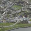
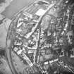
DP 107296
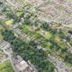
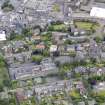
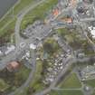
General oblique aerial view of Corbiehall area and town centre of Bo'Ness, taken from the SE.
RCAHMS Aerial Photography Digital
22/7/2011
© Crown Copyright: HES

DP 107300
General oblique aerial view of Corbiehall area of Bo'Ness, taken from the NNW.
RCAHMS Aerial Photography Digital
22/7/2011
© Crown Copyright: HES

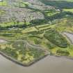
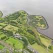
DP 107319
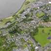
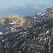
General oblique aerial view of Bo'Ness and Kinneil Nature Reserve, taken from the N.
RCAHMS Aerial Photography Digital
22/7/2011
© Crown Copyright: HES


DP 321171
General oblique aerial view of Hillcrest and Brewlands Area of Townscape Character, Bo'ness, taken from W.
Records of the Royal Commission on the Ancient and Historical Monuments of Scotland (RCAHMS), Edinbu
28/7/2011
© Crown Copyright: HES, Historic Environment Scotland

DP 321173
General oblique aerial view of Forthview and Grahams Crescent, and Hillcrest and Brewlands Areas of Townscape Character, Bo'ness, taken from N.
Records of the Royal Commission on the Ancient and Historical Monuments of Scotland (RCAHMS), Edinbu
28/7/2011
© Crown Copyright: HES, Historic Environment Scotland

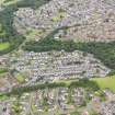
DP 107203
General oblique aerial view of Muirhouses area of Bo'ness, taken from the ENE.
RCAHMS Aerial Photography Digital
22/7/2011
© Crown Copyright: HES

DP 107207
General oblique aerial view of the Drum area of Bo'ness, taken from the SE.
RCAHMS Aerial Photography Digital
22/7/2011
© Crown Copyright: HES

DP 107209
General oblique aerial view of the Drum area of Bo'ness, taken from the N.
RCAHMS Aerial Photography Digital
22/7/2011
© Crown Copyright: HES

DP 107229
Oblique aerial view of Bo'Ness Ship Breakers Yard, taken from the NNW.
RCAHMS Aerial Photography Digital
22/7/2011
© Crown Copyright: HES

DP 107237
Oblique aerial view of Bo'Ness, centred on Grange School, taken from the SSE.
RCAHMS Aerial Photography Digital
22/7/2011
© Crown Copyright: HES

DP 107257
Oblique aerial view of Bo'ness Academy, Gauze Road, Grahamsdyke, Bo'ness, taken from the NE.
RCAHMS Aerial Photography Digital
22/7/2011
© Crown Copyright: HES

DP 107299
General oblique aerial view of Corbiehall area of Bo'Ness, taken from the NNW.
RCAHMS Aerial Photography Digital
22/7/2011
© Crown Copyright: HES

DP 107304
General oblique aerial view of Kinneil area of Bo'ness, taken from the NE.
RCAHMS Aerial Photography Digital
22/7/2011
© Crown Copyright: HES

DP 107307
General oblique aerial view of Kinneil area of Bo'ness, taken from the WNW.
RCAHMS Aerial Photography Digital
22/7/2011
© Crown Copyright: HES

DP 107309
General oblique aerial view of Kinneil area of Bo'ness, taken from the SSW.
RCAHMS Aerial Photography Digital
22/7/2011
© Crown Copyright: HES

SC 1669392
Aerial view including Scrap Metal Docks and Saw Mill.
RCAHMS Aerial Photography
1991
© Crown Copyright: HES


DP 107205
General oblique aerial view of Muirhouses area of Bo'ness, taken from the N.
RCAHMS Aerial Photography Digital
22/7/2011
© Crown Copyright: HES

DP 107235
Oblique aerial view of Bo'Ness, centred on Grange School, taken from the SW.
RCAHMS Aerial Photography Digital
22/7/2011
© Crown Copyright: HES

DP 107265
General oblique aerial view of Drumpark Area of Bo'ness, taken from N.
RCAHMS Aerial Photography Digital
22/7/2011
© Crown Copyright: HES

DP 107270
Oblique aerial view of Haymarket Train Shed and Railway Station, taken from the ENE.
RCAHMS Aerial Photography Digital
22/7/2011
© Crown Copyright: HES

DP 107280
General oblique aerial view of Bo'ness town centre, taken from the WNW.
RCAHMS Aerial Photography Digital
22/7/2011
© Crown Copyright: HES

DP 107283
Oblique aerial view of Bo'Ness Harbour and Railway Station, taken from the WSW.
RCAHMS Aerial Photography Digital
22/7/2011
© Crown Copyright: HES

DP 107295
General oblique aerial view of Corbiehall area and town centre of Bo'Ness, taken from the S.
RCAHMS Aerial Photography Digital
22/7/2011
© Crown Copyright: HES

DP 107306
General oblique aerial view of Kinneil area of Bo'ness, taken from the NW.
RCAHMS Aerial Photography Digital
22/7/2011
© Crown Copyright: HES

DP 107308
General oblique aerial view of Kinneil area of Bo'ness, taken from the WSW.
RCAHMS Aerial Photography Digital
22/7/2011
© Crown Copyright: HES

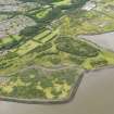
DP 107317
General oblique aerial view of Kinneil Nature Reserve, taken from the SE.
RCAHMS Aerial Photography Digital
22/7/2011
© Crown Copyright: HES

DP 107318
General oblique aerial view of Bo'Ness and Kinneil Nature Reserve, taken from the NE.
RCAHMS Aerial Photography Digital
22/7/2011
© Crown Copyright: HES

SC 1669389
Aerial view showing Victoria Saw Mills.
RCAHMS Aerial Photography
1991
© Crown Copyright: HES

DP 321177
General oblique aerial view of Union Street, Harbour and Dock in Industrial and Shoreline Area of Townscape Character, Bo'ness, taken from S.
Records of the Royal Commission on the Ancient and Historical Monuments of Scotland (RCAHMS), Edinbu
28/7/2011
© Crown Copyright: HES, Historic Environment Scotland

DP 013641
Oblique aerial view centred on the clock tower, library and town hall with the church, cinema, club and theatre adjacent, taken from the NW.
RCAHMS Aerial Photography Digital
24/4/2006
© Crown Copyright: HES

DP 107230
Oblique aerial view of Bo'Ness Ship Breakers Yard, taken from the W.
RCAHMS Aerial Photography Digital
22/7/2011
© Crown Copyright: HES

DP 107253
Oblique aerial view of Bo'ness Academy, Gauze Road, Grahamsdyke, Bo'ness, taken from the SE.
RCAHMS Aerial Photography Digital
22/7/2011
© Crown Copyright: HES

DP 107258
Oblique aerial view of Bo'ness Academy, Gauze Road, Grahamsdyke Road, Bo'ness, taken from the NW.
RCAHMS Aerial Photography Digital
22/7/2011
© Crown Copyright: HES

DP 107260
General oblique aerial view of Drumpark Area of Bo'ness, taken from SSE.
RCAHMS Aerial Photography Digital
22/7/2011
© Crown Copyright: HES

DP 107268
General oblique aerial view of Bo'Ness Harbour and Railway Station, taken from the SSE.
RCAHMS Aerial Photography Digital
22/7/2011
© Crown Copyright: HES

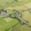
DP 107301
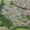
General oblique aerial view of Hillcrest and Brewlands areas of Bo'ness, taken from the SSE.
RCAHMS Aerial Photography Digital
22/7/2011
© Crown Copyright: HES

DP 107320
General oblique aerial view of Bo'Ness and Kinneil Nature Reserve, taken from the W.
RCAHMS Aerial Photography Digital
22/7/2011
© Crown Copyright: HES


SC 1669396
Aerial view including Dock.
RCAHMS Aerial Photography
1991
© Crown Copyright: HES

DP 013640
Oblique aerial view centred on the church, clock tower, library and townhall with the cinema, club and theatre adjacent, taken from the E.
RCAHMS Aerial Photography Digital
24/4/2006
© Crown Copyright: HES

DP 107206
General oblique aerial view of the Drum area of Bo'ness, taken from the SSE.
RCAHMS Aerial Photography Digital
22/7/2011
© Crown Copyright: HES

DP 107231
Oblique aerial view of Bo'Ness Ship Breakers Yard, taken from the SW.
RCAHMS Aerial Photography Digital
22/7/2011
© Crown Copyright: HES

DP 107277
General oblique aerial view of Bo'ness town centre, taken from the NNW.
RCAHMS Aerial Photography Digital
22/7/2011
© Crown Copyright: HES

DP 107292
Oblique aerial view of Bo'Ness Town Hall and Carnegie Library, taken from the ENE.
RCAHMS Aerial Photography Digital
22/7/2011
© Crown Copyright: HES

DP 107298
General oblique aerial view of Corbiehall area of Bo'Ness, taken from the N.
RCAHMS Aerial Photography Digital
22/7/2011
© Crown Copyright: HES

DP 107303
General oblique aerial view of Hillcrest and Brewlands areas of Bo'ness, taken from the E.
RCAHMS Aerial Photography Digital
22/7/2011
© Crown Copyright: HES


SC 1669390
Aerial view including Victoria Saw Mills.
RCAHMS Aerial Photography
1991
© Crown Copyright: HES


DP 321170
General oblique aerial view of Hillcrest and Brewlands Area of Townscape Character, Bo'ness, taken from NE.
Records of the Royal Commission on the Ancient and Historical Monuments of Scotland (RCAHMS), Edinbu
28/7/2011
© Crown Copyright: HES, Historic Environment Scotland

DP 321174
General oblique aerial view of Hillcrest and Brewlands Area of Townscape Character, Bo'ness, taken from E.
Records of the Royal Commission on the Ancient and Historical Monuments of Scotland (RCAHMS), Edinbu
28/7/2011
© Crown Copyright: HES, Historic Environment Scotland

DP 013637
Oblique aerial view centred on the cinema, club and theatre with the church adjacent, taken from the SW.
RCAHMS Aerial Photography Digital
24/4/2006
© Crown Copyright: HES

DP 013638
Oblique aerial view centred on the cinema, club and theatre with the church adjacent, taken from the E.
RCAHMS Aerial Photography Digital
24/4/2006
© Crown Copyright: HES

DP 107208
General oblique aerial view of the Drum area of Bo'ness, taken from the NE.
RCAHMS Aerial Photography Digital
22/7/2011
© Crown Copyright: HES

DP 107242
Oblique aerial view of Bo'Ness, centred on Grange School, taken from the E.
RCAHMS Aerial Photography Digital
22/7/2011
© Crown Copyright: HES

DP 107246
Oblique aerial view of Bo'Ness, centred on Grange House, taken from the NNE.
RCAHMS Aerial Photography Digital
22/7/2011
© Crown Copyright: HES

DP 107262
General oblique aerial view of Drumpark Area of Bo'ness, taken from SE.
RCAHMS Aerial Photography Digital
22/7/2011
© Crown Copyright: HES

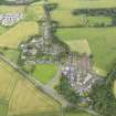
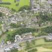
DP 107290
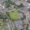
General oblique aerial view of Bo'Ness Old Kirk, taken from the SE.
RCAHMS Aerial Photography Digital
22/7/2011
© Crown Copyright: HES

DP 107293
Oblique aerial view of Bo'Ness Town Hall and Public School, taken from the ENE.
RCAHMS Aerial Photography Digital
22/7/2011
© Crown Copyright: HES


First 100 images shown. See the Collections panel (below) for a link to all digital images.
- Council Falkirk
- Parish Bo'ness And Carriden
- Former Region Central
- Former District Falkirk
- Former County West Lothian
BO'NESS, A CUMING ESQ
19/1/1813 Carron Co. Invoice
17 Ornamental Balusters
17 Common do and 1 Main do Pattern etc.
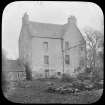
Photographic Survey (March 1964)
Photographs of buildings in Bo'Ness, West Lothian, by the Scottish National Buildings Record/Ministry of Works in March 1964.
Characterisation
This site falls within the Grahamsdyke Road Area of Townscape Character (NT08SW 165), which was defined as part of the RCAHMS Urban Survey Programme 2013. Text relating to the historical development and topography, and present character of the Grahamsdyke Road Area of Townscape Character can be viewed at site NT08SW 165.
Information from RCAHMS (LK), January 2014

