
Allt Cille Pheadair


Field System (Period Unassigned), Hut Circle(S) (Prehistoric)
Site Name Allt Cille Pheadair
Classification Field System (Period Unassigned), Hut Circle(S) (Prehistoric)
Canmore ID 7149
Site Number NC92SE 1
NGR NC 988 200
NGR Description NC 9886 2003, NC 9881 2006 and NC 9888 2009
Datum OSGB36 - NGR
Permalink http://canmore.org.uk/site/7149


- Council Highland
- Parish Kildonan
- Former Region Highland
- Former District Sutherland
- Former County Sutherland
NC92SE 1 988 200.
(A: NC 9886 2003, B: NC 9881 2006 and C: NC 9888 2009) Enclosures (NR)
OS 6"map, (1963)
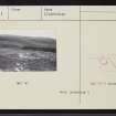
A settlement of three hut-circles (A-C) accompanied by a few field clearance heaps and field banks, lying on a SE- facing slope.
RCAHMS 1911, visited 1909.
'A' has originated as a 'simple' oval hut, measuring 12.1m by 8.7m within an earth and stone bank 0.4m high and spread to 2.6m, and having an entrance in the SE on the line of the longer axis. Inside the hut and partially overlaying the SE wall arc is a secondary circular stone hut of Kilphedir type II (4), 7.3m diameter within a wall of main width 1.1m An entrance passage, splayed and extending into the entrance of the original hut, is 2.4m long 0.9m to 1.2m wide and is flanked by large stones. The remains of a stone wall spring from the back of the secondary structure, and runs for a distance of about 20.0m passing through the wall of the original hut. A slight earth and stone bank springs from the east side of the latter turning sharply to the SE after a few metres.
'B' has been a 'simple' hut some 10.0m diameter internally but only a slight turf bank 0.1m high and 1.7m wide is now visible, with a red grit boulder standing in the east side. An entrance may be indicated by a slight depression in the south.
'C' is a 'simple' hut, slightly scooped out of the slope in the NW and measuring 10.5m by 8.5m internally. A wall width of 2.0m is estimated at a 1.0m wide entrance in the SE on the line of the longer dimension; elsewhere the wall is spread to 1.5m.
Using the Kilphedir excavation as an analogy (H Fairhurst and D B Taylor 1974) the sequence of occupation for this site would appear to be a settlement of three 'simple' huts, with associated field clearance heaps, dating about 500 BC, followed by a re-occupation and reconstruction of a single hut of about 130 BC with associated field banks.
Visited by OS (W D J) 8 December 1976
Details as in previous report. The associated agriculture is heavily masked by peat-silting and cultivation plots are not discernible.
Visited by OS (J M) 8 December 1976.

