
Auldhame


Promontory Fort (Period Unassigned)(Possible)
Site Name Auldhame
Classification Promontory Fort (Period Unassigned)(Possible)
Alternative Name(s) Seacliff Harbour; Seacliffe
Canmore ID 70843
Site Number NT68SW 30
NGR NT 60193 84747
Datum OSGB36 - NGR
Permalink http://canmore.org.uk/site/70843


- Council East Lothian
- Parish Whitekirk And Tyninghame
- Former Region Lothian
- Former District East Lothian
- Former County East Lothian
Aerial Photographic Transcription (1 May 1991 - 3 May 1991)
An aerial transcription was produced from oblique aerial photographs. Information from Historic Environment Scotland (BM) 31 March 2017.
Field Visit (26 February 1996)
A possible promontory fort was noted here presumably from aerial photographs. There was no evidence for a fort at this location, however see also NT 6015 8480.
Site recorded by GUARD during the Coastal Assessment Survey for Historic Scotland, 'The Firth of Forth from Dunbar to the Coast of Fife' 26th February 1996.
Note (17 April 2015)
For the chapel and burial ground at Auldhame see NT68SW 17. For the ditch observed in aerial photography, see NT68SW 65.
Information from RCAHMS (LMcC) 17 April 2015
Note (3 April 2017)
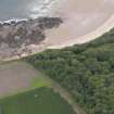
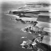
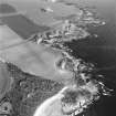
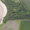
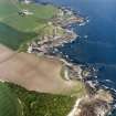
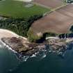
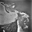
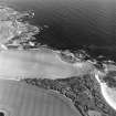
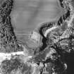
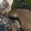
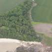
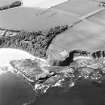
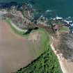
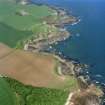
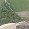
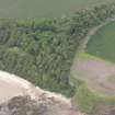
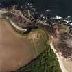
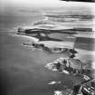
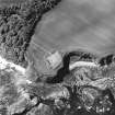
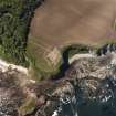
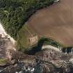
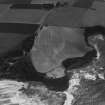
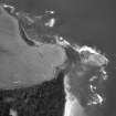
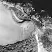
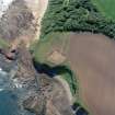
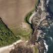
Aerial photography in 1989 identified a ditch cutting off the landward approach to a promontory on the coastal cliffs above Seacliff Harbour, a rocky inlet adjacent to a low stack known as The Gegan, upon which structural remains associated with a midden containing bone needles and pins, a dress-fastener and a decorated comb, together with a Roman gaming piece and a sherd of amphora dating from the 1st or 2nd century AD, were found in the late 19th century (Laidlaw 1870). Girt with cliffs some 20m in height on the NW, NE and SE, the broad ditch barred the approach to the promontory from the SW, enclosing an area measuring about 90m from NW to SE by 60m transversely (0.4ha). Subsequent fieldwork for a coastal survey in 1996 by GUARD on behalf of Historic Scotland observed what was probably the W end of the ditch, about 2m deep, on the cliff-edge, but subsequently ploughing exposed an extensive long cist cemetery which was partly excavated in 2005 and 2008. Carried out by AOC Archaeology Ltd on behalf of Historic Scotland to mitigate damage rather than fully excavate the site, and due to be published shortly, the final report interprets the ditch as part of the vallum of an Anglo-Saxon monastery, in which a timber chapel associated with graves dating from AD 650-780, was replaced about AD 750-850 by a stone founded structure. Evidence of domestic structures dating AD 650-950 were also recovered and the burial-ground remained in use until about 1700. While there is no reason to contest the detail of these conclusions, the incomplete nature of the excavations leaves open the possibility that the monastery had adopted an existing secular cliff-top enclosure, such as seems to have existed at Dunbar (Atlas No.3911).
Information from An Atlas of Hillforts of Great Britain and Ireland – 03 April 2017. Atlas of Hillforts - SC3921

