
Cote, 'girdle Stanes'


Stone Circle (Neolithic) - (Bronze Age)
Site Name Cote, 'girdle Stanes'
Classification Stone Circle (Neolithic) - (Bronze Age)
Alternative Name(s) Girdlestanes; River White Esk
Canmore ID 67234
Site Number NY29NE 13
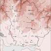
NGR NY 25351 96153
Datum OSGB36 - NGR
Permalink http://canmore.org.uk/site/67234


- Council Dumfries And Galloway
- Parish Eskdalemuir
- Former Region Dumfries And Galloway
- Former District Annandale And Eskdale
- Former County Dumfries-shire
NY29NE 13 25351 96153
(NY 2535 9615) Girdlestanes (NAT)
Stone Circle (NR)
OS 6" map (1965).
For Loupin' Stanes stone circle (NY 2570 9663), see NY29NE 11.
See also NY29NE 24.
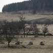
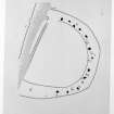
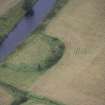
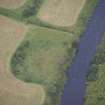
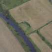
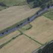
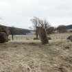
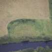
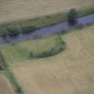
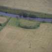
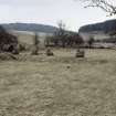
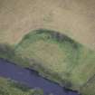
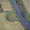
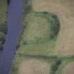
'Girdle Stanes', Stone Circle: The W side of this stone circle has been washed away by the White Esk. What remains is a crescentic arrangement of 26 stones, forming 2/3 of a circle, c.130' in diameter. In the bed of the stream are 6-8 boulders of no great size, possibly part of the missing arc. The stones are placed very irregularly both as regards alignment and distance apart. Of the remaining stones, 10 are erect and pillar-like, one being a double stone; 4 are prostrate pillars, 1 a flat slab, and the rest are squat. The standing stones vary from 1'6"-5'4" in height and the prostrate pillars from 5'6"-7' in length. Probably a considerable number of stones has been removed.
D Christison 1897; G Goldsbrough 1912; RCAHMS 1920, visited 1912.
The twenty-six stones of this circle are set on a slight earthen bank c.3.0m wide. The circle is otherwise as described.
Resurveyed at 1/2500.
Visited by OS (JP), 1 November 1973.
This stone circle is well-preserved. No change to previous field report.
Visited by OS (MJF), 30 August 1978.
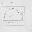
A preliminary geophysical survey of this site was carried out by GeoQuest in November 1993. Geomagnetic data indicated several pits within the enclosure, with additional pits along the line of the stone circle. A weak magnetic anomaly suggested a narrow bank of stoney material, about 8m outside the stone circle. No evidence was found for an enclosing ditch within the surveyed area.
Information from GeoQuest Associates, 1994.
NMRS, MS/730/12.
Scheduled as 'Girdlestanes... the remains of a stone circle...'
Information from Historic Scotland, scheduling document dated 29 October 2010.
Girdlestanes
Stone Circle [NAT]
OS (GIS) MasterMap, November 2010.
Field Visit (June 1980)
Girdle Stanes NY 253 961 NY29NE 13 & 24
On the E bank of the River White Esk, 300m NNW of Cote farmhouse, there is a stone circle measuring about 39m in diameter. The W arc has been destroyed by river erosion but around the E there are eleven upright stones (between 0.8m and 1.8m in height) and eleven fallen stones which are irregularly spaced along the inner edge of what is probably an old plantation bank. Nothing remains of an 'avenue' of stones recorded between this monument and the Loupin' Stanes (NY29NE 11& 25).
RCAHMS 1980, visited June 1980
(Christison 1897; Hyslop and Hyslop 1912, 42; RCAHMS 1920, p. 78, No. 198; Burl 1976, 356; Burl 1979, 170-1)
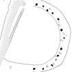
Measured Survey (1 August 1991)
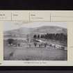
RCAHMS surveyed the Girdle Stanes stone circle on 1 August 1991 with plane-table and self-reducing alidade at a scale of 1:125. The plan was redrawn in ink and published at a scale of 1:250 (RCAHMS 1997, Fig. 104).
Field Visit (1 August 1991)
NY 2535 9615 NY29NE 13
This stone circle is situated on the left bank of the River White Esk about 250m NW of Cote steading (NY29NE 82), and comprises at least twenty-one stones set on a diameter of about 36.5m. Erosion by river action has removed approximately a third of the circle, but thirteen stones, measuring up to 1.65m in height, remain standing. It is not known whether the low stony bank, up to about 7m in thickness, which has been thrown up along the perimeter of the circle is an original feature of the site or no more than field-clearance or a hedge or plantation bank.
Visited by RCAHMS (JRS), 1 August 1991.
Listed as stone circle.
RCAHMS 1997.

