
Newland Hill


Cord Rig (Prehistoric), Fort (Prehistoric), Settlement (Iron Age)
Site Name Newland Hill
Classification Cord Rig (Prehistoric), Fort (Prehistoric), Settlement (Iron Age)
Alternative Name(s) Capelfoot
Canmore ID 67181
Site Number NY28NW 6
NGR NY 24886 86372
Datum OSGB36 - NGR
Permalink http://canmore.org.uk/site/67181


- Council Dumfries And Galloway
- Parish Tundergarth
- Former Region Dumfries And Galloway
- Former District Annandale And Eskdale
- Former County Dumfries-shire
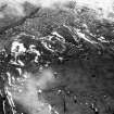
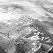
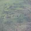
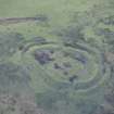
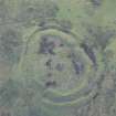
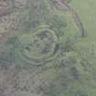
Well-preserved remains of later prehistoric fort located within rough pasture on western edge of Newland Hill summit, overlooking Water of Milk river valley to north, west and south, and Capel Burn valley to south and south-east. Distant views to surrounding landscape possible in all directions other than to east where views are more restricted by topography. Consented Ewe Hill Wind Farm visible in near views to east and existing Minsca Wind Farm visible to southwest.
information from Héléna Gray, (CFA Archaeology Ltd), August 2015
OASIS ID: cfaarcha1-278420
NY28NW 6 2487 8637
(NY 2487 8637) Ancient Earthwork (NAT)
OS 6" map (1957).
Not to be confused with earthwork at NY 25390 86255, for which see NY28NE 1.
Fort.
RCAHMS 1920.
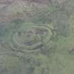
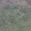
On the summit of a hill is a sub-oval fort measuring internally 66.0m NNW-SSE by 51.0m transversely, between a double earth-and-stone rampart with medial ditch. There are two entrances, in the NE and SW. In the SSE corner of the fort a low earth-and-stone bank, possibly contemporary, cuts off a corner of the interior, producing a small enclosure with an entrance in its N side. Within this enclosure is a probable house platform about 7.5m in diameter.
Revised at 1:2500.
Visited by OS (DWR) 20 March 1972.
Listed among 'Smaller forts and defended settlements'. Although the interior would allow space for timber-built huts additional to the four or five that may now be visible from the surface, it is clear that even if all the enclosed space were so utilised the total complement could never exceed ten.
G Jobey 1971.
No change to the previous field report.
Visited by OS (TRG) 22 September 1978.
Photographed by the RCAHMS in 1980. They list this monument as a settlement.
RCAHMS AP Catalogue 1980.
Field Visit (16 November 1995)
NY 2487 8637 NY28NW 6
Cord rig cultivation is visible immediately to the NE and NW of the fort on the summit of Newland Hill.
Visited by RCAHMS (SPH, ARG), 16 November 1995.
Listed as unfinished fort, timber round-houses and cord rig.
RCAHMS 1997.
Note (19 June 2014 - 23 May 2016)
This fort is situated on the summit of the W spur of Newland Hill. Oval on plan, it measures 66m from NNW to SSE by 51m transversely (0.24ha) within twin ramparts with a medial ditch. The inner rampart stands about 1m high internally and up to 3.5m above the encircling ditch, which is in the order of 5m in breadth, and there are entrances on the NE and SW respectively. Within the interior at least four round-house platforms can be seen, one or two of them lying within an enclosure that has been formed by the insertion of a low stony bank across the SSE end immediately to the S of the SW entrance.
Information from An Atlas of Hillforts of Great Britain and Ireland – 23 May 2016. Atlas of Hillforts SC1031
Project (29 May 2014)
An archaeological evaluation was undertaken by CFA Archaeology Ltd, a desk based assessment and walk over survey (May 29th 2014) was conducted
The historic environment record within the Site Boundary is relatively limited, although there is some potential for the proposed development site to contain previously unknown heritage assets from at least the later prehistoric period onwards, given the historic landscape character of the wider area. Taking this into account, the archaeological potential of the proposed development site is considered to be low.
A summary assessment, on a site by site basis, of the predicted effects on the settings of assets within a 10km radius where the blade tip ZTV indicates that there would be theoretical views of one or more turbines
information from Héléna Gray, (CFA Archaeology Ltd), August 2015
OASIS ID: cfaarcha1-278420

