
Lochwood, The Mount, Lochwood Tower


Building(S) (Period Unknown), Garden (17th Century), Motte (Medieval), Mound (17th Century), Tower House (15th Century)
Site Name Lochwood, The Mount, Lochwood Tower
Classification Building(S) (Period Unknown), Garden (17th Century), Motte (Medieval), Mound (17th Century), Tower House (15th Century)
Alternative Name(s) Lochwood Castle
Canmore ID 66370
Site Number NY09NE 8
NGR NY 08451 96781
NGR Description Centred on NY 08451 96781
Datum OSGB36 - NGR
Permalink http://canmore.org.uk/site/66370


- Council Dumfries And Galloway
- Parish Johnstone
- Former Region Dumfries And Galloway
- Former District Annandale And Eskdale
- Former County Dumfries-shire
NY09NE 8 Centred on NY 08451 96781
(Centred: NY 084968) Lochwood Castle (NR)
(Remains of) The Mount (NAT).
OS 6" map, (1957)
For architectural fragments from this tower-house removed to Raehills (NY 0635 9432), see NY09SE 31. For bell said to have been removed from Lochwood Tower to Johnstone parish church (NY 1002 9135), see NY19SW 77.
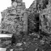
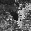
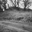
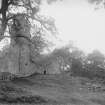
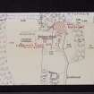
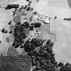
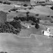
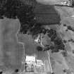
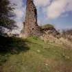
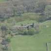
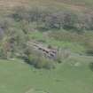
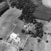
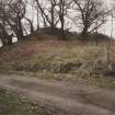
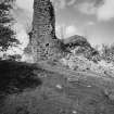
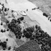
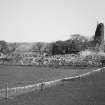
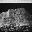
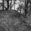
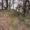
Lochwood Tower, principal seat of the Johnstone clan of Annandale, built apparently in the 15th c, and described in 1547 as a 'fair large tower ... with ... hall, kitchen and stables, all within the barmkin ...' (RCAHMS 1920). Abutting on the N side is a hillock 'apparently in part artificial' (D Christison 1891) named 'The Mount', a scheduled, circular double-terraced motte with ramparts, Norman predecessor of the stone tower. South of the tower, in the centre of a level meadow which was probably the garden, is an artificially-looking, ditched earthen mound, some 9ft high and 36 to 40ft across the base (cf Logan in Galloway). RCAHMS 1920.
Lochwood Tower, its associated outbuildings, and The Mount - a motte, are generally as described and planned. There is no mound to the south only on the west which does not seem to be antiquity.
Resurveyed at 1:2500.
Visited by OS (R D) 26 March 1972
No change to previous field report.
Visited by OS (M J F) 29 August 1978.
Quite extensive remains of a stronghold commanding the upper parts of Annandale, occupied by the Johnstones of that Ilk (later Earls of Annandale) from the late 12th to the early 18th century.
J Gifford 1996.
Description:
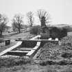
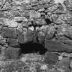
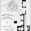
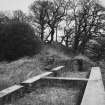
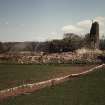
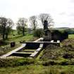
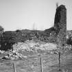
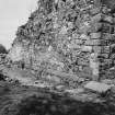
Remains of towerhouse reconstructed following fire in 1593 with - essentially 17th Century - ranges extending N;
abandoned presumably when Raehills was built in the 1780s; walls of N ranges rebuilt during course of 1980s excavations to uniform height (several feet high) and covered with concrete screed. Tower has vaulted basement.
Notes:
Change of Category B to C(S) 22.2.88.
Scheduled Monument 28 February 2000.
References:
MacGibbon and Ross, CASTELLATED AND DOMESTIC ARCHITECTURE, vol IV, 1892 (1977 reprint), p. 399; RCAHM INVENTORY, 1920, no. 315
De-listed September 2009
Information from Historic Scotland
Publication Account (1986)
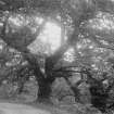
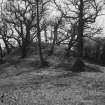
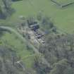
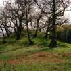
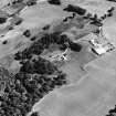
Standing in ancient woodland on the edge of Lochwood Moss this castle was the fortifIed residence of the Johnstone family in Annandale from the 12th to the early 18th century. At the northern end of the site is a motte with an unusual terraced profile; this was the family's first home, probably a timber-built tower associated with a palisaded enclosure. This structure was superseded by a larger stone-built castle, the main element of which was an L-plan tower of late 15th century date, possibly incorporating earlier fragments in re-use. The tower now survives only to first-floor level above vaulted cellars and a prison. A recent programme of clearance and consolidation has also revealed extensive ranges of buildings within the courtyard.
Lochwood was captured and occupied by the English from 1547 to 1550. They described it as 'a fair large tower, able to lodge all our company safely, with a barmkin, hall, kitchen and stables, all within the Iarmkin .. .'. In 1585 the castle was attacked and burnt by the Maxwells, jealous of the rising power of the Johnstones, but life at Lochwood became more peaceful in the 17th century. In the fIelds to the south and west of the ruins are traces of a garden which had a circular mound as its centrepiece, testimony, perhaps, to more settled conditions during the last phase of occupation.
Information from ‘Exploring Scotland’s Heritage: Dumfries and Galloway’, (1986).
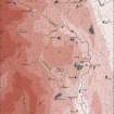
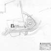
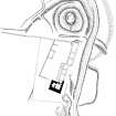
Measured Survey (April 1991 - 15 June 1993)
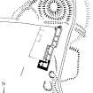
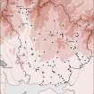
RCAHMS surveyed the castle and motte at Lochwood in April 1991 with plane-table and self-reducing alidade at a scale of 1:500. This plan was then checked on-site and redrawn on 15 June 1993. The resultant plan was redrawn in ink and published at scales of 1:1000 and (RCAHMS 1997, Fig. 225) and 1:2500 (RCAHMS 1997, Fig. 202).
Field Visit (3 June 1991)
NY 0846 9686 NY09NE 8
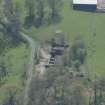
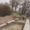
Lochwood Castle, a motte-and-bailey overlain by a later stone castle, lies on the E side of a promontory about 600m long and 400m wide which thrusts northwards into an area of largely-unreclaimed moss. The motte stands to the N, immediately outside the precincts of the later castle. It has been fashioned from a natural mound up to 12m high on the N and E, and up to 6m high on the S and W, its elongated summit measuring 7m from N to S by 4m transversely. The nature of a number of terraces around the sides of the motte is unclear, although they may be the result of later landscaping.
On the S, the bailey is occupied by what remains of the stone castle, the principal feature of which is a late-15th-century L-plan tower-house surviving to first floor height above a vaulted ground floor. A substantial domestic range, its walls standing to a height of about 1.5m, occupies the E side of the courtyard, extending from the the tower-house to the base of the motte, and at its N end there is a well-preserved oven; two smaller buildings lie on the W and N sides respectively of the courtyard.
The site has been excavated and the remains of the buildings have been consolidated, but at the date of visit it was unclear whether some of the visible features had been created during the process of consolidation.
Visited by RCAHMS (IMS), 3 June 1991.
Listed as motte-and-bailey and tower.
RCAHMS 1997.

