|
Print Room |
G 84054 PC |
Records of Ian Gordon Lindsay and Partners, architects, Edinburgh, Scotland |
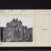
Postcard view.
Insc: 'Barjarg, Dumfriesshire'. |
|
Item Level |
|
|
Prints and Drawings |
DC 15517 |
Alastair Maxwell-Irving |
Plan of original tower. |
17/3/1991 |
Item Level |
|
|
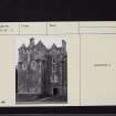
Photographs and Off-line Digital Images |
DF 4 |
|
General view. |
|
Item Level |
|
|
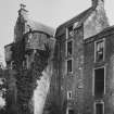
Photographs and Off-line Digital Images |
DF 5 |
|
General view. |
|
Item Level |
|
|
Prints and Drawings |
DFD 45/1 |
|
Plan. |
1912 |
Item Level |
|
|
Print Room |
RAB 255/OPP/144/2 |
General Collection |
Opp. Page No 144/2, Engraving showing country mansion
Insc.: 'Tour de Barjarg. |
1838 |
Item Level |
|
|
Manuscripts |
MS 36/30 |
Records of the Royal Commission on the Ancient and Historical Monuments of Scotland (RCAHMS), Edinbu |
Field sketch and notebook of A L MacGibbon (RCAHMS): principally Galloway, Dumfriesshire, Berwickshire. |
23/2/1912 |
Item Level |
|
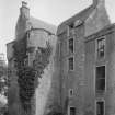 |
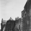
On-line Digital Images |
SC 1168021 |
|
General view. |
|
Item Level |
|
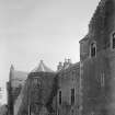 |
On-line Digital Images |
SC 1168027 |
|
General view. |
|
Item Level |
|
|
Photographs and Off-line Digital Images |
J 12836 PO |
Alastair Maxwell-Irving |
Copy of drawing showing survey plan. Barjarg Tower, Keir. |
1991 |
Item Level |
|
 |
On-line Digital Images |
SC 2468163 |
Records of the Ordnance Survey, Southampton, Hampshire, England |
Barjarg House, NX89SE 8, Ordnance Survey index card, page number 1, Recto |
1958 |
Item Level |
|
 |
On-line Digital Images |
SC 2468164 |
Records of the Ordnance Survey, Southampton, Hampshire, England |
Barjarg House, NX89SE 8, Ordnance Survey index card, page number 1, Recto |
1958 |
Item Level |
|
 |
On-line Digital Images |
SC 2468165 |
Records of the Ordnance Survey, Southampton, Hampshire, England |
Barjarg House, NX89SE 8, Ordnance Survey index card, page number 2, Verso |
1958 |
Item Level |
|
 |
On-line Digital Images |
SC 2499447 |
|
General view. |
|
Item Level |
|
 |
On-line Digital Images |
SC 2499448 |
|
General view. |
|
Item Level |
|
|
All Other |
551 166/1/1 |
Records of the Ordnance Survey, Southampton, Hampshire, England |
Archaeological site card index ('495' cards) |
1947 |
Sub-Group Level |
|


