 |
On-line Digital Images |
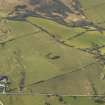
DP 012542 |
RCAHMS Aerial Photography Digital |
Oblique aerial view centred on the remains of the settlement with the farmsteading adjacent, taken from the E. |
2/3/2006 |
Item Level |
|
 |
On-line Digital Images |
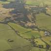
DP 012543 |
RCAHMS Aerial Photography Digital |
General oblique aerial view centred on the remains of the settlement with the farmsteading adjacent, taken from the ENE. |
2/3/2006 |
Item Level |
|
 |
On-line Digital Images |
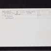
SC 2464032 |
Records of the Ordnance Survey, Southampton, Hampshire, England |
Doonhill, NX44NW 7, Ordnance Survey index card, Recto |
1958 |
Item Level |
|
 |
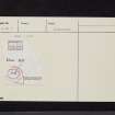
On-line Digital Images |
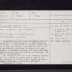
SC 2464033 |
Records of the Ordnance Survey, Southampton, Hampshire, England |
Doonhill, NX44NW 7, Ordnance Survey index card, Recto |
1958 |
Item Level |
|
 |
On-line Digital Images |
SC 2464034 |
Records of the Ordnance Survey, Southampton, Hampshire, England |
Doonhill, NX44NW 7, Ordnance Survey index card, Recto |
1958 |
Item Level |
|
|
All Other |
551 166/1/1 |
Records of the Ordnance Survey, Southampton, Hampshire, England |
Archaeological site card index ('495' cards) |
1947 |
Sub-Group Level |
|


