
Loch Rimsdale


Stone Row (Neolithic) - (Bronze Age)
Site Name Loch Rimsdale
Classification Stone Row (Neolithic) - (Bronze Age)
Canmore ID 6153
Site Number NC73SW 12
NGR NC 7161 3486
Datum OSGB36 - NGR
Permalink http://canmore.org.uk/site/6153


- Council Highland
- Parish Farr
- Former Region Highland
- Former District Sutherland
- Former County Sutherland
NC73SW 12 7161 3486.
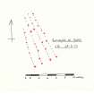
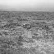
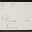
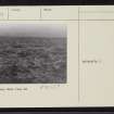
At NC 7161 3486 there is a close-knit group of four stone rows totalling 42 stones. These run from four larger stones to converge northwards over a distance of 12.4m where they disappear under a clearance cairn. Soil movement has probably caused some displacement, hence the irregularity of the rows.
Information from MS, A Field Survey in the Loch Rimsdale Area, June 1975, site ref 12, illust (see archive).
Of the 42 stones noted and planned by Loch Rimsdale Survey, only 30 are above ground level. Otherwise the rows are as described.
Surveyed at 1:10,000.
Visited by OS (J B) 6 April 1977.

